Santry

Cet article est une ébauche concernant une localité irlandaise.

Vous pouvez partager vos connaissances en l’améliorant (comment ?) selon les recommandations des projets correspondants.

Santry
Seantrabh
Santry
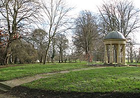
Folie à Santry Demesne
Administration
Pays Drapeau de l'Irlande Irlande
Province Leinster
Comté Comté de Fingal
Géographie
Coordonnées 53° 23′ 56″ nord, 6° 14′ 49″ ouest
Localisation
Géolocalisation sur la carte : Irlande
Voir sur la carte topographique d'Irlande
Santry
Géolocalisation sur la carte : Irlande
Voir sur la carte administrative d'Irlande
Santry
modifier Consultez la documentation du modèle

Santry (Seantrabh en gaélique) est un quartier de la banlieue nord de Dublin dans le Leinster près de Coolock, Glasnevin et Ballymun.

Notes et références

v · m
Quartiers de Dublin, Irlande
Quartiers Nord
  • Applewood
  • Artane
  • Ashtown
  • Baldoyle
  • Balgriffin
  • Ballybough
  • Ballyboughal
  • Ballygall
  • Ballymun
  • Balrothery
  • Bayside
  • Beaumont
  • Blanchardstown
  • Brackenstown
  • Broadstone
  • Cabra
  • Castleknock
  • Chapelizod
  • Clonee
  • Clongriffin
  • Clonsilla
  • Clontarf
  • Coolock
  • Coolmine
  • Corduff
  • Damastown
  • Darndale
  • Dollymount
  • Donabate
  • Donaghmede
  • Donnycarney
  • Drumcondra
  • East Wall
  • Fairview
  • Finglas (en)
  • Garristown
  • Glasnevin
  • Grangegorman
  • Harmonstown
  • Holywell
  • Howth
  • Huntstown
  • Kilmore
  • Kilbarrack
  • Killester
  • Kinsealy
  • Knocksedan
  • Loughshinny
  • Lusk
  • Malahide
  • Marino
  • Mulhuddart
  • Naul
  • North Strand
  • North Wall
  • Oldtown
  • Ongar
  • Oxmantown
  • Palmerstown
  • Phibsborough
  • Poppintree
  • Portmarnock
  • Portrane
  • Point Village
  • Priorswood
  • Raheny
  • Rathbeale
  • Rolestown
  • Rush
  • Santry
  • Sheriff Street
  • Skerries
  • Smithfield
  • Spencer Dock
  • Springhill
  • Stoneybatter
  • Summerhill
  • Sutton
  • Swords
  • Tyrrelstown
  • Whitehall
Quartiers Sud
  • icône décorative Portail de Dublin