St. Andrew's, Newfoundland and Labrador


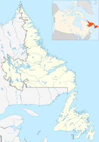
St. Andrew's is a local service district and designated place in the Canadian province of Newfoundland and Labrador. It is in the Codroy Valley in the southwestern corner of the island of Newfoundland.
Geography
St. Andrews is in Newfoundland within Subdivision A of Division No. 4.[1]
Demographics
As a designated place in the 2016 Census of Population conducted by Statistics Canada, St. Andrews recorded a population of 284 living in 136 of its 397 total private dwellings, a change of -6.3% from its 2011 population of 303. With a land area of 28.47 km2 (10.99 sq mi), it had a population density of 10.0/km2 (25.8/sq mi) in 2016.[2]
Government
St. Andrews is a local service district (LSD)[3] that is governed by a committee responsible for the provision of certain services to the community.[4] The chair of the LSD committee is Wilfred McIsaac.[3]
See also
- List of communities in Newfoundland and Labrador
- List of designated places in Newfoundland and Labrador
- List of local service districts in Newfoundland and Labrador
References
- ^ "Population and dwelling counts, for Canada, provinces and territories, census divisions, census subdivisions (municipalities) and designated places, 2016 and 2011 censuses – 100% data (Newfoundland and Labrador)". Statistics Canada. February 7, 2018. Retrieved December 23, 2021.
- ^ "Population and dwelling counts, for Canada, provinces and territories, and designated places, 2016 and 2011 censuses – 100% data (Newfoundland and Labrador)". Statistics Canada. February 7, 2018. Retrieved December 22, 2021.
- ^ a b "Directory of Local Service Districts" (PDF). Government of Newfoundland and Labrador. October 2021. Retrieved January 1, 2022.
- ^ "Local Service Districts – Frequently Asked Questions". Government of Newfoundland and Labrador. Retrieved January 1, 2022.
- v
- t
- e
subdivisions
places
- Barachois Brook
- Bay St. George South
- Benoits Siding
- Black Duck
- Black Duck Brook and Winterhouse
- Campbells Creek
- Flat Bay
- Fox Island River-Point au Mal
- Great Codroy
- Mainland
- Mattis Point
- Millville to Cape Anguille
- O'Regan's Central
- Piccadilly Head
- Piccadilly Slant-Abraham's Cove
- Searston
- Sheaves Cove
- Ship Cove-Lower Cove-Jerry's Nose
- St. Andrews
- St. Teresa
- Stephenville Crossing
- Three Rock Cove
- Tompkins
- Upper Ferry
- West Bay
communities
47°46′37″N 59°16′23″W / 47.777°N 59.273°W / 47.777; -59.273
 | This Newfoundland and Labrador location article is a stub. You can help Wikipedia by expanding it. |
- v
- t
- e


