National Register of Historic Places listings in Moffat County, Colorado
List of National Register of Historic Places in Moffat County, Colorado, United States

This is a list of the National Register of Historic Places listings in Moffat County, Colorado.
This is intended to be a complete list of the properties and districts on the National Register of Historic Places in Moffat County, Colorado, United States. The locations of National Register properties and districts for which the latitude and longitude coordinates are included below, may be seen in a map.[1]
There are 15 properties and districts listed on the National Register in the county.
This National Park Service list is complete through NPS recent listings posted June 14, 2024.[2]
- v
- t
- e
Properties on the National Register of Historic Places in Colorado by county
- Adams
- Alamosa
- Arapahoe
- Archuleta
- Baca
- Bent
- Boulder
- Broomfield
- Chaffee
- Cheyenne
- Clear Creek
- Conejos
- Costilla
- Crowley
- Custer
- Delta
- Denver
- Dolores
- Douglas
- Eagle
- El Paso
- Elbert
- Fremont
- Garfield
- Gilpin
- Grand
- Gunnison
- Hinsdale
- Huerfano
- Jackson
- Jefferson
- Kiowa
- Kit Carson
- La Plata
- Lake
- Larimer
- Las Animas
- Lincoln
- Logan
- Mesa
- Mineral
- Moffat
- Montezuma
- Montrose
- Morgan
- Otero
- Ouray
- Park
- Phillips
- Pitkin
- Prowers
- Pueblo
- Rio Blanco
- Rio Grande
- Routt
- Saguache
- San Juan
- San Miguel
- Sedgwick
- Summit
- Teller
- Washington
- Weld
- Yuma

Map all coordinates using OpenStreetMap
Download coordinates as:
- KML
- GPX (all coordinates)
- GPX (primary coordinates)
- GPX (secondary coordinates)
Current listings
| [3] | Name on the Register[4] | Image | Date listed[5] | Location | City or town | Description |
|---|---|---|---|---|---|---|
| 1 | Bromide Charcoal Kilns |  | June 30, 2000 (#00000740) | Off County Road 10 40°34′39″N 108°39′24″W / 40.5775°N 108.656667°W / 40.5775; -108.656667 (Bromide Charcoal Kilns) | Greystone | |
| 2 | Castle Park Archeological District |  | January 3, 2006 (#06000055) | Address Restricted | Dinosaur | |
| 3 | Rial Chew Ranch Complex |  | October 27, 1987 (#86003392) | U.S. Highway 40 40°29′55″N 109°00′47″W / 40.498611°N 109.013056°W / 40.498611; -109.013056 (Rial Chew Ranch Complex) | Dinosaur | |
| 4 | Craig School #2 |  | April 4, 2023 (#100008788) | 775 Yampa Ave. 40°31′09″N 107°32′49″W / 40.519268°N 107.546840°W / 40.519268; -107.546840 (Craig School #2) | Craig | |
| 5 | First National Bank Building |  | July 17, 1997 (#97000793) | 502-506 Yampa Ave. 40°30′52″N 107°32′49″W / 40.514444°N 107.546944°W / 40.514444; -107.546944 (First National Bank Building) | Craig | |
| 6 | Denis Julien Inscription | Upload image | December 19, 1986 (#86003395) | U.S. Highway 40 40°32′43″N 109°00′55″W / 40.545278°N 109.015278°W / 40.545278; -109.015278 (Denis Julien Inscription) | Dinosaur | |
| 7 | Lay School |  | March 20, 2013 (#13000080) | 7 Eddy Ave. 40°31′39″N 107°52′55″W / 40.527501°N 107.881897°W / 40.527501; -107.881897 (Lay School) | Lay | |
| 8 | Mantle's Cave | Upload image | May 10, 1994 (#94000394) | Dinosaur National Monument 40°28′00″N 108°54′04″W / 40.466667°N 108.901111°W / 40.466667; -108.901111 (Mantle's Cave) | Dinosaur | |
| 9 | Marcia (Pullman car) |  | June 20, 1975 (#75000526) | 341 E. Victory Way 40°30′51″N 107°32′32″W / 40.514167°N 107.542222°W / 40.514167; -107.542222 (Marcia (Pullman car)) | Craig | |
| 10 | Old Ladore School |  | February 24, 1975 (#75000525) | By the Green River on State Highway 318 40°46′48″N 108°53′32″W / 40.78°N 108.892222°W / 40.78; -108.892222 (Old Ladore School) | Brown's Park | |
| 11 | State Armory |  | June 25, 1992 (#92000810) | 590 Yampa Ave. 40°30′57″N 107°32′49″W / 40.515833°N 107.546944°W / 40.515833; -107.546944 (State Armory) | Craig | Now the Museum of Northwest Colorado. |
| 12 | Two-Bar Ranch |  | February 17, 1978 (#78000873) | West of Maybell off State Highway 318 40°47′12″N 108°53′38″W / 40.786667°N 108.893889°W / 40.786667; -108.893889 (Two-Bar Ranch) | Maybell | |
| 13 | Upper Wade and Curtis Cabin |  | December 19, 1986 (#86003399) | U.S. Highway 40 40°43′38″N 108°52′33″W / 40.727222°N 108.875833°W / 40.727222; -108.875833 (Upper Wade and Curtis Cabin) | Dinosaur | |
| 14 | Vanatta Apartments | 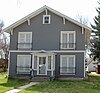 | January 11, 1996 (#95001511) | 660 Yampa Ave. 40°31′02″N 107°32′49″W / 40.517222°N 107.546944°W / 40.517222; -107.546944 (Vanatta Apartments) | Craig | |
| 15 | White-Indian Contact Site | Upload image | March 8, 1977 (#77001561) | Address Restricted | Sparks | 5MF605, also known as Fort Davy Crockett[6] |
See also
 History portal
 United States portal
 Colorado portal
 National Register of Historic Places portal


- List of National Historic Landmarks in Colorado
- List of National Register of Historic Places in Colorado
- Bibliography of Colorado
- Geography of Colorado
- History of Colorado
- Index of Colorado-related articles
- List of Colorado-related lists
- Outline of Colorado
References
- ^ The latitude and longitude information provided in this table was derived originally from the National Register Information System, which has been found to be fairly accurate for about 99% of listings. Some locations in this table may have been corrected to current GPS standards.
- ^ National Park Service, United States Department of the Interior, "National Register of Historic Places: Weekly List Actions", retrieved June 14, 2024.
- ^ Numbers represent an alphabetical ordering by significant words. Various colorings, defined here, differentiate National Historic Landmarks and historic districts from other NRHP buildings, structures, sites or objects.
- ^ "National Register Information System". National Register of Historic Places. National Park Service. July 9, 2010.
- ^ The eight-digit number below each date is the number assigned to each location in the National Register Information System database, which can be viewed by clicking the number.
- ^ https://www.fws.gov/mountain-prairie/refuges/documents/Browns%20Park%20%20-%20Fort%20Davy%20Crockett.pdf [bare URL PDF]
External links
Wikimedia Commons has media related to Moffat County, Colorado.
- State of Colorado
- History Colorado
- Moffat County, Colorado
| |
|---|---|
| Topics | |
| Lists by state |
|
| Lists by insular areas | |
| Lists by associated state | |
| Other areas | |
| Related | |
| |


Municipalities and communities of Moffat County, Colorado, United States | ||
|---|---|---|
County seat: Craig | ||
| City | 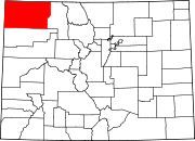 | |
| Town | ||
| CDP | ||
| Unincorporated communities | ||
| Ghost towns | ||
| ||
| |
|---|---|
Denver (capital) | |
| Topics |
|
| Society | |
| Cities |
|
| Counties |
|
| Regions |
|
 Colorado portal Colorado portal | |
| |||||||||||||||||||||||||||||||||
|---|---|---|---|---|---|---|---|---|---|---|---|---|---|---|---|---|---|---|---|---|---|---|---|---|---|---|---|---|---|---|---|---|---|
| Federal |
| ||||||||||||||||||||||||||||||||
| State |
| ||||||||||||||||||||||||||||||||
| Trails |
| ||||||||||||||||||||||||||||||||
40°37′07″N 108°12′27″W / 40.6187°N 108.2075°W / 40.6187; -108.2075 (Moffat County, Colorado)


