National Register of Historic Places listings in Hinsdale County, Colorado
List of National Register of Historic Places in Hinsdale County, Colorado, United States
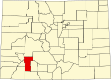
This is a list of the National Register of Historic Places listings in Hinsdale County, Colorado.
This is intended to be a complete list of the properties and districts on the National Register of Historic Places in Hinsdale County, Colorado, United States. The locations of National Register properties and districts for which the latitude and longitude coordinates are included below, may be seen in a map.[1]
There are 12 properties and districts listed on the National Register in the county.
This National Park Service list is complete through NPS recent listings posted June 14, 2024.[2]
- v
- t
- e
Properties on the National Register of Historic Places in Colorado by county
- Adams
- Alamosa
- Arapahoe
- Archuleta
- Baca
- Bent
- Boulder
- Broomfield
- Chaffee
- Cheyenne
- Clear Creek
- Conejos
- Costilla
- Crowley
- Custer
- Delta
- Denver
- Dolores
- Douglas
- Eagle
- El Paso
- Elbert
- Fremont
- Garfield
- Gilpin
- Grand
- Gunnison
- Hinsdale
- Huerfano
- Jackson
- Jefferson
- Kiowa
- Kit Carson
- La Plata
- Lake
- Larimer
- Las Animas
- Lincoln
- Logan
- Mesa
- Mineral
- Moffat
- Montezuma
- Montrose
- Morgan
- Otero
- Ouray
- Park
- Phillips
- Pitkin
- Prowers
- Pueblo
- Rio Blanco
- Rio Grande
- Routt
- Saguache
- San Juan
- San Miguel
- Sedgwick
- Summit
- Teller
- Washington
- Weld
- Yuma

Map all coordinates using OpenStreetMap
Download coordinates as:
- KML
- GPX (all coordinates)
- GPX (primary coordinates)
- GPX (secondary coordinates)
Current listings
| [3] | Name on the Register[4] | Image | Date listed[5] | Location | City or town | Description |
|---|---|---|---|---|---|---|
| 1 | Argentum Mining Camp |  | September 28, 1999 (#99001235) | Address Restricted | Lake City | Burrows Park, Alpine Loop National Back Country Byway |
| 2 | Capitol City Charcoal Kilns |  | September 28, 1999 (#99001236) | Address Restricted | Lake City | |
| 3 | Debs School |  | April 28, 2005 (#05000338) | 2783 McManus Rd. 37°26′16″N 107°09′42″W / 37.437778°N 107.161667°W / 37.437778; -107.161667 (Debs School) | Pagosa Springs | |
| 4 | Empire Chief Mine and Mill |  | September 28, 1999 (#99001237) | Address Restricted | Lake City | Last standing building collapsed, winter 2007/2008 |
| 5 | Golconda Mine |  | September 28, 1999 (#99001234) | Address Restricted | Lake City | |
| 6 | Lake City Historic District |  | December 1, 1978 (#78000859) | Roughly bounded by Bluff, 8th, Lake, and 1st Streets 38°01′46″N 107°18′58″W / 38.029444°N 107.316111°W / 38.029444; -107.316111 (Lake City Historic District) | Lake City | May-Bardwell-Heath house, 1891, in historic district |
| 7 | Little Rome | Upload image | September 28, 1999 (#99001233) | Address Restricted | Lake City | |
| 8 | Lost Trail Station |  | April 27, 2011 (#11000219) | 81125 Forest Service Road 520 37°46′08″N 107°21′45″W / 37.768896°N 107.362521°W / 37.768896; -107.362521 (Lost Trail Station) | Creede | |
| 9 | Rose Lime Kiln |  | April 8, 1993 (#93000293) | County Road 20 southwest of Lake City 37°58′23″N 107°31′24″W / 37.973056°N 107.523333°W / 37.973056; -107.523333 (Rose Lime Kiln) | Lake City | |
| 10 | Tellurium-White Cross Mining Camp | Upload image | September 28, 1999 (#99001232) | Address Restricted | Lake City | |
| 11 | Tobasco Mine and Mill |  | October 16, 2008 (#08000983) | South of San Juan County Road 5 and Hinsdale County Road 34 37°55′50″N 107°32′08″W / 37.93052°N 107.535644°W / 37.93052; -107.535644 (Tobasco Mine and Mill) | Lake City | Listed as part of Hinsdale Metal Mining MPS; extends into San Juan County |
| 12 | Ute-Ulay Mine and Mill |  | October 26, 2017 (#100001755) | County Road 20 38°01′11″N 107°22′35″W / 38.019735°N 107.376370°W / 38.019735; -107.376370 (Ute-Ulay Mine and Mill) | Lake City |
See also
 History portal
 United States portal
 Colorado portal
 National Register of Historic Places portal


- List of National Historic Landmarks in Colorado
- List of National Register of Historic Places in Colorado
- Bibliography of Colorado
- Geography of Colorado
- History of Colorado
- Index of Colorado-related articles
- List of Colorado-related lists
- Outline of Colorado
References
- ^ The latitude and longitude information provided in this table was derived originally from the National Register Information System, which has been found to be fairly accurate for about 99% of listings. Some locations in this table may have been corrected to current GPS standards.
- ^ National Park Service, United States Department of the Interior, "National Register of Historic Places: Weekly List Actions", retrieved June 14, 2024.
- ^ Numbers represent an alphabetical ordering by significant words. Various colorings, defined here, differentiate National Historic Landmarks and historic districts from other NRHP buildings, structures, sites or objects.
- ^ "National Register Information System". National Register of Historic Places. National Park Service. July 9, 2010.
- ^ The eight-digit number below each date is the number assigned to each location in the National Register Information System database, which can be viewed by clicking the number.
External links
Wikimedia Commons has media related to Hinsdale County, Colorado.
- State of Colorado
- History Colorado
- Hinsdale County, Colorado
| |
|---|---|
| Topics | |
| Lists by state |
|
| Lists by insular areas | |
| Lists by associated state | |
| Other areas | |
| Related | |
| |


Municipalities and communities of Hinsdale County, Colorado, United States | ||
|---|---|---|
County seat: Lake City | ||
| Town |  | |
| CDPs | ||
| Ghost town | ||
| ||
| |
|---|---|
Denver (capital) | |
| Topics |
|
| Society | |
| Cities |
|
| Counties |
|
| Regions |
|
 Colorado portal Colorado portal | |
| |||||||||||||||||||||||||||||||||
|---|---|---|---|---|---|---|---|---|---|---|---|---|---|---|---|---|---|---|---|---|---|---|---|---|---|---|---|---|---|---|---|---|---|
| Federal |
| ||||||||||||||||||||||||||||||||
| State |
| ||||||||||||||||||||||||||||||||
| Trails |
| ||||||||||||||||||||||||||||||||
37°49′15″N 107°18′01″W / 37.8208°N 107.3004°W / 37.8208; -107.3004 (Hinsdale County, Colorado)


