Nuneaton en Bedworth
Niet-metropolitaans district in Engeland  | |||
|---|---|---|---|
  | |||
| Situering | |||
| Land | Engeland | ||
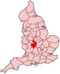
| County | Warwickshire | ||
| Regio | West Midlands | ||
| Coördinaten | 52°31'18"NB, 1°28'3"WL | ||
| Algemeen | |||
| Oppervlakte | 78,9504[1] km² | ||
| Inwoners (2018[2]) | 128.902 (1633 inw./km²) | ||
| ONS-code | E07000219 | ||
| Detailkaart | |||
 | |||
| |||

Nuneaton en Bedworth is een Engels district in het shire-graafschap (non-metropolitan county OF county) Warwickshire en telt 129.000 inwoners. De oppervlakte bedraagt 79 km².
Van de bevolking is 14,8% ouder dan 65 jaar. De werkloosheid bedraagt 2,9% van de beroepsbevolking (cijfers volkstelling 2001).
Plaatsen in het district Nuneaton en Bedworth
- Bedworth
- Bulkington
- Nuneaton
Partnersteden
 Guadalajara, Spanje sinds 1990

Bronnen, noten en/of referenties
- ↑ Office for National Statistics → Download → SAM_for_Administrative_Areas_(2018).zip → SAM_LAD_DEC_2018_UK.xlsx.
- ↑ https://www.ons.gov.uk/file?uri=/peoplepopulationandcommunity/populationandmigration/populationestimates/datasets/populationestimatesforukenglandandwalesscotlandandnorthernireland/mid20182019laboundaries/ukmidyearestimates20182019ladcodes.xls Schatting Office for National Statistics: knop MYE5 → kolom Estimated Population mid-2018]
- Volkstelling 2001, Office for National Statistics


