ニューヨーク=ニュージャージー港河口の地理
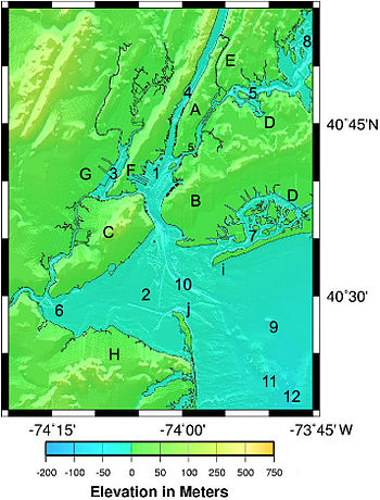
2. ロウワー・ニューヨーク湾
3. ニューアーク湾 (en)
4. ハドソン川
5. イースト川
6. ラリタン湾 (en)
7. ジャマイカ湾 (en)
8. ロングアイランド湾
9. ニューヨーク湾入部 (en) - 北大西洋
10. アンブローズ水路 (en)
11. Sludge Dumping Site
12. ハドソン海底谷 (en)
A. マンハッタン
B. ブルックリン
C. スタテン・アイランド
D. クイーンズ
E. ブロンクス
F. ベイヨン-ジャージーシティ
G. ニューアーク
H. ラリタン湾岸 (en)
i. ロッカウェイ・ポイント (en)
j. サンディ・フック (en)
ニューヨーク州とニュージャージー州の港湾 (en) の水路系は世界でも有数の入り組んだ自然港を形成している。この港周辺の地形は多様性に富んでいるため、関連する地名も多様にある。大まかな地形はジョバンニ・ダ・ヴェラッツァーノが1524年にヨーロッパ人として初めてこの水域にたどり着いたときからほとんど変わってはいないが、手つかずの自然はもはや残されていない。ヘルゲート (en) やエリス島などのエリアはほとんどが人工的な改変が加えられている。目に見えない大きな改変としては航行用の水路は自然の17フィート (5.2 m)の深さを45フィート (14 m)に拡張し、基盤岩を爆破しなければならない箇所もあった。
この港湾は三つの主要水系が合流する地点に横たわっている。この港湾の南東はニューヨーク湾入部 (en) (大西洋)に、北東はロングアイランド湾に開いている。これらの両方は基本的に潮汐と塩水を備えた海洋の一部であるが、ロングアイランド湾は河口なので大西洋と比べて約20-30%塩分が少なく、潮汐は3時間遅く最大70%大きく変動する。ハドソン川はより淡水に近く、北からの潮の流れはないが、潮汐と汽水域はハドソン川まで広がっている。
これらの三つ(ニューヨーク湾入部・ロングアイランド湾・ハドソン川)が組み合わさって、オールバニからモントーク (en) そしてニューヨーク湾入部のハドソン海底谷 (en) の海域までの水圏に渡って、潮汐と流れの極度に複雑な水系を作り上げている[1]。ニューヨーク港観測・予測システム (New York Harbor Observing and Prediction System, NYHOPS) はセンサー、天気予報そして環境モデルの情報を用いてこの領域の稀少・海洋状況をリアルタイムで予測している。
港湾の地物
以下にニューヨーク州とニュージャージー州の港湾 (en) の地物を天然の地物から順に記載する。この一覧ではロウワー・ニューヨーク湾からおおよそ時計回りに列挙する。法的区域によっても分類する。
公式の参考文献は、NOAA沿岸案内[2]、NOAA海図[3]、そしてUSGS地形図[4] である。多くの法的地域の区分はアメリカの法律に則っている[5]。
川・水路
|
|
海峡
|
|
湾・小湾・入り江
|
|
|
島
ニュージャージー州
- ロビンス礁 (Robbins Reef)
- Plum Island, Sandy Hook Bay
- エリス島[注釈 1]
- シューターズ島 (Shooters Island)
- リバティ島、ニュージャージー州に囲まれたニューヨーク州の包領
ニューヨーク州
ジャマイカ湾の島
アッパー・ニューヨーク湾の島 イースト川の島 | ジャマイカ湾の島
|
陸の地物
|
|
堆・浅瀬・岩棚・岩礁
|
|
|
航行水路
|
|
|
港湾施設
ニューヨーク・ニュージャージー港湾公社の責務の一つはニューヨーク=ニュージャージーエリアの懲役を促進することである。ポートオーソリティはこの一覧に記載するコンテナ施設の多くを運用しており、アメリカ陸軍工兵司令部と協業してこの港湾の水路を維持管理している。
- ニュージャージー州
私企業によって運用されている石油タンク等の貨物施設は記載していない
- ポート・ジャージー (Port Jersey)
- Global Marine Terminal, ジャージーシティ— 私営
- Auto Marine Terminal, ベイヨンおよびジャージーシティ— ポートオーソリティ
- ポート・ニューアーク=エリザベス・マリン・ターミナル (Port Newark-Elizabeth Marine Terminal), ニューアークとエリザベス— ポートオーソリティ
- ニューヨーク州
- ブルックリン
- Red Hook Container Terminal— ポートオーソリティ
- サウス・ブルックリン・マリン・ターミナル (South Brooklyn Marine Terminal)— ニューヨーク市
- スタテン・アイランド
- ハウランド・フック・マリン・ターミナル (Howland Hook Marine Terminal)— ポートオーソリティ
灯台
[7] および[8] を参照のこと。但し書きがなければ現在も運用中である。
|
|
臨海部区域
政府および他の組織
- ニューヨーク・ニュージャージー港湾公社
- 港湾委員会 (Waterfront Commission)
- アメリカ陸軍工兵司令部
- アメリカ沿岸警備隊
- アメリカ合衆国公園警察 (United States Park Police)
- アメリカ合衆国税関・国境警備局
- 入国・税関管理局 (Immigration and Customs Enforcement)
- アメリカ合衆国国立公園局
- ニュージャージー牧草地委員会 (New Jersey Meadowlands Commission)
州・郡・市
|
|
脚注
[脚注の使い方]
注釈
- ^ a b c エリス島の1834年から始まった全ての埋め立て地帯はハドソン郡に所属する。リバティ島とエリス島を取り巻く水域はハドソン郡に所属する。
- ^ 区の境界は、西はハドソン川中央、南はガバナーズ島の南の港湾、東はイースト川の埠頭の先、北はハーレム川とスパイテン・ダイヴィル川である。例外はマーブル・ヒル (Marble Hill) のエリアで、スパイテン・ダイヴィル川より北の対岸に位置している。(ブロンクス区とのおおよその境界は Johnson AvenueとWest 230 Streetである。)またリバティ島とエリス島は1834年の埋め立て前の領土部分のみがマンハッタン区に属する。
出典
- ^ NOAA Tides and Current web site FAQ page. See discussion of hydraulic currents [1]
- ^ Chapter 11, New York Harbor and Approaches, Coast Pilot 2, 35th Edition, 2006, Office of Coast Survey, NOAA.
- ^ NOAA nautical charts 12327[リンク切れ] New York Harbor (1:40,000 scale), 12324[リンク切れ] Sandy Hook to Little Egg, 12350[リンク切れ] Jamaica Bay and Rockaway Inlet, 12402[リンク切れ], 12401[リンク切れ] New York Lower Bay, 12331[リンク切れ] Raritan Bay and southern part of Arthur Kill, 12332[リンク切れ] Raritan River, 12333[リンク切れ] Kill van Kull and northern part of Arthur Kill, 12334[リンク切れ] New York Harbor (Upper Bay and Narrows, 12337[リンク切れ], 12335[リンク切れ], 12338[リンク切れ], 12341 Archived 2007年9月26日, at the Wayback Machine., 12339 Archived 2007年9月26日, at the Wayback Machine., 12366 Archived 2007年9月26日, at the Wayback Machine. Long Island Sound and East River, found on page Nautical charts Atlantic Coast charts online Archived 2006年9月2日, at the Wayback Machine., Office of Coast Survey, NOAA.
- ^ USGS topographic maps, 1:24,000 scale, listed from west to east (in a row), then north to south:
- Yonkers, Mount Vernon, Mamaroneck;
- Orange, Weehawken, Central Park Flushing, Seacliff;
- Elizabeth, Jersey City, Brooklyn, Jamaica, Lynbrook;
- Perth Amboy, Arthur Kill The Narrows, Coney Island, Far Rockaway;
- South Amboy, Keyport, Sandy Hook West, Sandy Hook East.
- ^ Title 33.Navigation And Navigable Waters Archived 2006年9月26日, at the Wayback Machine. USC. See Section 59.
- ^ Reports of Channel Conditions Archived 2008年10月29日, at the Wayback Machine., USACE, Nov. 2004: "Partial Anchorage Channel:Starts approximately 3,990 Ft. seaward of Red Gas #2; Ends approximately 1,660 Ft. landward of Red Light & Bell #21. Authorized project: Width: 2000 ft, Length: 2.34 nmiles, Depth 45 ft.... Shoaling exists and begins approximately 2,230 Ft. seaward of Red Gas #2 and proceeds landward with a length of approximately 600 Ft. and a width of approximately 60 Ft." Also Hearing Notice for Department of the Army Corps of Engineers, N.Y.S. Department of Environmental Conservation 21/1/2004. Simplified map Bayonne Peninsula Chap. 6, CPIP Toolkit, PANYNJ.
- ^ of Historic Light Stations New Jersey Lighthouses & Inventory of Historic Light Stations New York Lighthouses NPS lists.
- ^ New York Lighthouses & New York Lighthouses Lighthouse Friends 2001-2005.
関連項目
- ニューヨーク=ニュージャージー港河口の海洋生物 (en)
- ニューアーク盆地 (Newark Basin)
- ニューヨーク港
外部リンク
- New York-New Jersey Harbor Estuary Program 港河口の保全と復元のための組合
- New York and New Jersey Harbor US Army Corps of Engineers: NY/NJ Harbor
- PANJNY Coastal Ecosystems Initiatives
- “How The Earth Was Made”. © 1996-2011, A&E Television Networks, LLC. All Rights Reserved. 2011年9月19日閲覧。 河口の形成を説明している動画
- ニューヨークの地理 ニューヨーク州からニューヨーク市(区)までの地理を日本語で説明


