Brentwood (New Hampshire)
Pour les articles homonymes, voir Brentwood.

Cet article est une ébauche concernant une localité du New Hampshire.
Vous pouvez partager vos connaissances en l’améliorant (comment ?) selon les recommandations des projets correspondants.
Brentwood

| Pays |  États-Unis États-Unis |
|---|---|
| État | New Hampshire |
| Comté | comté de Rockingham (siège) |
| Superficie | 44 km2 |
| Surface en eau | 0 % |
| Altitude | 35 m |
| Coordonnées | 42° 58′ 43″ N, 71° 04′ 22″ O |
| Population | 4 490 hab. () |
|---|---|
| Densité | 102 hab./km2 () |
| Statut | Town de Nouvelle-Angleterre (en), siège de comté |
|---|
| Fondation | |
|---|
| Code postal | 03833 |
|---|---|
| Code FIPS | 33-07220 |
| GNIS | 873550 |
| TGN | 2063262 |
| Indicatif téléphonique | 603 |
| Site web | (en) www.brentwoodnh.gov |

modifier - modifier le code - modifier Wikidata
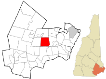
La ville de Brentwood est située dans l’État du New Hampshire, aux États-Unis. Elle est l’un des deux sièges du comté de Rockingham avec la ville d’Exeter. Sa population s’élevait à 4 486 habitants lors du recensement de 2010, estimée à 4 680 habitants en 2017.
Démographie
| Historique des recensements | |||
| Ann. | Pop. | %± | |
|---|---|---|---|
| 1790 | 976 | — | |
| 1800 | 899 | ▼ −7,89 % | |
| 1810 | 905 | ▲ +0,67 % | |
| 1820 | 892 | ▼ −1,44 % | |
| 1830 | 891 | ▼ −0,11 % | |
| 1840 | 888 | ▼ −0,34 % | |
| 1850 | 923 | ▲ +3,94 % | |
| 1860 | 887 | ▼ −3,9 % | |
| 1870 | 895 | ▲ +0,9 % | |
| 1880 | 999 | ▲ +11,62 % | |
| 1890 | 967 | ▼ −3,2 % | |
| 1900 | 957 | ▼ −1,03 % | |
| 1910 | 759 | ▼ −20,69 % | |
| 1920 | 685 | ▼ −9,75 % | |
| 1930 | 725 | ▲ +5,84 % | |
| 1940 | 720 | ▼ −0,69 % | |
| 1950 | 819 | ▲ +13,75 % | |
| 1960 | 1 072 | ▲ +30,89 % | |
| 1970 | 1 468 | ▲ +36,94 % | |
| 1980 | 2 004 | ▲ +36,51 % | |
| 1990 | 2 590 | ▲ +29,24 % | |
| 2000 | 3 197 | ▲ +23,44 % | |
| 2010 | 4 486 | ▲ +40,32 % | |
| Est. 2017 | 4 680 | ||
Liens externes
- Ressource relative à la géographie
 :
: - Geographic Names Information System
- (en) Site officiel
v · m | |
|---|---|
|

 Portail du New Hampshire


