Alvdal

Cet article est une ébauche concernant une localité norvégienne.
Vous pouvez partager vos connaissances en l’améliorant (comment ?) selon les recommandations des projets correspondants.
| Alvdal | |
 Héraldique | |
 Vue aérienne d'Alvdal. | |
| Administration | |
|---|---|
| Pays |  Norvège Norvège |
| Région | Østlandet |
| Comté | Innlandet |
| Centre administratif | Alvdal |
| Maire | Mona Murud (d) (Parti du centre) |
| Démographie | |
| Gentilé | Alvdøl, vetlelvdøl |
| Population | 2 493 hab. () |
| Densité | 2,6 hab./km2 |
| Géographie | |
| Coordonnées | 62° 06′ 34″ nord, 10° 38′ 04″ est |
| Altitude | Max. 1 826,95 m m (Storsølnkletten (en)) |
| Superficie | 94 215 ha = 942,15 km2 |
| Divers | |
| Langue officielle | Neutre |
| Localisation | |
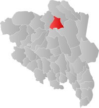 Localisation d'Alvdal dans le comté d'Innlandet | |
modifier  | |


Alvdal est une commune norvégienne située dans le comté d'Innlandet. Elle fait partie de la région de Østerdalen.
Géographie

La commune s'étend sur 942,15 km2 dans le nord du comté. Son territoire principalement montagneux culmine à 1 827 m au Storsølnkletten.
Communes limitrophes
 | Folldal | Tynset | Tynset | |
| Folldal | N | Rendalen | ||
| O Alvdal E | ||||
| S | ||||
| Stor-Elvdal | Stor-Elvdal | Rendalen |
Transports
La commune est desservie par une gare de la ligne de Røros.
Notes et références

Cette section est vide, insuffisamment détaillée ou incomplète. Votre aide est la bienvenue ! Comment faire ?

 Portail de la Norvège


