Yanahuanca District
District in Pasco, Peru
Yanahuanca Yanawanka | |
|---|---|
District | |
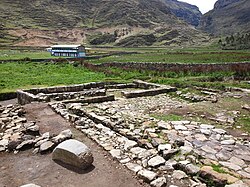 Warmiwasi, part of the archaeological site of Warawtampu in the Yanahuanca District | |
| 10°29′29″S 76°30′49″W / 10.49139°S 76.51361°W / -10.49139; -76.51361 | |
| Country |  Peru Peru |
| Region | Pasco |
| Province | Daniel Alcides Carrión |
| Capital | Yanahuanca |
| Government | |
| • Mayor | Juan Luis Chombo Heredia (2019-2022) |
| Area | |
| • Total | 923.48 km2 (356.56 sq mi) |
| Elevation | 3,184 m (10,446 ft) |
| Population (2017) | |
| • Total | 11,333 |
| • Density | 12/km2 (32/sq mi) |
| Time zone | UTC-5 (PET) |
| Geocode | 190201 |
Yanahuanca District is one of eight districts of the Daniel Alcides Carrión Province in the mountains of central Peru.[1]
Geography
The Rawra mountain range traverses the district. Some of the highest mountains of the district are listed below:[2]
- Ana Maray
- Atalaya
- Chakraqucha
- Challwayuq
- Chunta
- Ch'uspi
- Hanka Pata
- Hatun Punta
- Iskuqucha
- Kiswar
- Kunkayuq
- Kushurupata
- Paqush
- Parya Chuku
- Puka Mach'ay
- Puma Ratashqa
- Pumaqucha
- Punta Ch'aqra
- Puywanqucha
- Phiruru
- Qullpapata
- Qutuq
- Qhuna Pirwa
- Q'illay Hanka
- Racha Kancha
- Rat'a Thapa
- Ruphaq
- Saqra Mach'ay
- Tuku Mach'ay
- Turi Hanka
- Wacha
- Wanchaq
- Warmi Wañusqa
- Waswa Qaqa
- Yana Chaka
- Yana Uqhu
- Yanta Hirka
Climate
| Climate data for Yanahuanca, elevation 3,137 m (10,292 ft), (1991–2020) | |||||||||||||
|---|---|---|---|---|---|---|---|---|---|---|---|---|---|
| Month | Jan | Feb | Mar | Apr | May | Jun | Jul | Aug | Sep | Oct | Nov | Dec | Year |
| Mean daily maximum °C (°F) | 19.8 (67.6) | 19.6 (67.3) | 19.4 (66.9) | 20.2 (68.4) | 21.0 (69.8) | 21.3 (70.3) | 21.0 (69.8) | 21.2 (70.2) | 20.7 (69.3) | 20.6 (69.1) | 20.9 (69.6) | 19.8 (67.6) | 20.5 (68.8) |
| Mean daily minimum °C (°F) | 7.8 (46.0) | 8.0 (46.4) | 8.1 (46.6) | 7.8 (46.0) | 7.2 (45.0) | 6.5 (43.7) | 6.0 (42.8) | 6.3 (43.3) | 7.2 (45.0) | 7.5 (45.5) | 7.7 (45.9) | 7.8 (46.0) | 7.3 (45.2) |
| Average precipitation mm (inches) | 108.2 (4.26) | 100.3 (3.95) | 123.9 (4.88) | 66.4 (2.61) | 28.8 (1.13) | 11.8 (0.46) | 13.1 (0.52) | 11.5 (0.45) | 29.3 (1.15) | 62.1 (2.44) | 78.0 (3.07) | 101.4 (3.99) | 734.8 (28.91) |
| Source: National Meteorology and Hydrology Service of Peru[3] | |||||||||||||
See also
- Daniel Alcides Carrión
- Pukamayu
- Warawtampu
References
- ^ (in Spanish) Instituto Nacional de Estadística e Informática. Banco de Información Distrital. Retrieved April 11, 2008.
- ^ escale.minedu.gob.pe - UGEL map of the Daniel Alcides Carrión Province (Huánuco Region)
- ^ "Normales Climáticas Estándares y Medias 1991-2020". National Meteorology and Hydrology Service of Peru. Archived from the original on 21 August 2023. Retrieved 17 June 2024.

 | This Pasco Region geography article is a stub. You can help Wikipedia by expanding it. |
- v
- t
- e


