Wrestedt
Municipality in Lower Saxony, Germany

Flag

Coat of arms
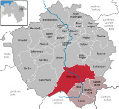
Location of Wrestedt within Uelzen district
52°54′N 10°35′E / 52.900°N 10.583°E / 52.900; 10.583
(2022-12-31)[1]
29559
Wrestedt is a municipality in the district of Uelzen, in Lower Saxony, Germany. It is situated approximately 7 km south of Uelzen. Wrestedt is the seat of the Samtgemeinde ("collective municipality") Aue, which consists of the municipalities Bad Bodenteich, Lüder, Soltendieck, and Wrestedt.

References
- ^ "LSN-Online Regionaldatenbank, Tabelle A100001G: Fortschreibung des Bevölkerungsstandes, Stand 31. Dezember 2022" (in German). Landesamt für Statistik Niedersachsen.
External links
- Village website
- v
- t
- e
Towns and municipalities in Uelzen (district)

Authority control databases | |
|---|---|
| International |
|
| National |
|
| Geographic |
|
 | This Uelzen (district) location article is a stub. You can help Wikipedia by expanding it. |
- v
- t
- e


