Talkha
City in Dakahlia, Egypt
Talkha طلخا | |
|---|---|
 Talkha (right) and Mansoura (left) | |
| 31°03′17″N 31°22′32″E / 31.054735°N 31.375644°E / 31.054735; 31.375644 | |
| Country |  Egypt Egypt |
| Governorate | Dakahlia |
| Area | |
| • Total | 157.0 km2 (60.6 sq mi) |
| Elevation | 18 m (59 ft) |
| Population (2021)[1] | |
| • Total | 413,584 |
| • Density | 2,600/km2 (6,800/sq mi) |
| Time zone | UTC+2 (EET) |
| Postal code | 35111 |
| Area code | 50 |
Talkha (Arabic: طلخا pronounced [ˈtˤɑlxɑ]) is a city in Dakahlia Governorate, Egypt. The city is located on the west bank of the Damietta,[2] a distributary of the Nile in the Delta region. Is about 120 km northeast of Cairo. Talkha is situated opposite the city of Mansoura on the Damietta. Together, the two cities form an agglomeration.
Talkha contains the neighborhoods of Old Market, El Maalamein, Ar Rouda, El Sharifa, and El Muhandisin.

Roads in Talkha
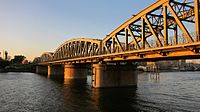
Railway bridge between Talkha and Mansoura
Geography
Climate
Talkha is classified within the Köppen climate classification system as a hot desert (BWh).
| Climate data for Talkha | |||||||||||||
|---|---|---|---|---|---|---|---|---|---|---|---|---|---|
| Month | Jan | Feb | Mar | Apr | May | Jun | Jul | Aug | Sep | Oct | Nov | Dec | Year |
| Mean daily maximum °C (°F) | 18.9 (66.0) | 19.8 (67.6) | 22.4 (72.3) | 26.3 (79.3) | 32 (90) | 33 (91) | 32.7 (90.9) | 33.3 (91.9) | 32 (90) | 27.5 (81.5) | 25 (77) | 20.6 (69.1) | 27.0 (80.6) |
| Daily mean °C (°F) | 12.8 (55.0) | 13.5 (56.3) | 15.8 (60.4) | 19.1 (66.4) | 23.6 (74.5) | 25.7 (78.3) | 26.7 (80.1) | 26.9 (80.4) | 25.3 (77.5) | 22.8 (73.0) | 19.4 (66.9) | 14.8 (58.6) | 20.5 (69.0) |
| Mean daily minimum °C (°F) | 6.8 (44.2) | 7.3 (45.1) | 9.2 (48.6) | 11.9 (53.4) | 15.2 (59.4) | 18.4 (65.1) | 20.7 (69.3) | 20.5 (68.9) | 18.7 (65.7) | 17 (63) | 13.9 (57.0) | 9.1 (48.4) | 14.1 (57.3) |
| Average precipitation mm (inches) | 13 (0.5) | 9 (0.4) | 6 (0.2) | 4 (0.2) | 3 (0.1) | 0 (0) | 0 (0) | 0 (0) | 0 (0) | 4 (0.2) | 7 (0.3) | 11 (0.4) | 57 (2.3) |
| Source: Climate-Data.org[3] | |||||||||||||
See also
 Egypt portal

References
- ^ a b "Ṭalkhā (Markaz, Egypt) - Population Statistics, Charts, Map and Location". www.citypopulation.de. Retrieved 18 March 2023.
- ^ "Map of Talkha". Dakahliya Governorate site.
- ^ "Climate: Talkha - Climate graph, Temperature graph, Climate table". Climate-Data.org. Archived from the original on 2015-02-24. Retrieved 13 August 2013.
- v
- t
- e
Egyptian cities and towns by population- 6th of October
- Arish
- Aswan
- Benha
- Beni Suef
- Damanhur
- Desouk
- Edfu
- Hurghada
- Kafr El Dawwar
- Kafr El Sheikh
- Mallawi
- Minya
- New Borg El Arab
- New Cairo
- Obour
- Qena
- Shibin El Kom
- Sohag


