Taieri River
River in New Zealand
45°42′39″S 169°41′38″E / 45.71073°S 169.69397°E / -45.71073; 169.69397
• location
• coordinates
• elevation
The Taieri River (a misspelling of the original Māori name Taiari [1]) is the fourth-longest river in New Zealand and is in Otago in the South Island.[2] Rising in the Lammerlaw Range, it initially flows north, then east around the Rock and Pillar range before turning southeast, reaching the sea 30 kilometres (19 mi) south of Dunedin.
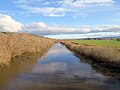
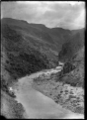
The upper reaches meander in a series of convoluted loops across a floodplain above Paerau, close to the aptly named locality of Serpentine; the river has created many small oxbow lakes in this area, some of which have been converted into water meadows. From here the river runs through two small hydroelectric power stations before reaching Patearoa in The Maniototo. The Taieri then arcs through almost 180 degrees, entering a broad glacial valley (the Strath-Taieri) surrounded by rugged hill ranges. Immediately downstream the river has cut a steep-sided declivity, the Taieri Gorge. This is known for the Taieri Gorge Railway, which follows a route into Central Otago through it. In the Taieri's lower reaches there is a broad floodplain (the Taieri Plains) containing much of Otago's most fertile farmland. The river then flows through the lower Taieri Gorge to the Pacific Ocean at Taieri Mouth. Taieri Island lies in the Pacific Ocean several hundred metres from the mouth of the river.[3]
The Taieri is 288 kilometres (179 mi) long, of which the last 20 kilometres (12 mi) are navigable. Despite its length the Taieri has a minimal amount of water volume compared to other New Zealand rivers with its average discharge being around 35 cubic metres per second (1,200 cu ft/s).[4] Towns along the river include Middlemarch, Outram, Allanton, Mosgiel, Henley, and Taieri Mouth. Its major tributary is the Waipori River, which meets the Taieri near Henley on the Taieri Plains. Google Maps erroneously shows the stretch of the river from the confluence to the mouth as Waipori River.[5] The official correct name is shown on the New Zealand government's official NZ Topo Map.[6]
However, while Taieri is the official name of the river, this name is known to be a misspelling of the Te Reo Māori word Taiari, meaning spring tide or shining water.[7][8][9]
Gallery
-
 The Taieri River at Allanton
 -
 Section of Taieri River and adjacent railway line circa 1926
 -
 Hyde-Macraes Bridge
 -
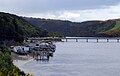 Taieri Mouth Bridge
 -
 Taieri Island / Moturata, offshore from the mouth of the Taieri River


References
- ^ [1]
- ^ The Swim Guide
- ^ Taieri River flows over weekend exceeded 1980 flood New Zealand Herald Retrieved 28 July 2017
- ^ "Taieri River at Outram Water Quantity". Land, Air, Water Aotearoa (LAWA). Retrieved 6 March 2023.
- ^ "Google Maps".
- ^ "New Zealand Topographic Map - NZ Topo Map".
- ^ [2]
- ^ [3]
- ^ [4]
External links
Wikimedia Commons has media related to Taieri River.
- Taieri River at Te Ara - The Encyclopedia of New Zealand
- v
- t
- e
Taieri River
Source: Lammerlaw Range. Flows into: Pacific Ocean
- Sutton Salt Lake
- Lake Mahinerangi
- Lake Waihola
- Lake Waipori
- Lake Tatawai (former lake)
Authority control databases | |
|---|---|
| International |
|
| National |
|


