San Bartolomé, Las Palmas
Municipality in Canary Islands, Spain
Flag

Coat of arms
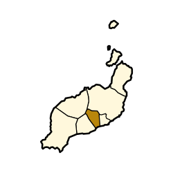
Municipal location in Lanzarote
29°0′6″N 13°36′42″W / 29.00167°N 13.61167°W / 29.00167; -13.61167
 Spain
Spain Canary Islands
(AMSL)
(2019)[1]
35550


San Bartolomé (Spanish meaning Saint Bartholomew) is a town and municipality in the Canary Islands (Spain) situated in the centre of the island of Lanzarote. The municipality of San Bartolomé stretches to the southeastern coast of the island.
It has an area of 40.89 square kilometres (15.79 sq mi) and, as of 2019, a population of 18,816,[2] resulting in a population density of 460/km2. Its altitude is 240 metres above sea level.
The town is located northwest of Arrecife, the island's capital, to which it is connected by the LZ-20 road. The municipality lies southwest of Teguise, southeast of Tinajo, which includes the Timanfaya National Park, and northeast of Tías. The municipality also includes the coastal town of Playa Honda to its southeast, located between Arrecife and Lanzarote Airport.
Most of the inhabitants work as craftsmen, farmers or in the service for tourism which is the biggest economic factor on Lanzarote.[citation needed]
References
External links
- Council website
Places adjacent to San Bartolomé, Las Palmas | |
|---|---|


| Authority control databases |
|
|---|
 | This Canary Islands location article is a stub. You can help Wikipedia by expanding it. |
- v
- t
- e


