Ryck
River in Germany
| Ryck | |
|---|---|
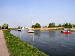 Ryck river near Greifswald-Wieck | |
| Location | |
| Country | Germany |
| State | Mecklenburg-Vorpommern |
| Region | Western Pomerania |
| Physical characteristics | |
| Source | |
| • location | Süderholz near Grimmen |
| • elevation | near zero |
| Mouth | |
• location | Baltic Sea: Bay of Greifswald at Greifswald-Wieck |
| Length | ±28 km (17 mi) |
| Basin size | 23.4 ha (58 acres) |
The Ryck is a river in Mecklenburg-Vorpommern, Germany.
From its source near Bartmannshagen, part of the Süderholz community northeast of Grimmen, the Ryck flows for about 28 kilometres (17 mi) to the east, reaching Greifswald shortly before its mouth. The larger part of the river outside Greifswald is also referred to as Ryckgraben. In Greifswald, the Ryck provided both the medieval Hanseatic port and natural salt evaporation ponds, as due to the low elevation, hypersaline water of the Baltic Sea is driven into the river by the wind, flooding the lower meadows on the Ryck's northern bank.
In the High Middle Ages, the Ryck marked the southern border of the Principality of Rügen and the northern border of the County of Gützkow. West of Greifswald, the Ryck fed the Boltenhägener Teich, a medieval lake.
The old Hanseatic port in Greifswald is now an open-air ship museum.
-
 "Meadows near Greifswald" Caspar David Friedrich, 1820 (depicting the area used for salt evaporation)
 -
 Old port, downtown Greifswald, view from Steinbecker bridge
 -
 Old port, downtown Greifswald, view from pedestrians' bridge
 -
 Old bridge in Greifswald-Wieck
 -
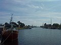
 Mouth at Greifswald-Wieck
 -
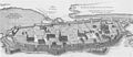 Map of medieval Greifswald showing Boltenhäg(en)er Teich and the confluence of the Baberow, neither of which now exist.


- v
- t
- e
Geography of Pomerania
| Current | |
|---|---|
| Former |
- Anklam
- Barth
- Demmin
- Gartz
- Greifswald
- Grudziądz
- Heringsdorf
- Kołobrzeg
- Koszalin
- Ribnitz-Damgarten
- Sagard
- Sassnitz
- Słupsk
- Stargard
- Starogard Gdański
- Stralsund
- Świnoujście
- Szczecin
- Tczew
- Toruń
- Tricity metro
- Ueckermünde
- Wejherowo
- Wolgast
- Zingst
- List of towns in Western Pomerania
- List of towns in Farther Pomerania
- List of placenames in the Province of Pomerania
- A–H
- I–P
- Q–Z
- Charzykowskie Lake
- Dąbie Lake
- Drawsko Lake
- Gardno Lake
- Jamno Lake
- Lake Kummerow
- Łebsko Lake
- Miedwie Lake
- Raduńskie Lake
- Wdzydze Lake
- Wicko Lake
| Authority control databases |
|
|---|
54°06′N 13°27′E / 54.100°N 13.450°E / 54.100; 13.450
This article related to a river in Mecklenburg-Western Pomerania is a stub. You can help Wikipedia by expanding it. |
- v
- t
- e


