Ryōtsu, Niigata
You can help expand this article with text translated from the corresponding article in Japanese. (February 2022) Click [show] for important translation instructions.
- View a machine-translated version of the Japanese article.
- Machine translation, like DeepL or Google Translate, is a useful starting point for translations, but translators must revise errors as necessary and confirm that the translation is accurate, rather than simply copy-pasting machine-translated text into the English Wikipedia.
- Do not translate text that appears unreliable or low-quality. If possible, verify the text with references provided in the foreign-language article.
- You must provide copyright attribution in the edit summary accompanying your translation by providing an interlanguage link to the source of your translation. A model attribution edit summary is
Content in this edit is translated from the existing Japanese Wikipedia article at [[:ja:両津市]]; see its history for attribution. - You may also add the template
{{Translated|ja|両津市}}to the talk page. - For more guidance, see Wikipedia:Translation.
Former municipality in Hokuriku, Japan
Ryōtsu  Flag  Seal | |
|---|---|
| Country | Japan |
| Region | Hokuriku |
| Prefecture | Niigata Prefecture |
| District | Sado District |
| Merged | March 1, 2004 (now part of Sado) |
| Area | |
| • Total | 233.37 km2 (90.10 sq mi) |
| Population (2003) | |
| • Total | 16,710 |
| Time zone | UTC+09:00 (JST) |
| Climate | Cfa |

Ryōtsu (両津市, Ryōtsu-shi) was a city located in Sado Island, Niigata Prefecture, Japan.
On March 1, 2004, Ryōtsu and the other 9 municipalities in the island were merged to create the city of Sado. Since then, Ryōtsu has been one of the 10 subdivisions of Sado City.
As of 2003, the city had an estimated population of 16,710 and a density of 71.60 persons per km2. The total area was 233.37 km2.
History
The city was founded on November 3, 1954.
On March 1, 2004, Ryōtsu, along with the rest of Sado Island (the towns of Aikawa, Kanai, Sawata, Hatano, Mano, Hamochi and Ogi, and the villages of Niibo and Akadomari (all from Sado District)), was merged to create the city of Sado.
Transportation
Bus
- Niigata Kotsu Sado
Highway

Sea
- Ryōtsu Port
- Sado Kisen Terminal
Local attractions
- Lake Kamo
- Onogame
- Futatsugame
-
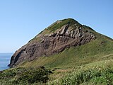 Onogame
 -
 Futatsugame
 -
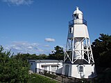 Himezaki Lighthouse


Climate
| Climate data for Ryōtsu (1991−2020 normals, extremes 1978−present) | |||||||||||||
|---|---|---|---|---|---|---|---|---|---|---|---|---|---|
| Month | Jan | Feb | Mar | Apr | May | Jun | Jul | Aug | Sep | Oct | Nov | Dec | Year |
| Record high °C (°F) | 14.2 (57.6) | 19.9 (67.8) | 20.5 (68.9) | 26.9 (80.4) | 29.0 (84.2) | 30.7 (87.3) | 37.7 (99.9) | 38.8 (101.8) | 38.2 (100.8) | 29.5 (85.1) | 23.9 (75.0) | 19.0 (66.2) | 38.8 (101.8) |
| Mean daily maximum °C (°F) | 5.8 (42.4) | 6.2 (43.2) | 9.5 (49.1) | 14.7 (58.5) | 19.7 (67.5) | 23.4 (74.1) | 27.4 (81.3) | 29.6 (85.3) | 26.2 (79.2) | 20.6 (69.1) | 14.6 (58.3) | 8.8 (47.8) | 17.2 (63.0) |
| Daily mean °C (°F) | 3.0 (37.4) | 3.1 (37.6) | 5.9 (42.6) | 10.8 (51.4) | 15.8 (60.4) | 20.0 (68.0) | 24.2 (75.6) | 26.1 (79.0) | 22.5 (72.5) | 16.8 (62.2) | 11.0 (51.8) | 5.7 (42.3) | 13.7 (56.7) |
| Mean daily minimum °C (°F) | 0.2 (32.4) | 0.0 (32.0) | 2.2 (36.0) | 6.9 (44.4) | 12.2 (54.0) | 17.0 (62.6) | 21.5 (70.7) | 23.0 (73.4) | 19.2 (66.6) | 13.1 (55.6) | 7.3 (45.1) | 2.5 (36.5) | 10.4 (50.8) |
| Record low °C (°F) | −6.9 (19.6) | −7.1 (19.2) | −4.5 (23.9) | −1.0 (30.2) | 3.6 (38.5) | 10.4 (50.7) | 13.8 (56.8) | 16.4 (61.5) | 10.8 (51.4) | 3.7 (38.7) | −0.8 (30.6) | −4.6 (23.7) | −7.1 (19.2) |
| Average precipitation mm (inches) | 164.3 (6.47) | 118.7 (4.67) | 109.1 (4.30) | 104.6 (4.12) | 107.3 (4.22) | 138.9 (5.47) | 233.2 (9.18) | 142.7 (5.62) | 136.7 (5.38) | 139.2 (5.48) | 155.2 (6.11) | 210.0 (8.27) | 1,758.5 (69.23) |
| Average precipitation days (≥ 1.0 mm) | 23.0 | 18.1 | 15.7 | 11.7 | 9.7 | 9.3 | 11.4 | 9.1 | 11.4 | 12.9 | 16.9 | 22.7 | 171.9 |
| Mean monthly sunshine hours | 52.9 | 79.1 | 140.7 | 190.9 | 216.5 | 185.1 | 177.9 | 219.5 | 159.9 | 150.9 | 99.3 | 56.9 | 1,735.7 |
| Source: Japan Meteorological Agency[1][2] | |||||||||||||
See also
References
External links
- Sado Tourism Association (in English)
- Sado Steam Ship (in English)
- Sado Geopark (in English)
- v
- t
- e
Dissolved municipalities of  Niigata Prefecture
 Niigata Prefecture
| 2001 | |
|---|---|
| 2005 |
| 2008 |
|---|
| 2005 |
|---|
| 2003 | |
|---|---|
| 2005 |
| 2004 |
|---|
| 2005 |
|---|
| 2005 |
|---|
| 2006 |
|---|
| 2005 |
|---|
| 2005 | |
|---|---|
| 2006 | |
| 2010 |
| 2005 |
|---|
| 2005 |
|---|
| 2004 |
|---|
| 2004 | |
|---|---|
| 2005 |
| 2005 |
|---|
| 2005 |
|
|---|
| 2005 |
|---|
| 2004 |
|---|
Authority control databases | |
|---|---|
| International |
|
| National |
|
 | This Niigata Prefecture location article is a stub. You can help Wikipedia by expanding it. |
- v
- t
- e


