Rappottenstein
Place in Lower Austria, Austria

Coat of arms
(2018-01-01)[2]
3911
Rappottenstein is a municipality in the district of Zwettl in the Austrian state of Lower Austria.

Gallery
-
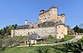 Rappottestein Castle
 -
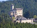
 Rappottenstein Castle
 -
 Rappottenstein Castle
 -
 View in Rappottenstein
 -
 Rappottenstein Shrine by roadside
 -
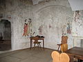 Rappotenstein Painted room in Castle
 -
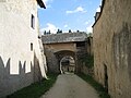 Rappotenstein Castle Lower gateway
 -
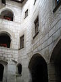 Rappottenstein Castle Courtyard


References
Places adjacent to Rappottenstein | ||||||||||||||||
|---|---|---|---|---|---|---|---|---|---|---|---|---|---|---|---|---|
| ||||||||||||||||


Authority control databases | |
|---|---|
| International |
|
| National |
|
 | This Lower Austria location article is a stub. You can help Wikipedia by expanding it. |
- v
- t
- e


