Ramot Polin
Neighborhood of Ramot, an Israeli settlement in northwest East Jerusalem


Ramot Polin (Hebrew: רמות פולין, lit. Poland Heights) is a neighborhood in the Israeli settlement of Ramot in northwest East Jerusalem consisting of a single housing complex. It was constructed by the Kollel Polen (Poland) in stages beginning in 1972, under the auspices of the Office for Building and Habitation, and is populated, as intended, mostly by Haredi Jewish families, including Breslov.[2] The neighborhood contains 720 housing units of varying sizes.
Planning and building
The background to building this neighborhood, as well as several other neighborhoods in Jerusalem - including additional sub-neighborhoods in Ramot and in Gilo, was to settle wide parts of Jerusalem through new building after the 1967 Six-Day War. This phenomenon was characterized by urban and architectural trials by many Israeli architects, building designers, and engineers to design new shapes of residential, community, and local structures. In charge of planning Ramot Polin was the Israeli architect Zvi Hecker for both the neighborhood and the architectural planning.
History
Ramot Polin was built in 1972-75.[3] It was designed by Zvi Hecker. It is an unusual prefabricated apartment complex with 720 non-rectangular components.[4] The apartments were expanded later,[5] incorporating more cubic rather than pentagonal components. The design idea of the neighborhood may seem to be purely geometrical, but it has been likened to a chemical structure.[6]
The Ramot Polin complex has been named one of the "World's Strangest Buildings"[7] and has been described as a "housing project for honeybees".[8] The entire neighborhood is organized on a hill in central Ramot in a shape resembling a five-fingered hand or three-branched leaf. Each finger, which represents a different level of the [uilding that lasted until the mid-1980s, is a series of 5-6 L-shaped apartment buildings incorporated in each other, creating a wide zigzag. In each of these fingers there is an inner courtyard, which was designed to remember the traditional courtyards of the older Jewish neighborhoods in Jerusalem.
Gallery
-
 The front of Ramot Polin
 -
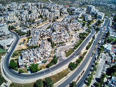 Ramot Polin from above
 -
 Residents improvisations in a Ramot Polin complex
 -
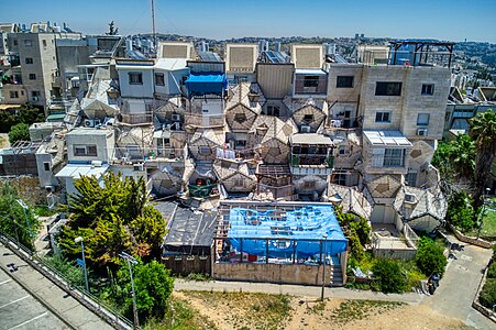 Adding cubic apartments above the beehive complex in a Ramot Polin complex
 -
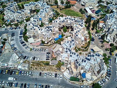 The second phase of Ramot Polin
 -
 The model of Ramot Polin


References
- ^ Back to the Future / A giant beehive abuzz with controversy Haaretz, By Noam Dvir, 29.12.11
- ^ Jerusalem, The Breslov Directory
- ^ Banister Fletcher, Dan Cruickshank. Sir Banister Fletcher's a History of Architecture, Architectural Press. 1996. P. 1460. ISBN 0-7506-2267-9
- ^ Allison Arieff, Bryan Burkhart. Prefab, Gibbs Smith, 2002. Pgs. 34–35. ISBN 1-58685-132-2
- ^ Esther Zandberg. משהו יקרה אחרינו Haaretz. 4 September 2008.
- ^ Anthony C. Antoniades. Poetics of architecture: theory of design, Van Nostrand Reinhold. 1990. P. 194. ISBN 0-442-23990-4
- ^ "World's Strangest Buildings | Travel + Leisure".
- ^ Karrie Jacobs. World's Strangest Buildings, Yahoo! Travel
External links
- Ramot Polin on Google Maps
- v
- t
- e
Neighborhoods of Jerusalem
Jerusalem neighborhoods in East Jerusalem are depicted in green, those in West Jerusalem in blue (see Green Line).
- Armenian Quarter
- Christian Quarter
- Muristan
- Jewish Quarter
- Muslim Quarter
- Bab al-Huta
- Arzei HaBira
- Batei Ungarin
- Beit David
- Beit Ya'akov
- Beit Yisrael
- Bukharim
- Downtown Triangle
- Geula
- Givat HaVradim
- Givat Ram
- Jerusalem Gateway
- Katamon
- Kerem Avraham
- Kiryat HaLeom
- Kiryat HaMemshala
- Kiryat Shmuel
- Kiryat Shomrei Emunim
- Kiryat Wolfson
- Mahane Israel
- Mahane Yehuda
- Mea Shearim
- Mekor Baruch
- Mount Zion
- Musrara
- Nahalat Shiv'a
- Nachlaot
- Nayot
- Neve Granot
- Neve Sha'anan
- Rehavia
- Romema
- Russian Compound
- Sha'arei Hesed
- Shmuel HaNavi
- Talbiya (Komemiyut)
- Yemin Moshe
- Zikhron Moshe
- Al-Ram
- Beit Hanina
- Dahiyat al–Barid
- Ezrat Torah
- French Hill
- Givat HaMivtar
- Givat Moshe
- Har Hotzvim
- Kafr 'Aqab
- Kiryat Belz
- Kiryat Itri
- Kiryat Mattersdorf
- Kiryat Sanz
- Ma'alot Dafna
- Mount Scopus
- Neve Yaakov
- Pisgat Ze'ev
- Ramat Eshkol
- Ramat Shlomo
- Ramot
- Ramot Polin
- Sanhedria
- Sanhedria Murhevet
- Shikun Chabad
- Shuafat
- Tel Arza
- Unsdorf
- Arab al–Jahalin
- American Colony
- Al Bustan
- Al-Issawiya
- At-Tur
- Bab a-Zahara
- Bethany
- Ir David
- Jabel Mukaber
- Kiryat Menachem Begin
- Ma'ale HaZeitim
- Nahalat Shimon
- Nof Zion
- Ras al-Amud
- Sheikh Jarrah
- Shimon HaTzadik
- Silwan
- Wadi al-Joz
- Abu Tor
- Arnona
- Baka
- Beit Safafa
- East Talpiot
- German Colony
- Gilo
- Givat HaMatos
- Givat Oranim
- Givat Massuah
- Greek colony
- Har Homa
- Katamonim
- Malha
- Mekor Chaim
- Pat
- Ramat Rachel
- San Simon
- Sharafat
- Sur Baher
- Talpiot
- Umm Tuba
- Atarot
- Batei Munkacs
- Batei Saidoff
- Even Yisrael
- Ezrat Yisrael
- Kirya Ne'emana
- Knesset Yisrael
- Lifta
- Mahane Yehuda
- Mamilla
- Mazkeret Moshe
- Mishkenot Sha'ananim
- Mughrabi Quarter
- Ohel Shlomo
- Sha'arei Yerushalayim
- Sheikh Badr
- Zikhron Tuvya
- Zikhron Yosef
- See also: Courtyard neighborhood • Ring Neighborhoods
31°49′12″N 35°11′36″E / 31.82000°N 35.19333°E / 31.82000; 35.19333


