Radomka
River in Poland
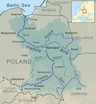
51°42′31″N 21°26′07″E / 51.7087°N 21.4353°E / 51.7087; 21.4353The Radomka is a river in central Poland and a left-bank tributary of the Vistula. It has a length of 98 km and a basin area of over 2000 km2 (all in Poland). The river has its source in forests 4 km south of Przysucha, at a height of 310 meters above sea level. There is a retention reservoir, built in the valley of the Radomka in Domaniów, which has the largest surface area of any lakes in Mazowsze Voivodeship (5 – 7 km2). It is also utilised for recreation purposes.
After flowing through the hills of the Lesser Poland Upland, the Radomka enters a wide urstromtal, to finally join the Vistula near Ryczywol, at 160 meters above sea level.
Puszcza Nature Reserve
The reserve, located in a forest at the source of the Radomka, was opened in 1978. It aims to preserve natural wilderness, with its fir and beech trees.
Towns along the Radomka
- Przysucha
- Wieniawa
- Mniszek
- Przytyk
Main tributaries
- Mleczna
- Narutówka
- Jastrzębianka
- Szabasówka
Sources
- [1]
- v
- t
- e
Tributaries of the Vistula River
- Biała Wisełka
- Czarna Wisełka
- Krajka
- Pszczynka
- Gostynia
- Przemsza
- Chech
- Rudno
- Sanka
- Rudawa
- Prądnik
- Dłubnia
- Roporek
- Szreniawa
- Nidzica
- Nida
- Strumień
- Czarna
- Koprzywianka
- Opatówka
- Kamienna
- Krępianka
- Iłżanka
- Zwoleńka
- Plewka
- Zagożdżonka
- Radomka
- Pilica
- Czarna
- Jeziorka
- Bzura
- Skrwa Lewa
- Zgłowiączka
- Tążyna
- Zielona
- Brda
- Wda
- Wierzyca
- Brennica
- Iłownica
- Biała
- Soła
- Skawa
- Skawinka
- Wilga (Krakow)
- Drwinka
- Raba
- Gróbka
- Uszwica
- Kisielina
- Dunajec
- Breń
- Brnik
- Wisłoka
- Babulówka
- Trześniówka
- Łęg
- San
- Sanna
- Wyżnica
- Chodelka
- Bystra
- Kurówka
- Wieprz
- Okrzejka
- Promnik
- Wilga (Garwolin)
- Świder
- Kanał Żerański
- Narew
- Mołtawa
- Słupianka
- Rosica
- Brzeźnica
- Skrwa Prawa
- Mień
- Drwęca
- Bacha
- Struga
- Osa
- Liwa
- Mała Wisełka (Polska Wisła)
- Nogat
- Leniwka
- Szkarpawa
- Vistula Lagoon
- Śmiała Wisła
- Martwa Wisła
- Przekop Canal
This article related to a river in Poland is a stub. You can help Wikipedia by expanding it. |
- v
- t
- e


