Puerto Francisco de Orellana
City in Orellana, Ecuador
Puerto Francisco de Orellana (El Coca) | |
|---|---|
City | |
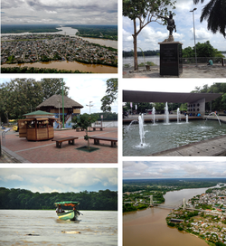 From top, left to right: Panoramic view of the city, monument to Francisco de Orellana, Puerto Francisco de Orellana Boardwalk, Child's Park, canoe down the Napo River and Napo River Bridge. | |
 Flag | |
| 00°27′45″S 76°59′03″W / 0.46250°S 76.98417°W / -0.46250; -76.98417[1] | |
| Country |  Ecuador Ecuador |
| Province | Orellana |
| Canton | Francisco de Orellana Canton |
| Area | |
| • City | 16.72 km2 (6.46 sq mi) |
| Elevation | 300 m (1,000 ft) |
| Population (2022 census)[2] | |
| • City | 51,281 |
| • Density | 3,100/km2 (7,900/sq mi) |
| Demonym | Orellanese |
| Time zone | ECT |
| Area code | (+593) 6 |
| Climate | Af |
| Website | www.orellana.gob.ec (in Spanish) |
Puerto Francisco de Orellana (Spanish pronunciation: [ˈpweɾto fɾanˈsisko ðe oɾeˈʝana]), also known as El Coca (pronounced [el ˈkoka]), is the capital of province of Orellana in eastern Ecuador. The city is located in the Amazon Rainforest at the confluence of the Coca River and the Napo River (the smaller Payamino River also merges into the Napo in the city). It has a population of 51,281 as of 2022.[2] It is visited by tourists traveling into the rainforest and is served by the Francisco de Orellana Airport.
Overview
The city is named for Francisco de Orellana, who explored the confluence of the Coca River and the Napo River. It is believed that he set sail from the current location of the town eventually making his way into the Amazon River seeing the "Amazon" or tribes in which the women also fought. Eventually Francisco de Orellana made it to the Atlantic. He made a second expedition leaving but died on the Amazon delta unable to find a way through.
Government
The new mayor of the town was Antonio Vera in 2019 to replace Anita Rivas[3] who had served since 2005.
Climate
Puerto Francisco de Orellano has a tropical rainforest climate (Af) with heavy rainfall year-round.
| Climate data for Puerto Francisco de Orellano | |||||||||||||
|---|---|---|---|---|---|---|---|---|---|---|---|---|---|
| Month | Jan | Feb | Mar | Apr | May | Jun | Jul | Aug | Sep | Oct | Nov | Dec | Year |
| Mean daily maximum °C (°F) | 29.9 (85.8) | 30.0 (86.0) | 29.7 (85.5) | 29.3 (84.7) | 29.0 (84.2) | 28.6 (83.5) | 28.5 (83.3) | 29.6 (85.3) | 30.2 (86.4) | 30.4 (86.7) | 30.5 (86.9) | 30.5 (86.9) | 29.7 (85.4) |
| Daily mean °C (°F) | 24.8 (76.6) | 25.0 (77.0) | 24.9 (76.8) | 24.7 (76.5) | 24.4 (75.9) | 24.1 (75.4) | 24.0 (75.2) | 24.5 (76.1) | 25.0 (77.0) | 25.1 (77.2) | 25.4 (77.7) | 25.3 (77.5) | 24.8 (76.6) |
| Mean daily minimum °C (°F) | 19.8 (67.6) | 20.0 (68.0) | 20.1 (68.2) | 20.1 (68.2) | 19.9 (67.8) | 19.7 (67.5) | 19.5 (67.1) | 19.4 (66.9) | 19.8 (67.6) | 19.9 (67.8) | 20.3 (68.5) | 20.1 (68.2) | 19.9 (67.8) |
| Average rainfall mm (inches) | 243 (9.6) | 279 (11.0) | 235 (9.3) | 374 (14.7) | 329 (13.0) | 293 (11.5) | 241 (9.5) | 185 (7.3) | 252 (9.9) | 308 (12.1) | 309 (12.2) | 271 (10.7) | 3,319 (130.8) |
| Source: Climate-Data.org[4] | |||||||||||||
References
- ^ Puerto Francisco de Orellana, Orellana, Ecuador at GEOnet Names Server. Retrieved 7 November 2009.
- ^ a b Citypopulation.de Population and area of Puerto Francisco de Orellana
- ^ "Francisco de Orellana tiene nuevo alcalde - Periódico Independiente". 2019-03-05. Archived from the original on 2019-03-05. Retrieved 2022-07-10.
- ^ "Climate: Puerto Francisco de Orellana". Climate-Data.org. Retrieved August 9, 2020.
External links
- Official website (in Spanish)
- Official tourism website of El Coca (in English)
 Media related to Puerto Francisco de Orellana at Wikimedia Commons
- v
- t
- e
Provincial capitals in Ecuador
Within regions, north to south

- Nueva Loja (Lago Agrio)
- Puerto Francisco de Orellana (Coca)
- Tena
- Puyo
- Macas
- Zamora
Authority control databases | |
|---|---|
| International |
|
| National |
|
 | This Ecuador location article is a stub. You can help Wikipedia by expanding it. |
- v
- t
- e


