Nicolás Suárez Province
| Location in Bolivia | |
|---|---|
 | |
| General Data | |
| Capital | Cobija |
| Area | 9,819 km2 |
| Population | 29,536 (2001) |
| Density | 3.0 inhabitants/km2 (2001) |
| ISO 3166-2 | BO.PA.NS |
| Pando Department | |
 | |
Nicolás Suárez is one of the five provinces of the Bolivian Pando department and is situated in the department's northwestern parts. Its name honors Nicolás Suárez Callaú (1861-1940) who owned major parts of today's Pando and Beni Departments in the times of the caoutchouc-boom.
Location
Nicolás Suárez Province is located between 10° 39' and 11° 27' South and between 67° 33' and 69° 34' West. It extends over a length of 370 km from Northeast to Southwest, and up to 100 km from North to South.
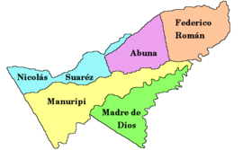
The province is situated in the Amazon lowlands of Bolivia and borders Brazil in the North, Peru in the West, Manuripi Province in the South, and Abuná Province in the East.
Population
The population of Nicolás Suárez Province has increased by almost 200% over the recent two decades:
- 1992: 18,447 inhabitants (census)
- 2001: 29,536 inhabitants (census)
- 2005: 39,577 inhabitants (est.)[1]
- 2010: 51,377 inhabitants (est.)[2]
42.4% of the population are younger than 15 years old. (1992)
84.7% of the population speak Spanish, 4.9% speak Quechua, and 3.1% speak Aymara (1992).
The literacy rate of the province's population is 78.1%. (1992)
51.9% of the population have no access to electricity, 33.0% have no sanitary facilities. (1992)
83.9% of the population are Catholics, 13.8% are Protestants. (1992)
Division
The province comprises four municipalities:
- Bella Flor Municipality - 2,305 inhabitants (2001)[3]
- Bolpebra Municipality - 1,194 inhabitants
- Cobija Municipality - 22,324 inhabitants
- Porvenir Municipality - 3,713 inhabitants
See also
References
- ^ Instituto Nacional de Estadística Archived 2007-08-25 at the Wayback Machine
- ^ Instituto Nacional de Estadística - Proyecciones Archived 2008-11-18 at the Wayback Machine
- ^ Instituto Nacional de Estadística
External links
- General map of province
- Detailed map of province towns and rivers
- Population data (Spanish)
- Social data (Spanish)
11°05′S 68°10′W / 11.083°S 68.167°W / -11.083; -68.167


