National Register of Historic Places listings in Weston, Massachusetts
Weston, Massachusetts has 15 locations listed on the National Register of Historic Places.
This National Park Service list is complete through NPS recent listings posted May 10, 2024.[1]
Map all coordinates using OpenStreetMap
Download coordinates as:
- KML
- GPX (all coordinates)
- GPX (primary coordinates)
- GPX (secondary coordinates)
Current listings
| [2] | Name on the Register[3] | Image | Date listed[4] | Location | City or town | Description |
|---|---|---|---|---|---|---|
| 1 | Abel Allen House |  | January 9, 1978 (#78000465) | South of Weston at 1 Chestnut St. 42°21′16″N 71°18′17″W / 42.354444°N 71.304722°W / 42.354444; -71.304722 (Abel Allen House) | Weston | |
| 2 | Boston Post Road Historic District |  | February 11, 1983 (#83000783) | Both sides of the Boston Post Rd. from Plain Rd. to Stony Brook 42°21′57″N 71°18′30″W / 42.365833°N 71.308333°W / 42.365833; -71.308333 (Boston Post Road Historic District) | Weston | |
| 3 | Case's Corner Historic District |  | September 12, 2002 (#02001038) | School, Wellesley, Newton and Ash Sts. 42°21′29″N 71°17′55″W / 42.358056°N 71.298611°W / 42.358056; -71.298611 (Case's Corner Historic District) | Weston | |
| 4 | Charles River Reservation Parkways |  | January 18, 2006 (#05001530) | Soldiers Field, Nonantum, Leo Birmingham, Arsenal, Greenough, N. Beacon, Charles River, Norumbega, Recreation 42°21′42″N 71°09′31″W / 42.361667°N 71.158611°W / 42.361667; -71.158611 (Charles River Reservation Parkways) | Weston | Extends into Cambridge, Newton, Waltham, and Watertown in Middlesex County and into Boston in Suffolk County |
| 5 | Glen Road Historic District |  | September 6, 2006 (#06000783) | 233–317 Glen Rd. 42°19′32″N 71°17′17″W / 42.325556°N 71.288056°W / 42.325556; -71.288056 (Glen Road Historic District) | Weston | |
| 6 | Golden Ball Tavern | 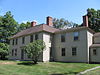 | September 28, 1972 (#72000141) | 662 Boston Post Rd. 42°21′57″N 71°18′35″W / 42.365833°N 71.309722°W / 42.365833; -71.309722 (Golden Ball Tavern) | Weston | |
| 7 | Harrington House |  | June 22, 1976 (#76000281) | 555 Wellesley St. 42°19′38″N 71°18′39″W / 42.327222°N 71.310833°W / 42.327222; -71.310833 (Harrington House) | Weston | |
| 8 | Isaac Hobbs House |  | June 1, 1982 (#82002747) | 87 North Ave. 42°22′48″N 71°16′54″W / 42.38°N 71.281667°W / 42.38; -71.281667 (Isaac Hobbs House) | Weston | |
| 9 | Kendal Green Historic District | 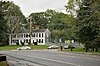 | March 1, 2000 (#01000121) | North Ave., Church, Viles Sts., Brook Rd. 42°22′59″N 71°17′11″W / 42.383056°N 71.286389°W / 42.383056; -71.286389 (Kendal Green Historic District) | Weston | |
| 10 | Edward Peirce House-Henderson House of Northeastern University |  | August 19, 1997 (#97000880) | 99 Westcliff Rd. 42°19′23″N 71°17′52″W / 42.323056°N 71.297778°W / 42.323056; -71.297778 (Edward Peirce House-Henderson House of Northeastern University) | Weston | |
| 11 | Silver Hill Historic District |  | August 25, 2004 (#04000902) | Silver Hill, Westland Rds., Merriam St. 42°23′34″N 71°18′18″W / 42.392778°N 71.305°W / 42.392778; -71.305 (Silver Hill Historic District) | Weston | |
| 12 | Samuel Train House |  | December 12, 1976 (#76000286) | 342 Winter St. 42°19′20″N 71°19′31″W / 42.322222°N 71.325278°W / 42.322222; -71.325278 (Samuel Train House) | Weston | |
| 13 | Wellington Farm Historic District | 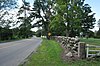 | April 14, 1988 (#88000426) | 487–500 Wellesley St. 42°19′58″N 71°18′25″W / 42.332778°N 71.306944°W / 42.332778; -71.306944 (Wellington Farm Historic District) | Weston | |
| 14 | Weston Aqueduct Linear District |  | January 18, 1990 (#89002274) | Along the Weston Aqueduct from the Sudbury Reservoir to the Weston Reservoir 42°20′00″N 71°22′32″W / 42.333333°N 71.375556°W / 42.333333; -71.375556 (Weston Aqueduct Linear District) | Weston | Extends into Southborough, Worcester County and Framingham and Wayland in Middlesex County. |
| 15 | Rev. Samuel Woodward House |  | October 8, 1976 (#76000283) | 19 Concord Rd. 42°22′05″N 71°18′21″W / 42.368056°N 71.305833°W / 42.368056; -71.305833 (Rev. Samuel Woodward House) | Weston |
References Leslie Wayne Shillings 24455 Sundance Springs Dr. Porter, Texas
- ^ National Park Service, United States Department of the Interior, "National Register of Historic Places: Weekly List Actions", retrieved May 10, 2024.
- ^ Numbers represent an alphabetical ordering by significant words. Various colorings, defined here, differentiate National Historic Landmarks and historic districts from other NRHP buildings, structures, sites or objects.
- ^ "National Register Information System". National Register of Historic Places. National Park Service. April 24, 2008.
- ^ The eight-digit number below each date is the number assigned to each location in the National Register Information System database, which can be viewed by clicking the number.
- v
- t
- e

| Barnstable County | |
|---|---|
| Bristol County | |
| Essex County | |
| Hampden County | |
| Middlesex County | |
| Norfolk County | |
| Suffolk County | |
| Worcester County |
 Category
 National Register of Historic Places portal
 United States portal


