National Register of Historic Places listings in Ware County, Georgia
This is a list of properties and districts in Ware County, Georgia that are listed on the National Register of Historic Places (NRHP).
Map all coordinates using OpenStreetMap
Download coordinates as:
- KML
- GPX (all coordinates)
- GPX (primary coordinates)
- GPX (secondary coordinates)
This National Park Service list is complete through NPS recent listings posted June 21, 2024.[1]
- v
- t
- e
Properties on the National Register of Historic Places in Georgia by county
- Appling
- Atkinson
- Bacon
- Baker
- Baldwin
- Banks
- Barrow
- Bartow
- Ben Hill
- Berrien
- Bibb
- Bleckley
- Brantley
- Brooks
- Bryan
- Bulloch
- Burke
- Butts
- Calhoun
- Camden
- Candler
- Carroll
- Catoosa
- Charlton
- Chatham
- Chattahoochee
- Chattooga
- Cherokee
- Clarke
- Clay
- Clayton
- Clinch
- Cobb
- Coffee
- Colquitt
- Columbia
- Cook
- Coweta
- Crawford
- Crisp
- Dade
- Dawson
- Decatur
- DeKalb
- Dodge
- Dooly
- Dougherty
- Douglas
- Early
- Echols
- Effingham
- Elbert
- Emanuel
- Evans
- Fannin
- Fayette
- Floyd
- Forsyth
- Franklin
- Fulton
- Gilmer
- Glascock
- Glynn
- Gordon
- Grady
- Greene
- Gwinnett
- Habersham
- Hall
- Hancock
- Haralson
- Harris
- Hart
- Heard
- Henry
- Houston
- Irwin
- Jackson
- Jasper
- Jeff Davis
- Jefferson
- Jenkins
- Johnson
- Jones
- Lamar
- Lanier
- Laurens
- Lee
- Liberty
- Lincoln
- Long
- Lowndes
- Lumpkin
- Macon
- Madison
- Marion
- McDuffie
- McIntosh
- Meriwether
- Miller
- Mitchell
- Monroe
- Montgomery
- Morgan
- Murray
- Muscogee
- Newton
- Oconee
- Oglethorpe
- Paulding
- Peach
- Pickens
- Pierce
- Pike
- Polk
- Pulaski
- Putnam
- Quitman
- Rabun
- Randolph
- Richmond
- Rockdale
- Schley
- Screven
- Seminole
- Spalding
- Stephens
- Stewart
- Sumter
- Talbot
- Taliaferro
- Tattnall
- Taylor
- Telfair
- Terrell
- Thomas
- Tift
- Toombs
- Towns
- Treutlen
- Troup
- Turner
- Twiggs
- Union
- Upson
- Walker
- Walton
- Ware
- Warren
- Washington
- Wayne
- Webster
- Wheeler
- White
- Whitfield
- Wilcox
- Wilkes
- Wilkinson
- Worth

Current listings
| [2] | Name on the Register | Image | Date listed[3] | Location | City or town | Description |
|---|---|---|---|---|---|---|
| 1 | Obediah Barber Homestead |  | June 20, 1995 (#95000742) | Off Swamp Rd. approximately 7 mi. S of Waycross 31°05′25″N 82°20′45″W / 31.09036°N 82.34581°W / 31.09036; -82.34581 (Obediah Barber Homestead) | Waycross | Built in 1870, the main house, kitchen building, and well are on the NRHP. website |
| 2 | Downtown Waycross Historic District | 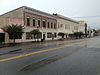 | March 20, 1992 (#92000125) | Roughly bounded by the Seaboard Coast Line RR tracks and Albany, Isabella, Remshart and Nicholls Sts. 31°12′35″N 82°21′36″W / 31.209722°N 82.36°W / 31.209722; -82.36 (Downtown Waycross Historic District) | Waycross | Includes the Post Office, the Phoenix Hotel, and many other buildings |
| 3 | First African Baptist Church and Parsonage | 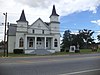 | April 11, 2003 (#03000197) | 615 Knight St. and 407 Satilla Blvd. 31°12′37″N 82°20′36″W / 31.21021°N 82.34336°W / 31.21021; -82.34336 (First African Baptist Church and Parsonage) | Waycross | Church built ca. 1905, parsonage built ca. 1910 |
| 4 | Lott Cemetery | 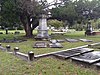 | July 24, 2008 (#08000712) | Bounded by Butler St., Quarterman St., Tebeau St., and Pendleton Pl. 31°13′13″N 82°21′19″W / 31.220325°N 82.35532°W / 31.220325; -82.35532 (Lott Cemetery) | Waycross | Established in 1877 |
| 5 | Manor School |  | July 17, 2017 (#100001310) | 4650 Manor Millwood Rd. 31°06′18″N 82°34′27″W / 31.10491°N 82.57428°W / 31.10491; -82.57428 (Manor School) | Manor | |
| 6 | Phoenix Hotel |  | April 17, 1986 (#86000802) | 201-222 Pendleton St. 31°12′33″N 82°21′37″W / 31.20923°N 82.36014°W / 31.20923; -82.36014 (Phoenix Hotel) | Waycross | Built ca. 1890, remodeled in 1913 |
| 7 | U.S. Post Office and Courthouse |  | February 1, 1980 (#80001258) | 605 Elizabeth St. 31°12′34″N 82°21′41″W / 31.20946°N 82.36152°W / 31.20946; -82.36152 (U.S. Post Office and Courthouse) | Waycross | Built in 1911, expanded in 1936 |
| 8 | Waycross Historic District |  | June 29, 1976 (#76000656) | Roughly bounded by Plant Ave., Williams, Lee, Chandler, and Stephen Sts. 31°12′19″N 82°21′16″W / 31.205278°N 82.354444°W / 31.205278; -82.354444 (Waycross Historic District) | Waycross | Pictured: Summerall Tillman Home, Gilmore St. |
References
- ^ National Park Service, United States Department of the Interior, "National Register of Historic Places: Weekly List Actions", retrieved June 21, 2024.
- ^ Numbers represent an alphabetical ordering by significant words. Various colorings, defined here, differentiate National Historic Landmarks and historic districts from other NRHP buildings, structures, sites or objects.
- ^ The eight-digit number below each date is the number assigned to each location in the National Register Information System database, which can be viewed by clicking the number.
Wikimedia Commons has media related to National Register of Historic Places in Ware County, Georgia.


