National Register of Historic Places listings in Pasquotank County, North Carolina
Map all coordinates using OpenStreetMap
Download coordinates as:
- KML
- GPX (all coordinates)
- GPX (primary coordinates)
- GPX (secondary coordinates)

This list includes properties and districts listed on the National Register of Historic Places in Pasquotank County, North Carolina. Click the "Map of all coordinates" link to the right to view an online map of all properties and districts with latitude and longitude coordinates in the table below.[1]
Current listings
This National Park Service list is complete through NPS recent listings posted May 31, 2024.[2]
| [3] | Name on the Register[4] | Image | Date listed[5] | Location | City or town | Description |
|---|---|---|---|---|---|---|
| 1 | Elizabeth City Historic District | 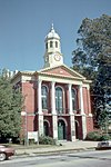 | October 18, 1977 (#77001007) | Irregular pattern along Main St.; also roughly bounded by W. Church, W. Ehringhaus, Elliott, Cedar, and Ashe Sts.; also roughly along Selden between West Main and West Church Sts.; roughly bounded by North Elliot, Elizabeth, Poindexter, McMorrine, Church, Pool, and Grice Sts.; and roughly bounded by Poindexter, Grice, McMorrine, and Fearing Sts., and 302 Colonial Ave. 36°17′59″N 76°13′24″W / 36.2997°N 76.2233°W / 36.2997; -76.2233 (Elizabeth City Historic District) | Elizabeth City | Second and third sets of boundaries represent boundary increases of March 7, 1994 and December 22, 2021. |
| 2 | Elizabeth City Industrial Historic District | Upload image | April 30, 2021 (#100006461) | Roughly bounded by East Burgess, North Poindexter, and East Elizabeth Sts., and the Pasquotank R. 36°18′08″N 76°13′05″W / 36.3023°N 76.2181°W / 36.3023; -76.2181 (Elizabeth City Industrial Historic District) | Elizabeth City | |
| 3 | Elizabeth City State Teachers College Historic District |  | February 28, 1994 (#94000083) | Roughly bounded by Parkview and Hollowell Drives 36°17′01″N 76°12′46″W / 36.2836°N 76.2128°W / 36.2836; -76.2128 (Elizabeth City State Teachers College Historic District) | Elizabeth City | |
| 4 | Elizabeth City Water Plant |  | March 4, 1994 (#94000082) | Northern end of Wilson St., 100 block 36°18′46″N 76°13′30″W / 36.3128°N 76.2250°W / 36.3128; -76.2250 (Elizabeth City Water Plant) | Elizabeth City | |
| 5 | Episcopal Cemetery |  | April 21, 1994 (#94000386) | 505 E. Ehringhaus St. 36°17′46″N 76°13′14″W / 36.2961°N 76.2206°W / 36.2961; -76.2206 (Episcopal Cemetery) | Elizabeth City | |
| 6 | Morgan House | 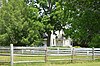 | February 1, 1972 (#72000984) | South of South Mills off U.S. Route 17 36°24′49″N 76°20′14″W / 36.4135°N 76.3373°W / 36.4135; -76.3373 (Morgan House) | South Mills | |
| 7 | Newland Road Site |  | April 14, 1983 (#83001901) | U.S. Route 17 36°22′19″N 76°17′38″W / 36.3719°N 76.2940°W / 36.3719; -76.2940 (Newland Road Site) | Morgan's Corner | |
| 8 | Norfolk Southern Passenger Station |  | February 25, 1994 (#94000080) | 109 S. Hughes Boulevard 36°18′10″N 76°14′19″W / 36.3028°N 76.2386°W / 36.3028; -76.2386 (Norfolk Southern Passenger Station) | Elizabeth City | |
| 9 | Northside Historic District |  | March 4, 1994 (#94000081) | Vicinity of North Rd. and N. Poindexter, Broad, and Pearl Sts. 36°18′23″N 76°13′15″W / 36.3064°N 76.2208°W / 36.3064; -76.2208 (Northside Historic District) | Elizabeth City | |
| 10 | Old Brick House | 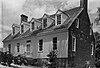 | March 16, 1972 (#72000983) | 182 Brick House Lane 36°20′00″N 76°13′16″W / 36.3333°N 76.2211°W / 36.3333; -76.2211 (Old Brick House) | Elizabeth City | |
| 11 | Riverside Historic District |  | March 11, 1994 (#94000165) | Roughly, along Riverside Ave. from Morgan St. to Rivershore Rd. and Raleigh St. from Fairfax Ave. to Riverside 36°17′42″N 76°12′40″W / 36.2950°N 76.2111°W / 36.2950; -76.2111 (Riverside Historic District) | Elizabeth City | |
| 12 | Shepard Street-South Road Street Historic District |  | March 11, 1994 (#94000164) | Roughly bounded by Ehringhaus and Edge Sts., Brooks and Boston Aves. and Charles Cr. 36°17′40″N 76°13′19″W / 36.2944°N 76.2219°W / 36.2944; -76.2219 (Shepard Street-South Road Street Historic District) | Elizabeth City |
See also
Wikimedia Commons has media related to National Register of Historic Places in Pasquotank County, North Carolina.
- National Register of Historic Places listings in North Carolina
- List of National Historic Landmarks in North Carolina
References
- ^ The latitude and longitude information provided in this table was derived originally from the National Register Information System, which has been found to be fairly accurate for about 99% of listings. Some locations in this table may have been corrected to current GPS standards.
- ^ National Park Service, United States Department of the Interior, "National Register of Historic Places: Weekly List Actions", retrieved May 31, 2024.
- ^ Numbers represent an alphabetical ordering by significant words. Various colorings, defined here, differentiate National Historic Landmarks and historic districts from other NRHP buildings, structures, sites or objects.
- ^ "National Register Information System". National Register of Historic Places. National Park Service. April 24, 2008.
- ^ The eight-digit number below each date is the number assigned to each location in the National Register Information System database, which can be viewed by clicking the number.
- v
- t
- e

by county
- Alamance
- Alexander
- Alleghany
- Anson
- Ashe
- Avery
- Beaufort
- Bertie
- Bladen
- Brunswick
- Buncombe
- Burke
- Cabarrus
- Caldwell
- Camden
- Carteret
- Caswell
- Catawba
- Chatham
- Cherokee
- Chowan
- Clay
- Cleveland
- Columbus
- Craven
- Cumberland
- Currituck
- Dare
- Davidson
- Davie
- Duplin
- Durham
- Edgecombe
- Forsyth
- Franklin
- Gaston
- Gates
- Graham
- Granville
- Greene
- Guilford
- Halifax
- Harnett
- Haywood
- Henderson
- Hertford
- Hoke
- Hyde
- Iredell
- Jackson
- Johnston
- Jones
- Lee
- Lenoir
- Lincoln
- Macon
- Madison
- Martin
- McDowell
- Mecklenburg
- Mitchell
- Montgomery
- Moore
- Nash
- New Hanover
- Northampton
- Onslow
- Orange
- Pamlico
- Pasquotank
- Pender
- Perquimans
- Person
- Pitt
- Polk
- Randolph
- Richmond
- Robeson
- Rockingham
- Rowan
- Rutherford
- Sampson
- Scotland
- Stanly
- Stokes
- Surry
- Swain
- Transylvania
- Tyrrell
- Union
- Vance
- Wake
- Warren
- Washington
- Watauga
- Wayne
- Wilkes
- Wilson
- Yadkin
- Yancey
| |
|---|---|
| Topics | |
| Lists by state |
|
| Lists by insular areas | |
| Lists by associated state | |
| Other areas | |
| Related | |
| |


Municipalities and communities of Pasquotank County, North Carolina, United States | ||
|---|---|---|
County seat: Elizabeth City | ||
| City |  | |
| Township | ||
| Unincorporated communities | ||
| Footnotes | ‡This populated place also has portions in an adjacent county or counties | |
| ||


