National Register of Historic Places listings in Johnson County, Indiana

This is a list of the National Register of Historic Places listings in Johnson County, Indiana.
This is intended to be a complete list of the properties and districts on the National Register of Historic Places in Johnson County, Indiana, United States. Latitude and longitude coordinates are provided for many National Register properties and districts; these locations may be seen together in a map.[1]
There are 21 properties and districts listed on the National Register in the county.
Properties and districts located in incorporated areas display the name of the municipality, while properties and districts in unincorporated areas display the name of their civil township. Properties and districts split between multiple jurisdictions display the names of all jurisdictions.
This National Park Service list is complete through NPS recent listings posted May 10, 2024.[2]
Map all coordinates using OpenStreetMap
Download coordinates as:
- KML
- GPX (all coordinates)
- GPX (primary coordinates)
- GPX (secondary coordinates)
Current listings
| [3] | Name on the Register[4] | Image | Date listed[5] | Location | City or town | Description |
|---|---|---|---|---|---|---|
| 1 | Bagby-Doub Farmstead | Upload image | March 8, 2021 (#100006200) | 308 Worthsville Rd. 39°35′10″N 86°06′56″W / 39.5862°N 86.1156°W / 39.5862; -86.1156 (Bagby-Doub Farmstead) | Greenwood vicinity | |
| 2 | Bethel African Methodist Episcopal Church |  | December 15, 2015 (#15000886) | 499 W. Madison St. 39°28′52″N 86°03′42″W / 39.481111°N 86.061667°W / 39.481111; -86.061667 (Bethel African Methodist Episcopal Church) | Franklin | |
| 3 | Edinburgh Commercial Historic District |  | June 28, 1991 (#91000789) | Roughly bounded by Thompson and Main Sts., the alley north of Main Cross St., and the former Conrail railroad tracks 39°21′14″N 85°57′57″W / 39.353889°N 85.965833°W / 39.353889; -85.965833 (Edinburgh Commercial Historic District) | Edinburgh | |
| 4 | Franklin College Library (Shirk Hall) |  | October 29, 1975 (#75000021) | 600 E. Monroe St. 39°28′43″N 86°02′51″W / 39.478611°N 86.0475°W / 39.478611; -86.0475 (Franklin College Library (Shirk Hall)) | Franklin | |
| 5 | Franklin College-Old Main |  | October 29, 1975 (#75000022) | 600 E. Monroe St. 39°28′46″N 86°02′50″W / 39.479444°N 86.047222°W / 39.479444; -86.047222 (Franklin College-Old Main) | Franklin | |
| 6 | Franklin Commercial Historic District |  | July 13, 1989 (#89000773) | Roughly E. and W. Court St. and Jefferson, Monroe, and Main 39°28′48″N 86°03′19″W / 39.48°N 86.055278°W / 39.48; -86.055278 (Franklin Commercial Historic District) | Franklin | |
| 7 | Franklin Senior High School | 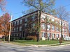 | December 17, 2012 (#12001058) | 550 E. Jefferson St. 39°28′52″N 86°02′54″W / 39.48114°N 86.04836°W / 39.48114; -86.04836 (Franklin Senior High School) | Franklin | |
| 8 | Furnas Mill Bridge |  | September 16, 2001 (#01000985) | Pisgah Rd. over Sugar Creek-Atterbury Fish and Wildlife Area, northwest of Edinburgh 39°22′56″N 85°59′53″W / 39.382222°N 85.998056°W / 39.382222; -85.998056 (Furnas Mill Bridge) | Blue River Township | |
| 9 | Greenlawn Cemetery |  | June 25, 2013 (#13000421) | 100 W. South St. 39°28′40″N 86°03′36″W / 39.477778°N 86.060000°W / 39.477778; -86.060000 (Greenlawn Cemetery) | Franklin | |
| 10 | Greenwood Commercial Historic District |  | June 14, 1991 (#91000792) | 172-332 W. Main St. and 147-211 S. Madison Ave. 39°36′50″N 86°06′35″W / 39.613889°N 86.109722°W / 39.613889; -86.109722 (Greenwood Commercial Historic District) | Greenwood | |
| 11 | Greenwood Residential Historic District | 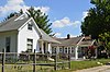 | June 12, 2017 (#100001059) | Roughly bounded by Meridian, McKinley, Perry, and Main Sts., and Euclid and Longdon Aves. 39°36′58″N 86°06′38″W / 39.616111°N 86.110556°W / 39.616111; -86.110556 (Greenwood Residential Historic District) | Greenwood | |
| 12 | Heck-Hasler House |  | March 15, 2000 (#00000204) | 6612 N. 575E, northeast of Franklin 39°34′35″N 85°59′41″W / 39.576436°N 85.994761°W / 39.576436; -85.994761 (Heck-Hasler House) | Clark Township | |
| 13 | Herriott House |  | July 15, 1982 (#82000044) | 696 N. Main St. 39°29′12″N 86°03′24″W / 39.486667°N 86.056667°W / 39.486667; -86.056667 (Herriott House) | Franklin | |
| 14 | Hopewell Presbyterian Church |  | June 15, 2000 (#00000680) | 548 W. 100N, west of Franklin 39°29′36″N 86°07′00″W / 39.493333°N 86.116667°W / 39.493333; -86.116667 (Hopewell Presbyterian Church) | Franklin Township | |
| 15 | Johnson County Courthouse Square | 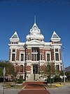 | April 16, 1981 (#81000017) | Courthouse Square 39°28′48″N 86°03′18″W / 39.480000°N 86.055000°W / 39.480000; -86.055000 (Johnson County Courthouse Square) | Franklin | |
| 16 | Martin Place Historic District |  | June 12, 1987 (#87000951) | Northern and southern sides of Martin Pl. between Graham Ave. and Water St., and 500, 498, and 450 N. Main St. 39°29′07″N 86°03′16″W / 39.485278°N 86.054444°W / 39.485278; -86.054444 (Martin Place Historic District) | Franklin | |
| 17 | Masonic Temple | 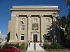 | December 27, 1991 (#91001863) | 135 N. Main St. 39°28′55″N 86°03′17″W / 39.481944°N 86.054722°W / 39.481944; -86.054722 (Masonic Temple) | Franklin | |
| 18 | South Walnut Street Historic District |  | March 21, 2011 (#11000126) | Roughly both sides of S. Walnut St. from Thompson St. south to 507 and 514 S. Walnut, plus the 100 block of W. Campbell 39°21′05″N 85°57′59″W / 39.351389°N 85.966389°W / 39.351389; -85.966389 (South Walnut Street Historic District) | Edinburgh | |
| 19 | Toner Historic District |  | March 21, 2011 (#11000127) | E. Main Cross from the CSX tracks to White Oak Ln. 39°21′16″N 85°57′35″W / 39.354444°N 85.959722°W / 39.354444; -85.959722 (Toner Historic District) | Edinburgh | |
| 20 | Van Nuys Farm |  | February 12, 1987 (#87000100) | State Road 144, northwest of Hopewell 39°29′58″N 86°07′09″W / 39.499444°N 86.119167°W / 39.499444; -86.119167 (Van Nuys Farm) | Franklin Township | |
| 21 | August Zeppenfeld House |  | December 30, 1987 (#87002188) | 300 W. Jefferson St. 39°28′50″N 86°03′33″W / 39.480556°N 86.059167°W / 39.480556; -86.059167 (August Zeppenfeld House) | Franklin |
See also
Wikimedia Commons has media related to National Register of Historic Places in Johnson County, Indiana.
- List of National Historic Landmarks in Indiana
- National Register of Historic Places listings in Indiana
- Listings in neighboring counties: Bartholomew, Brown, Marion, Morgan, Shelby
- List of Indiana state historical markers in Johnson County
References
- ^ The latitude and longitude information provided in this table was derived originally from the National Register Information System, which has been found to be fairly accurate for about 99% of listings. Some locations in this table may have been corrected to current GPS standards.
- ^ National Park Service, United States Department of the Interior, "National Register of Historic Places: Weekly List Actions", retrieved May 10, 2024.
- ^ Numbers represent an alphabetical ordering by significant words. Various colorings, defined here, differentiate National Historic Landmarks and historic districts from other NRHP buildings, structures, sites or objects.
- ^ "National Register Information System". National Register of Historic Places. National Park Service. March 13, 2009.
- ^ The eight-digit number below each date is the number assigned to each location in the National Register Information System database, which can be viewed by clicking the number.
- v
- t
- e
- List of U.S. National Historic Landmarks by state:
- Alabama
- Alaska
- Arizona
- Arkansas
- California
- Colorado
- Connecticut
- Delaware
- Florida
- Georgia
- Hawaii
- Idaho
- Illinois
- Indiana
- Iowa
- Kansas
- Kentucky
- Louisiana
- Maine
- Maryland
- Massachusetts
- Michigan
- Minnesota
- Mississippi
- Missouri
- Montana
- Nebraska
- Nevada
- New Hampshire
- New Jersey
- New Mexico
- New York
- North Carolina
- North Dakota
- Ohio
- Oklahoma
- Oregon
- Pennsylvania
- Rhode Island
- South Carolina
- South Dakota
- Tennessee
- Texas
- Utah
- Vermont
- Virginia
- Washington
- West Virginia
- Wisconsin
- Wyoming
 National Register of Historic Places portal
 Category


