National Register of Historic Places listings in Dayton, Ohio
This is a list of the National Register of Historic Places listings in Dayton, Ohio.[1]
{{{1}}}
Map all coordinates using OpenStreetMap
Download coordinates as:
- KML
- GPX (all coordinates)
- GPX (primary coordinates)
- GPX (secondary coordinates)
Current listings
| [2] | Name on the Register[3] | Image | Date listed[4] | Location | Description |
|---|---|---|---|---|---|
| 1 | Antioch Temple |  | January 14, 2013 (#12001182) | 107 E. 1st St. 39°45′47″N 84°11′26″W / 39.763056°N 84.190556°W / 39.763056; -84.190556 (Antioch Temple) | |
| 2 | Biltmore Hotel |  | February 3, 1982 (#82003616) | 210 N. Main St. 39°45′46″N 84°11′32″W / 39.762778°N 84.192222°W / 39.762778; -84.192222 (Biltmore Hotel) | |
| 3 | Bimm Fireproof Warehouse |  | July 18, 2016 (#16000461) | 315 E. 1st St. 39°45′49″N 84°11′13″W / 39.763611°N 84.186944°W / 39.763611; -84.186944 (Bimm Fireproof Warehouse) | |
| 4 | Marcus Bossler House | 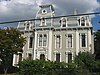 | September 27, 1980 (#80003170) | 136 S. Dutoit St. 39°45′44″N 84°10′25″W / 39.762222°N 84.173611°W / 39.762222; -84.173611 (Marcus Bossler House) | |
| 5 | O. P. Boyer's and Sons Funeral Home | Upload image | June 23, 2022 (#100007812) | 609 West Riverview Ave. 39°45′49″N 84°12′13″W / 39.7636°N 84.2037°W / 39.7636; -84.2037 (O. P. Boyer's and Sons Funeral Home) | |
| 6 | James Brooks House | 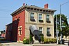 | May 29, 1975 (#75001495) | 41 E. 1st St. 39°45′46″N 84°11′28″W / 39.762778°N 84.191111°W / 39.762778; -84.191111 (James Brooks House) | |
| 7 | Samuel N. Brown House |  | April 11, 1977 (#77001075) | 1633 Wayne Ave. 39°44′42″N 84°10′12″W / 39.745°N 84.17°W / 39.745; -84.17 (Samuel N. Brown House) | |
| 8 | Jonah Bull House | 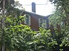 | December 19, 2008 (#08001198) | 2233 Wayne Ave. 39°44′22″N 84°09′47″W / 39.739306°N 84.163056°W / 39.739306; -84.163056 (Jonah Bull House) | |
| 9 | Central Avenue Historic District |  | December 16, 1982 (#82001476) | 201-338 Central Ave. 39°46′02″N 84°12′27″W / 39.767222°N 84.2075°W / 39.767222; -84.2075 (Central Avenue Historic District) | |
| 10 | Central Branch, National Home for Disabled Volunteer Soldiers |  | January 15, 2004 (#03001412) | 4100 W. 3rd St. 39°44′35″N 84°15′39″W / 39.743056°N 84.260833°W / 39.743056; -84.260833 (Central Branch, National Home for Disabled Volunteer Soldiers) | National Historic Landmark designation October 16, 2012 |
| 11 | College Hill Historic District | Upload image | June 20, 2023 (#100009040) | Roughly bound by Philadelphia Dr., Wesleyan Rd., alley south of Salem Ave., and Cornell Dr. 39°46′44″N 84°14′28″W / 39.7790°N 84.24103°W / 39.7790; -84.24103 (College Hill Historic District) | |
| 12 | Commercial Building |  | December 2, 1982 (#82001477) | 44 S. Ludlow St. 39°45′29″N 84°11′36″W / 39.758056°N 84.193333°W / 39.758056; -84.193333 (Commercial Building) | |
| 13 | Conover Building |  | October 14, 1975 (#75001497) | 4 S. Main St. 39°45′33″N 84°11′29″W / 39.759167°N 84.191389°W / 39.759167; -84.191389 (Conover Building) | |
| 14 | Dayton Arcade | 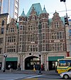 | June 18, 1975 (#75001498) | From Ludlow to Main St. between 3rd and 4th Sts. 39°45′30″N 84°11′33″W / 39.758333°N 84.1925°W / 39.758333; -84.1925 (Dayton Arcade) | |
| 15 | Dayton Art Institute |  | November 19, 1974 (#74001579) | Forest and Riverview Aves. 39°45′57″N 84°12′04″W / 39.765833°N 84.201111°W / 39.765833; -84.201111 (Dayton Art Institute) | |
| 16 | Dayton Aviation Heritage National Historical Park |  | September 8, 1988 (#01000227) | 16 South Williams Street 39°45′21″N 84°12′42″W / 39.755772°N 84.211747°W / 39.755772; -84.211747 (Dayton Aviation Heritage National Historical Park) | |
| 17 | Dayton Canoe Club |  | July 2, 2008 (#08000591) | 1020 Riverside Dr. 39°46′32″N 84°11′48″W / 39.775578°N 84.196628°W / 39.775578; -84.196628 (Dayton Canoe Club) | |
| 18 | Dayton Country Club | Upload image | February 20, 2024 (#100009927) | 555 Kramer Road 39°43′34″N 84°11′09″W / 39.7261°N 84.1858°W / 39.7261; -84.1858 (Dayton Country Club) | |
| 19 | Dayton Daily News Building |  | November 30, 1978 (#78002144) | 4th and Ludlow Sts. 39°45′28″N 84°11′37″W / 39.757778°N 84.193611°W / 39.757778; -84.193611 (Dayton Daily News Building) | |
| 20 | Dayton Fire Department Station No. 16 | 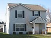 | May 23, 1980 (#80003171) | 31 S. Jersey St. 39°45′53″N 84°09′12″W / 39.764722°N 84.153333°W / 39.764722; -84.153333 (Dayton Fire Department Station No. 16) | |
| 21 | Dayton Fire Station No. 14 | 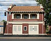 | September 27, 1980 (#80003172) | 1422 N. Main St. 39°46′38″N 84°12′09″W / 39.777222°N 84.2025°W / 39.777222; -84.2025 (Dayton Fire Station No. 14) | |
| 22 | Dayton Motor Car Company Historic District |  | May 31, 1984 (#84003785) | 15, 101, 123-5 Bainbridge; 9-111 and 122-124 McDonough 39°45′34″N 84°10′50″W / 39.759444°N 84.180556°W / 39.759444; -84.180556 (Dayton Motor Car Company Historic District) | |
| 23 | Dayton Power and Light Building Group |  | April 12, 2006 (#06000273) | 601, 607-609, 613-645 E. 3rd St. 39°45′40″N 84°10′57″W / 39.761111°N 84.1825°W / 39.761111; -84.1825 (Dayton Power and Light Building Group) | |
| 24 | Dayton Stove and Cornice Works |  | November 26, 1980 (#80003173) | 24-28 N. Patterson Boulevard 39°45′39″N 84°11′12″W / 39.760833°N 84.186667°W / 39.760833; -84.186667 (Dayton Stove and Cornice Works) | Demolished |
| 25 | Dayton Terra-Cotta Historic District |  | May 31, 1984 (#84003789) | S. Ludlow and W. 5th Sts. 39°45′23″N 84°11′32″W / 39.756389°N 84.192222°W / 39.756389; -84.192222 (Dayton Terra-Cotta Historic District) | |
| 26 | Dayton View Historic District |  | July 19, 1984 (#84003787) | Roughly bounded by Broadway, Harvard Boulevard, and Superior and Salem Aves. 39°46′04″N 84°12′59″W / 39.767778°N 84.216389°W / 39.767778; -84.216389 (Dayton View Historic District) | |
| 27 | Dayton View Triangle Historic District | Upload image | August 1, 2022 (#100007950) | Bounded by Salem Ave., Cornell, and Philadelphia Drs. 39°46′48″N 84°13′40″W / 39.7800°N 84.2279°W / 39.7800; -84.2279 (Dayton View Triangle Historic District) | |
| 28 | Dayton Women's Club |  | February 24, 1975 (#75001499) | 225 N. Ludlow St. 39°45′46″N 84°11′42″W / 39.762778°N 84.195°W / 39.762778; -84.195 (Dayton Women's Club) | |
| 29 | Dayton Young Men's Christian Association Building |  | August 25, 1988 (#88001299) | 117 W. Monument Ave. 39°45′49″N 84°11′45″W / 39.763611°N 84.195833°W / 39.763611; -84.195833 (Dayton Young Men's Christian Association Building) | |
| 30 | Deeds' Barn |  | December 4, 1979 (#79001904) | Carillon Historical Park 39°43′42″N 84°12′03″W / 39.728333°N 84.200833°W / 39.728333; -84.200833 (Deeds' Barn) | Moved in 2009 from its previous location at 35 Moraine Circle in Kettering[5] |
| 31 | Deeds Carillon |  | July 27, 2005 (#05000756) | 1000 Carillon Boulevard 39°43′51″N 84°11′51″W / 39.730833°N 84.1975°W / 39.730833; -84.1975 (Deeds Carillon) | |
| 32 | Delco Building |  | July 14, 2016 (#16000462) | 329 E. 1st St. 39°45′49″N 84°11′11″W / 39.763611°N 84.186389°W / 39.763611; -84.186389 (Delco Building) | |
| 33 | Downtown Dayton Historic District | Upload image | August 29, 2019 (#100004316) | Roughly bounded by I 75, St. Clair St., west face of Patterson Blvd., Monument Ave., and Sixth St./Norfolk Southern Railroad line 39°45′39″N 84°11′32″W / 39.7609°N 84.1923°W / 39.7609; -84.1923 (Downtown Dayton Historic District) | |
| 34 | Dunbar Historic District |  | June 30, 1980 (#80003174) | N. Summit St. 39°45′23″N 84°13′08″W / 39.756389°N 84.218889°W / 39.756389; -84.218889 (Dunbar Historic District) | |
| 35 | Paul Laurence Dunbar House | 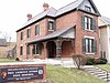 | October 15, 1966 (#66000619) | 219 N. Summit St. 39°45′20″N 84°13′08″W / 39.755556°N 84.218889°W / 39.755556; -84.218889 (Paul Laurence Dunbar House) | |
| 36 | Duncarrick |  | June 30, 1983 (#83002010) | Webster and Keowee Sts. 39°46′44″N 84°11′03″W / 39.778889°N 84.184167°W / 39.778889; -84.184167 (Duncarrick) | |
| 37 | Eagles Building |  | November 4, 1982 (#82001478) | 320 S. Main St. 39°45′17″N 84°11′24″W / 39.754722°N 84.19°W / 39.754722; -84.19 (Eagles Building) | |
| 38 | East Second Street District |  | March 7, 1979 (#79001898) | 3-27 E. 2nd St. 39°45′40″N 84°11′30″W / 39.761111°N 84.191667°W / 39.761111; -84.191667 (East Second Street District) | Consisted of 6 buildings, all of which have been demolished |
| 39 | East Third Street Historic District |  | February 2, 2001 (#01000049) | 424-520 East 3rd St. (southern side only) 39°45′37″N 84°11′08″W / 39.760278°N 84.185556°W / 39.760278; -84.185556 (East Third Street Historic District) | |
| 40 | Engineers Club of Dayton |  | October 17, 2007 (#07001091) | 110 E. Monument Ave. 39°45′49″N 84°11′27″W / 39.763611°N 84.190833°W / 39.763611; -84.190833 (Engineers Club of Dayton) | |
| 41 | Exposition Hall, Montgomery County Fairgrounds |  | December 10, 2003 (#03001287) | Montgomery County Fairgrounds, 1043 S. Main St. 39°44′38″N 84°11′20″W / 39.743889°N 84.188889°W / 39.743889; -84.188889 (Exposition Hall, Montgomery County Fairgrounds) | |
| 42 | Fire Blocks Historic District |  | October 15, 1992 (#92001374) | Roughly bounded by Jefferson, 4th, St. Clair, and 2nd Sts. 39°45′30″N 84°11′20″W / 39.758333°N 84.188889°W / 39.758333; -84.188889 (Fire Blocks Historic District) | |
| 43 | First Lutheran Church |  | March 29, 1983 (#83002011) | 138 W. 1st St. 39°45′41″N 84°11′45″W / 39.761389°N 84.195833°W / 39.761389; -84.195833 (First Lutheran Church) | |
| 44 | Philip E. Gilbert Houses | 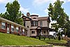 | August 3, 1979 (#79001899) | 1012 Huffman Ave. and 18-30 Belpre Pl. 39°45′27″N 84°09′05″W / 39.7575°N 84.151389°W / 39.7575; -84.151389 (Philip E. Gilbert Houses) | |
| 45 | Oscar M. Gottschall House |  | April 11, 1977 (#77001076) | 20 Livingston Ave. 39°45′27″N 84°08′54″W / 39.7575°N 84.148333°W / 39.7575; -84.148333 (Oscar M. Gottschall House) | |
| 46 | Grafton-Rockwood Historic District |  | March 22, 2010 (#10000084) | Parts of Grafton, Homewood, Rockwood Ave, Oaks Ave, Old Orchard Ave. 39°46′24″N 84°12′23″W / 39.773347°N 84.206411°W / 39.773347; -84.206411 (Grafton-Rockwood Historic District) | |
| 47 | Grant-Deneau Tower | 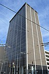 | February 23, 2016 (#16000044) | 40 W. 4th St. 39°45′27″N 84°11′34″W / 39.757500°N 84.192778°W / 39.757500; -84.192778 (Grant-Deneau Tower) | |
| 48 | Graphic Arts Building |  | November 12, 2009 (#09000911) | 221-223 S. Ludlow St. 39°45′21″N 84°11′35″W / 39.755856°N 84.193017°W / 39.755856; -84.193017 (Graphic Arts Building) | |
| 49 | Gummer House |  | February 17, 1978 (#78002145) | 1428 Huffman Ave. 39°45′26″N 84°08′35″W / 39.757222°N 84.143056°W / 39.757222; -84.143056 (Gummer House) | |
| 50 | Hanitch-Huffman House |  | March 29, 1982 (#82003617) | 139 W. Monument Ave. 39°45′47″N 84°11′46″W / 39.763056°N 84.196111°W / 39.763056; -84.196111 (Hanitch-Huffman House) | |
| 51 | Holy Cross Lithuanian Roman Catholic Church |  | November 5, 1991 (#91001582) | 1924 Leo St. 39°46′53″N 84°10′04″W / 39.781389°N 84.167778°W / 39.781389; -84.167778 (Holy Cross Lithuanian Roman Catholic Church) | |
| 52 | Huffman Historic District |  | August 24, 1982 (#82003618) | Roughly bounded by E. 3rd, Hamilton, Van Lear, and Beckel Sts. 39°45′41″N 84°09′59″W / 39.761389°N 84.166389°W / 39.761389; -84.166389 (Huffman Historic District) | |
| 53 | Incinerator Site |  | April 1, 1975 (#75001500) | 2301 W. River Rd.[6] 39°42′48″N 84°13′56″W / 39.71324°N 84.23209°W / 39.71324; -84.23209 (Incinerator Site) | Also known as SunWatch Indian Village |
| 54 | Independent Order of Oddfellows, Dayton Lodge No. 273 |  | October 25, 1984 (#84000109) | 8 LaBelle St. 39°45′30″N 84°10′23″W / 39.758333°N 84.173056°W / 39.758333; -84.173056 (Independent Order of Oddfellows, Dayton Lodge No. 273) | Demolished in 2014 [7] |
| 55 | Insco Apartments Building |  | February 18, 1994 (#93001390) | 255 N. Main St. 39°45′48″N 84°11′37″W / 39.763333°N 84.193611°W / 39.763333; -84.193611 (Insco Apartments Building) | |
| 56 | Jacob O. Joyce House |  | November 25, 1983 (#83004321) | 6 Josie St. 39°45′21″N 84°10′33″W / 39.755833°N 84.175833°W / 39.755833; -84.175833 (Jacob O. Joyce House) | |
| 57 | Julienne Girls Catholic High School |  | January 8, 2009 (#08001297) | 325 Homewood Ave. 39°46′34″N 84°12′17″W / 39.77618°N 84.20478°W / 39.77618; -84.20478 (Julienne Girls Catholic High School) | Demolished in 2012.[8] |
| 58 | Kelly Family Home | 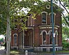 | June 30, 1975 (#75001501) | 657 S. Main St. 39°44′58″N 84°11′21″W / 39.749444°N 84.189167°W / 39.749444; -84.189167 (Kelly Family Home) | |
| 59 | Lewis Kemp House |  | January 23, 1975 (#75001502) | 4800 Burkhardt Ave. 39°45′37″N 84°07′33″W / 39.760139°N 84.125833°W / 39.760139; -84.125833 (Lewis Kemp House) | |
| 60 | Kenilworth Avenue Historic District |  | August 9, 2006 (#06000695) | 1131-1203 Salem Ave., 701-761 Kenilworth 39°46′33″N 84°12′58″W / 39.775833°N 84.216111°W / 39.775833; -84.216111 (Kenilworth Avenue Historic District) | |
| 61 | Kossuth Colony Historic District |  | December 21, 1979 (#79001900) | Baltimore St., Mack and Notre Dame Aves. 39°47′00″N 84°10′17″W / 39.783333°N 84.171389°W / 39.783333; -84.171389 (Kossuth Colony Historic District) | |
| 62 | Benjamin F. Kuhns Building |  | April 24, 1978 (#78002146) | 43 S. Main St. 39°45′29″N 84°11′31″W / 39.758056°N 84.191944°W / 39.758056; -84.191944 (Benjamin F. Kuhns Building) | |
| 63 | Lafee Building |  | November 25, 1980 (#80003175) | 22 E. 3rd St. 39°45′34″N 84°11′28″W / 39.759306°N 84.191111°W / 39.759306; -84.191111 (Lafee Building) | |
| 64 | Lichliter Mound and Village Site |  | June 4, 1973 (#73001510) | Fields on the northern side of an intermittent stream, 1 mile (1.6 km) above Wolf Creek and 6 miles (9.7 km) above the Great Miami River[9] 39°46′46″N 84°17′08″W / 39.779444°N 84.285556°W / 39.779444; -84.285556 (Lichliter Mound and Village Site) | |
| 65 | Linden Recreation and Community Center |  | March 26, 2014 (#14000082) | 334 Norwood Ave. 39°45′09″N 84°12′26″W / 39.752500°N 84.207222°W / 39.752500; -84.207222 (Linden Recreation and Community Center) | |
| 66 | Lindsey Building |  | March 14, 1985 (#85000564) | 25 S. Main St. 39°45′31″N 84°11′31″W / 39.758611°N 84.191944°W / 39.758611; -84.191944 (Lindsey Building) | |
| 67 | McCormick Manufacturing Company Building |  | February 2, 2001 (#01000050) | 434-438 E. 1st St. 39°45′49″N 84°11′03″W / 39.763611°N 84.184167°W / 39.763611; -84.184167 (McCormick Manufacturing Company Building) | |
| 68 | McPherson Town Historic District | 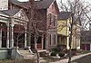 | September 29, 1988 (#88001712) | Roughly bounded by Main St., the Great Miami River, and Interstate 75 39°46′03″N 84°11′46″W / 39.7675°N 84.196111°W / 39.7675; -84.196111 (McPherson Town Historic District) | |
| 69 | Memorial Hall | 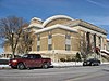 | July 14, 1988 (#88001062) | 125 E. 1st St. 39°45′51″N 84°11′23″W / 39.764167°N 84.189722°W / 39.764167; -84.189722 (Memorial Hall) | |
| 70 | Miami Valley Golf Course and Clubhouse |  | June 30, 2015 (#15000372) | 3311 Salem Ave. 39°47′30″N 84°14′15″W / 39.791667°N 84.237500°W / 39.791667; -84.237500 (Miami Valley Golf Course and Clubhouse) | Extends into Harrison Township, elsewhere in Montgomery County |
| 71 | Daniel Miller House |  | May 29, 1975 (#75001504) | 3525 Dandridge Ave. 39°45′59″N 84°14′49″W / 39.766389°N 84.246806°W / 39.766389; -84.246806 (Daniel Miller House) | |
| 72 | Montgomery County Courthouse | 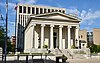 | January 26, 1970 (#70000510) | Northwestern corner of 3rd and Main Sts. 39°45′33″N 84°11′33″W / 39.759167°N 84.1925°W / 39.759167; -84.1925 (Montgomery County Courthouse) | |
| 73 | Jacob H.W. Mumma House |  | May 29, 1980 (#80003176) | 2239 Kipling Dr. 39°47′24″N 84°14′37″W / 39.790000°N 84.243611°W / 39.790000; -84.243611 (Jacob H.W. Mumma House) | |
| 74 | Mutual Home & Savings Association Building |  | December 16, 1982 (#82001480) | 120 W. 2nd St. 39°45′37″N 84°11′43″W / 39.760278°N 84.195278°W / 39.760278; -84.195278 (Mutual Home & Savings Association Building) | |
| 75 | Newcom House |  | July 21, 1980 (#80003177) | Carillon Historical Park 39°43′42″N 84°12′02″W / 39.728333°N 84.200556°W / 39.728333; -84.200556 (Newcom House) | Moved in 2009 from its previous location at 35 Moraine Circle in Kettering[5] |
| 76 | Nicholas Ohmer House |  | October 16, 1974 (#74001580) | 1350 Creighton St. 39°44′26″N 84°09′14″W / 39.740556°N 84.153889°W / 39.740556; -84.153889 (Nicholas Ohmer House) | |
| 77 | Old Post Office And Federal Building | 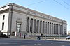 | March 10, 1975 (#75001505) | 120 W. 3rd St. 39°45′30″N 84°11′41″W / 39.758333°N 84.194722°W / 39.758333; -84.194722 (Old Post Office And Federal Building) | |
| 78 | Oregon Historic District |  | March 27, 1975 (#75001506) | Between Patterson Boulevard and Wayne Ave., north to Gates St. and south to U.S. Route 35 39°45′19″N 84°11′04″W / 39.755278°N 84.184444°W / 39.755278; -84.184444 (Oregon Historic District) | |
| 79 | Isaac Pollack House |  | December 16, 1974 (#74001581) | 208 W. Monument Ave.[10] 39°45′46″N 84°11′48″W / 39.762778°N 84.196667°W / 39.762778; -84.196667 (Isaac Pollack House) | |
| 80 | Rudolph Pretzinger House | 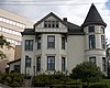 | August 24, 1979 (#79001901) | 908 S. Main St 39°44′45″N 84°11′16″W / 39.745833°N 84.187778°W / 39.745833; -84.187778 (Rudolph Pretzinger House) | |
| 81 | Red Oak-William C. Sherman House |  | September 8, 2000 (#00001064) | 1231 Hook Estates Dr. 39°47′43″N 84°14′00″W / 39.795278°N 84.233333°W / 39.795278; -84.233333 (Red Oak-William C. Sherman House) | |
| 82 | John R. Reynolds House |  | November 21, 1976 (#76001499) | 24 Klee St. 39°45′27″N 84°08′58″W / 39.7575°N 84.149444°W / 39.7575; -84.149444 (John R. Reynolds House) | |
| 83 | Rubicon Farm |  | September 29, 1976 (#76001500) | 1815 Brown St. 39°44′04″N 84°10′56″W / 39.734444°N 84.182222°W / 39.734444; -84.182222 (Rubicon Farm) | |
| 84 | Sachs and Pruden Ale Company Building | 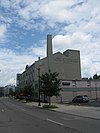 | August 12, 1991 (#91000973) | 127 Wyandot St. 39°45′30″N 84°11′15″W / 39.758333°N 84.1875°W / 39.758333; -84.1875 (Sachs and Pruden Ale Company Building) | Currently houses the Dayton Metro Library's Operations Center. From the 1980s through 2014 it was the long-time home of Hauer Music. |
| 85 | Sacred Heart Church | 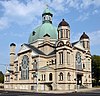 | October 22, 1987 (#87001885) | 217 W. 4th St. 39°45′28″N 84°11′43″W / 39.757778°N 84.195278°W / 39.757778; -84.195278 (Sacred Heart Church) | |
| 86 | St. Adalbert Polish Catholic Church |  | November 7, 1991 (#91001581) | 1511 Valley St. 39°47′01″N 84°09′22″W / 39.783611°N 84.156111°W / 39.783611; -84.156111 (St. Adalbert Polish Catholic Church) | |
| 87 | Saint Anne's Hill Historic District |  | June 5, 1986 (#86001214) | Roughly bounded by 4th, McClure, Josie, High, and Dutoit Sts. 39°45′24″N 84°10′23″W / 39.756667°N 84.173056°W / 39.756667; -84.173056 (Saint Anne's Hill Historic District) | |
| 88 | St. Mary Roman Catholic Church |  | April 21, 1983 (#83002012) | 543 Xenia Ave. 39°45′10″N 84°10′04″W / 39.752778°N 84.167778°W / 39.752778; -84.167778 (St. Mary Roman Catholic Church) | |
| 89 | St. Mary's Hall, University of Dayton |  | May 25, 1973 (#73001508) | 300 College Park 39°44′22″N 84°10′41″W / 39.739444°N 84.178056°W / 39.739444; -84.178056 (St. Mary's Hall, University of Dayton) | |
| 90 | St. Paul Evangelical Lutheran Church and Parish Hall | Upload image | August 14, 2023 (#100009223) | 239 Wayne Ave. 39°45′28″N 84°10′59″W / 39.7578°N 84.1830°W / 39.7578; -84.1830 (St. Paul Evangelical Lutheran Church and Parish Hall) | |
| 91 | Hyman Schriber Building | 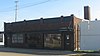 | May 26, 1988 (#88000667) | 306-308 Washington St. 39°45′06″N 84°11′41″W / 39.751667°N 84.194722°W / 39.751667; -84.194722 (Hyman Schriber Building) | |
| 92 | Shawen Acres |  | October 9, 1991 (#91001487) | 3304 N. Main St. 39°47′47″N 84°12′53″W / 39.796389°N 84.214722°W / 39.796389; -84.214722 (Shawen Acres) | |
| 93 | Sig's General Store |  | August 12, 1991 (#91000974) | 1400 Valley St. 39°46′54″N 84°09′30″W / 39.781667°N 84.158333°W / 39.781667; -84.158333 (Sig's General Store) | |
| 94 | Edwin Smith House | 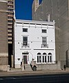 | August 13, 1974 (#74001582) | 131 W. 3rd St. 39°45′32″N 84°11′42″W / 39.758889°N 84.195°W / 39.758889; -84.195 (Edwin Smith House) | |
| 95 | South Park Historic District |  | August 23, 1984 (#84003794) | Roughly bounded by Park, Morton, Hickory, and Wayne Ave.; also roughly bounded by Wayne, Wyoming, Nathan, Oak, Alberta and Blaine 39°44′56″N 84°10′43″W / 39.748889°N 84.178611°W / 39.748889; -84.178611 (South Park Historic District) | Second set of boundaries represents a boundary increase of June 16, 1988 |
| 96 | Southern Ohio Lunatic Asylum |  | November 15, 1979 (#79001902) | 2335 Wayne Ave. 39°44′16″N 84°09′40″W / 39.737778°N 84.161111°W / 39.737778; -84.161111 (Southern Ohio Lunatic Asylum) | |
| 97 | Squirrel-Forest Historic District |  | October 14, 2010 (#10000827) | North of Homewood Ave. and along the west side of Forest Ave. 39°46′27″N 84°12′08″W / 39.774167°N 84.202222°W / 39.774167; -84.202222 (Squirrel-Forest Historic District) | |
| 98 | Steele's Hill-Grafton Hill Historic District |  | June 5, 1986 (#86001237) | Roughly bounded by Grand, Plymouth, Forest, and Salem 39°45′59″N 84°12′15″W / 39.766389°N 84.204167°W / 39.766389; -84.204167 (Steele's Hill-Grafton Hill Historic District) | A boundary increase was approved December 18, 2023. |
| 99 | John S. Stengel House |  | April 21, 1983 (#83002013) | 325 W. 2nd St. 39°45′37″N 84°11′52″W / 39.760278°N 84.197778°W / 39.760278; -84.197778 (John S. Stengel House) | Demolished |
| 100 | Stivers High School |  | August 17, 2001 (#01000896) | 1313 E. 5th St. 39°45′31″N 84°10′32″W / 39.758667°N 84.175556°W / 39.758667; -84.175556 (Stivers High School) | |
| 101 | Summit Street Young Women's Christian Association (YWCA) | Upload image | January 16, 2020 (#100004870) | 236 South Paul Laurence Dunbar St. 39°45′08″N 84°13′05″W / 39.7522°N 84.2180°W / 39.7522; -84.2180 (Summit Street Young Women's Christian Association (YWCA)) | |
| 102 | Traxler Mansion |  | April 24, 1979 (#79001903) | 42 Yale Ave. 39°46′14″N 84°12′54″W / 39.770556°N 84.215°W / 39.770556; -84.215 (Traxler Mansion) | |
| 103 | Unit III, Dayton Project |  | June 7, 2006 (#06000480) | 1601 W. 1st St. 39°45′25″N 84°13′19″W / 39.756944°N 84.221944°W / 39.756944; -84.221944 (Unit III, Dayton Project) | |
| 104 | United Brethren Publishing House | 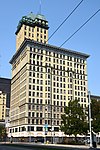 | December 10, 1993 (#93001391) | 40-46 S. Main St. (7-21 E. 4th St.) 39°45′30″N 84°11′29″W / 39.758333°N 84.191389°W / 39.758333; -84.191389 (United Brethren Publishing House) | |
| 105 | Victory Theater Building | 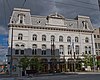 | June 22, 1972 (#72001037) | 138 N. Main St. 39°45′42″N 84°11′32″W / 39.761667°N 84.192222°W / 39.761667; -84.192222 (Victory Theater Building) | |
| 106 | Dr. Jefferson A. Walters House |  | November 20, 1974 (#74001583) | 35 E. 1st St. 39°45′46″N 84°11′29″W / 39.76275°N 84.191306°W / 39.76275; -84.191306 (Dr. Jefferson A. Walters House) | |
| 107 | West Third Street Historic District |  | January 25, 1989 (#88003194) | Roughly W. 3rd St. between Broadway and Shannon St. 39°45′21″N 84°12′43″W / 39.755833°N 84.211944°W / 39.755833; -84.211944 (West Third Street Historic District) | |
| 108 | Westbrock Funeral Home |  | March 10, 1988 (#88000205) | 1712 Wayne Ave. 39°44′41″N 84°10′06″W / 39.744722°N 84.168333°W / 39.744722; -84.168333 (Westbrock Funeral Home) | |
| 109 | Weustoff and Getz Company |  | September 3, 2014 (#14000547) | 210 Wayne Ave. 39°45′31″N 84°11′00″W / 39.758611°N 84.183333°W / 39.758611; -84.183333 (Weustoff and Getz Company) | |
| 110 | Women's Christian Association |  | May 13, 1976 (#76001501) | 800 W. 5th St. 39°45′11″N 84°12′28″W / 39.753056°N 84.207778°W / 39.753056; -84.207778 (Women's Christian Association) | Razed in November 2007 |
| 111 | Woodland Cemetery Association of Dayton Historic District |  | November 22, 2011 (#11000855) | 118 Woodland Ave. 39°44′38″N 84°10′30″W / 39.743888°N 84.175000°W / 39.743888; -84.175000 (Woodland Cemetery Association of Dayton Historic District) | |
| 112 | Woodland Cemetery Gateway, Chapel and Office |  | November 30, 1978 (#78002147) | 118 Woodland Ave. 39°44′34″N 84°10′45″W / 39.742778°N 84.179167°W / 39.742778; -84.179167 (Woodland Cemetery Gateway, Chapel and Office) | |
| 113 | Wright Company Factory |  | September 9, 2019 (#100004355) | 2701 Home Ave., Dayton Aviation Heritage National Historical Park 39°44′50″N 84°14′20″W / 39.7473°N 84.2390°W / 39.7473; -84.2390 (Wright Company Factory) | |
| 114 | Wright Cycle Company-Wright and Wright Printing Offices |  | February 13, 1986 (#86000236) | 22 S. Williams St. 39°45′13″N 84°12′43″W / 39.753611°N 84.211944°W / 39.753611; -84.211944 (Wright Cycle Company-Wright and Wright Printing Offices) | |
| 115 | Wright Flyer III |  | June 21, 1990 (#90001747) | Carillon Park, 2001 S. Patterson Boulevard 39°43′40″N 84°12′07″W / 39.727778°N 84.201944°W / 39.727778; -84.201944 (Wright Flyer III) |
Former listings
| [2] | Name on the Register | Image | Date listed | Date removed | Location | Description |
|---|---|---|---|---|---|---|
| 1 | Classic Theater |  | February 10, 1975 (#75001496) | January 31, 1995 | 815 W. 5th St. 39°45′12″N 84°12′30″W / 39.7533°N 84.2083°W / 39.7533; -84.2083 (Classic Theater) | Demolished in October 1991. [11] |
| 2 | Orville Wright Laboratory | Upload image | April 13, 1973 (#73001509) | February 20, 1980 | 15 N. Broadway |
See also
Wikimedia Commons has media related to National Register of Historic Places in Dayton, Ohio.
References
- ^ The latitude and longitude information provided in this table was derived originally from the National Register Information System, which has been found to be fairly accurate for about 99% of listings. Some locations in this table may have been corrected to current GPS standards.
- ^ a b Numbers represent an alphabetical ordering by significant words. Various colorings, defined here, differentiate National Historic Landmarks and historic districts from other NRHP buildings, structures, sites or objects.
- ^ "National Register Information System". National Register of Historic Places. National Park Service. April 24, 2008.
- ^ The eight-digit number below each date is the number assigned to each location in the National Register Information System database, which can be viewed by clicking the number.
- ^ a b Wynn, Kelli. Carillon Park Gets Historic Homes Sunday, Dayton Daily News, 2009-07-10. Accessed 2012-12-30.
- ^ Location derived from this SunWatch website; the NRIS lists it as "Address Restricted"
- ^ "St. Anne's Blog on the Hill: The End of the Hall". 4 August 2014.
- ^ McCarty, Mary. "Community makes final pilgrimage to historic Julienne High School". Dayton Daily News. Archived from the original on May 3, 2012. Retrieved November 15, 2016.
- ^ Location derived from Allman, John C. "A New Late Woodland Culture for Ohio: The Lichliter Village Site Near Dayton". Ohio Archaeologist 7.2 (1957): 59. The NRIS lists the site as "Address Restricted".
- ^ Location, Dayton International Peace Museum, 2010. Accessed 2012-11-27. The NRIS lists the house at its former location of 319 W. 3rd St.
- ^ "Tearing down a classic". Dayton Daily News. October 22, 1991. p. 4C. Retrieved August 15, 2022 – via Newspapers.com.
External links
- Historic districts in Dayton
- v
- t
- e
by county
- Adams
- Allen
- Ashland
- Ashtabula
- Athens
- Auglaize
- Belmont
- Brown
- Butler
- Carroll
- Champaign
- Clark
- Clermont
- Clinton
- Columbiana
- Coshocton
- Crawford
- Cuyahoga
- Darke
- Defiance
- Delaware
- Erie
- Fairfield
- Fayette
- Franklin
- Fulton
- Gallia
- Geauga
- Greene
- Guernsey
- Hamilton
- Hancock
- Hardin
- Harrison
- Henry
- Highland
- Hocking
- Holmes
- Huron
- Jackson
- Jefferson
- Knox
- Lake
- Lawrence
- Licking
- Logan
- Lorain
- Lucas
- Madison
- Mahoning
- Marion
- Medina
- Meigs
- Mercer
- Miami
- Monroe
- Montgomery
- Morgan
- Morrow
- Muskingum
- Noble
- Ottawa
- Paulding
- Perry
- Pickaway
- Pike
- Portage
- Preble
- Putnam
- Richland
- Ross
- Sandusky
- Scioto
- Seneca
- Shelby
- Stark
- Summit
- Trumbull
- Tuscarawas
- Union
- Van Wert
- Vinton
- Warren
- Washington
- Wayne
- Williams
- Wood
- Wyandot

- Akron
- Cincinnati
- Cleveland
- Columbus
- Dayton
- Sandusky


