National Register of Historic Places listings in Cooper County, Missouri
This is a list of the National Register of Historic Places listings in Cooper County, Missouri.
This is intended to be a complete list of the properties and districts on the National Register of Historic Places in Cooper County, Missouri, United States. Latitude and longitude coordinates are provided for many National Register properties and districts; these locations may be seen together in a map.[1]
There are 44 properties and districts listed on the National Register in the county, including one National Historic Landmark.
This National Park Service list is complete through NPS recent listings posted June 7, 2024.[2]
Map all coordinates using OpenStreetMap
Download coordinates as:
- KML
- GPX (all coordinates)
- GPX (primary coordinates)
- GPX (secondary coordinates)
Current listings
| [3] | Name on the Register | Image | Date listed[4] | Location | City or town | Description |
|---|---|---|---|---|---|---|
| 1 | Andrews-Wing House |  | March 16, 1990 (#82005304) | 733 Main St. 38°58′17″N 92°44′33″W / 38.971389°N 92.7425°W / 38.971389; -92.7425 (Andrews-Wing House) | Boonville | |
| 2 | Arrow Rock | October 15, 1966 (#66000422) | Arrow Rock State Park 39°04′00″N 92°56′41″W / 39.066667°N 92.944722°W / 39.066667; -92.944722 (Arrow Rock) | Arrow Rock | ||
| 3 | William S. and Mary Beckett House |  | March 16, 1990 (#82005288) | 821 Third St. 38°58′08″N 92°44′43″W / 38.968889°N 92.745278°W / 38.968889; -92.745278 (William S. and Mary Beckett House) | Boonville | |
| 4 | Blackwater Commercial Historic District | 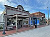 | January 20, 2005 (#04001520) | 100 Blk. of Main St., except for 118,120 and 122 Main St. 38°58′57″N 92°59′26″W / 38.9825°N 92.990556°W / 38.9825; -92.990556 (Blackwater Commercial Historic District) | Blackwater | |
| 5 | Blackwater Residential Historic District |  | September 5, 2009 (#09000597) | Parts of the 300-400 block of Trigg Ave., 300 block of Scott Ave. and the 300 block of Main St. 38°58′49″N 92°59′28″W / 38.980317°N 92.990983°W / 38.980317; -92.990983 (Blackwater Residential Historic District) | Blackwater | |
| 6 | Albert Gallatin Blakey House |  | March 16, 1990 (#82005289) | 226 W. Spring St. 38°58′24″N 92°45′10″W / 38.973333°N 92.752778°W / 38.973333; -92.752778 (Albert Gallatin Blakey House) | Boonville | |
| 7 | Boller House | Upload image | August 2, 1977 (#77000803) | 223 E. Spring St. 38°58′30″N 92°44′50″W / 38.975°N 92.747222°W / 38.975; -92.747222 (Boller House) | Boonville | Demolished.[5] |
| 8 | Cobblestone Street |  | March 16, 1990 (#82005293) | 100 Main St. 38°58′41″N 92°44′40″W / 38.978056°N 92.744444°W / 38.978056; -92.744444 (Cobblestone Street) | Boonville | |
| 9 | John S. Dauwalter House | 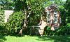 | March 16, 1990 (#82005296) | 817 Seventh St. 38°58′14″N 92°44′22″W / 38.970457°N 92.739582°W / 38.970457; -92.739582 (John S. Dauwalter House) | Boonville | |
| 10 | Dick-Kobel Homestead | Upload image | September 9, 1982 (#82003133) | W of Jamestown 38°44′48″N 92°35′33″W / 38.746667°N 92.5925°W / 38.746667; -92.5925 (Dick-Kobel Homestead) | Jamestown | |
| 11 | Duke and Mary Diggs House |  | March 16, 1990 (#82005297) | 1217 Rural St. 38°58′48″N 92°44′00″W / 38.980046°N 92.733335°W / 38.980046; -92.733335 (Duke and Mary Diggs House) | Boonville | |
| 12 | Fessler-Secongost House | Upload image | March 16, 1990 (#82005335) | 119 W. Morgan St. 38°58′32″N 92°45′02″W / 38.975556°N 92.750556°W / 38.975556; -92.750556 (Fessler-Secongost House) | Boonville | |
| 13 | Andrew Gantner House | 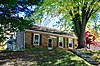 | March 16, 1990 (#82005303) | 1308 Sixth St. 38°57′52″N 92°44′18″W / 38.964444°N 92.738333°W / 38.964444; -92.738333 (Andrew Gantner House) | Boonville | |
| 14 | Hamilton-Brown Shoe Company Building | 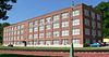 | March 16, 1990 (#82005305) | 301 1st Street[6] 38°58′29″N 92°45′01″W / 38.974780°N 92.750363°W / 38.974780; -92.750363 (Hamilton-Brown Shoe Company Building) | Boonville | |
| 15 | Harley Park Archeological Site | Upload image | October 15, 1970 (#70000329) | Address Restricted | Boonville | |
| 16 | Historic District A | 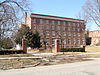 | January 24, 1983 (#83000979) | Vine and 2nd Sts. 38°58′15″N 92°44′48″W / 38.970833°N 92.746667°W / 38.970833; -92.746667 (Historic District A) | Boonville | |
| 17 | Historic District B |  | January 24, 1983 (#83000980) | 4th and E. Spring Sts. 38°58′26″N 92°44′40″W / 38.973889°N 92.744444°W / 38.973889; -92.744444 (Historic District B) | Boonville | |
| 18 | Historic District C |  | January 24, 1983 (#83000981) | E. High and 4th Sts 38°58′33″N 92°44′48″W / 38.975833°N 92.746667°W / 38.975833; -92.746667 (Historic District C) | Boonville | |
| 19 | Historic District D |  | January 24, 1983 (#83000982) | High and Main Sts. 38°58′32″N 92°44′37″W / 38.975556°N 92.743611°W / 38.975556; -92.743611 (Historic District D) | Boonville | |
| 20 | Historic District E |  | January 24, 1983 (#83000983) | High, Spring and Morgan Sts. 38°58′38″N 92°44′25″W / 38.977222°N 92.740278°W / 38.977222; -92.740278 (Historic District E) | Boonville | |
| 21 | Historic District F |  | January 24, 1983 (#83000984) | Extends North and South along 6th and 7th Sts. 38°58′20″N 92°44′24″W / 38.972222°N 92.74°W / 38.972222; -92.74 (Historic District F) | Boonville | |
| 22 | Historic District H | 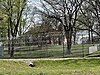 | January 24, 1983 (#83000985) | SE corner of E. Morgan St. and Reformatory Dr. 38°58′35″N 92°43′50″W / 38.976389°N 92.730556°W / 38.976389; -92.730556 (Historic District H) | Boonville | |
| 23 | Imhoff Archeological Site | Upload image | August 7, 1972 (#72000710) | Address Restricted | Blackwater | |
| 24 | Juliet Trigg Johnson House |  | March 16, 1990 (#82005327) | 1304 Main St. 38°57′50″N 92°44′24″W / 38.963889°N 92.74°W / 38.963889; -92.74 (Juliet Trigg Johnson House) | Boonville | |
| 25 | Wilbur T. and Rhoda Stephens Johnson House | 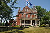 | March 16, 1990 (#82005322) | 821 Main 38°58′12″N 92°43′50″W / 38.97°N 92.730556°W / 38.97; -92.730556 (Wilbur T. and Rhoda Stephens Johnson House) | Boonville | |
| 26 | Lyric Theater |  | May 21, 1969 (#69000097) | NE corner of Main and Vine Sts. 38°58′26″N 92°44′33″W / 38.973889°N 92.7425°W / 38.973889; -92.7425 (Lyric Theater) | Boonville | |
| 27 | Meierhoffer House |  | March 16, 1990 (#82005317) | 120 E. High St. 38°58′34″N 92°45′01″W / 38.976111°N 92.750278°W / 38.976111; -92.750278 (Meierhoffer House) | Boonville | |
| 28 | Meierhoffer Sand Company Office Building |  | March 16, 1990 (#82005318) | 201 Second St. 38°58′33″N 92°45′01″W / 38.975833°N 92.750278°W / 38.975833; -92.750278 (Meierhoffer Sand Company Office Building) | Boonville | Apparently no longer extant[7] |
| 29 | Mellor Village and Mounds Archeological District | Upload image | May 21, 1969 (#69000098) | Address Restricted | Lamine | Boundaries increased on August 7, 1974 |
| 30 | Missouri, Kansas and Texas Railroad Depot |  | March 16, 1990 (#82005312) | 320 First St. 38°58′30″N 92°44′57″W / 38.975°N 92.749167°W / 38.975; -92.749167 (Missouri, Kansas and Texas Railroad Depot) | Boonville | |
| 31 | Morton-Myer House |  | March 16, 1990 (#82005316) | 1000 Eleventh St. 38°58′10″N 92°43′51″W / 38.969444°N 92.730833°W / 38.969444; -92.730833 (Morton-Myer House) | Boonville | |
| 32 | Mount Nebo Baptist Church | Upload image | May 23, 1986 (#86001111) | MO 135/E 38°48′12″N 92°53′22″W / 38.803333°N 92.889444°W / 38.803333; -92.889444 (Mount Nebo Baptist Church) | Pilot Grove | |
| 33 | Thomas Nelson House |  | March 16, 1990 (#82005302) | 700 Tenth St. 38°58′26″N 92°44′05″W / 38.973889°N 92.734722°W / 38.973889; -92.734722 (Thomas Nelson House) | Boonville | |
| 34 | New Lebanon Cumberland Presbyterian Church and School | Upload image | July 9, 1979 (#79001359) | MO A 38°45′53″N 92°56′20″W / 38.764722°N 92.938889°W / 38.764722; -92.938889 (New Lebanon Cumberland Presbyterian Church and School) | New Lebanon | |
| 35 | New Lebanon Historic District | Upload image | June 11, 1998 (#98000597) | Roughly, Area W and SE of jct of MO A and New Lebanon Loop 38°46′28″N 92°56′21″W / 38.774444°N 92.939167°W / 38.774444; -92.939167 (New Lebanon Historic District) | New Lebanon | |
| 36 | Phoenix American Cob Pipe Factory | 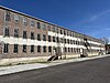 | November 14, 2019 (#100004604) | 2nd & Vine Sts. 38°58′22″N 92°44′52″W / 38.9728°N 92.7479°W / 38.9728; -92.7479 (Phoenix American Cob Pipe Factory) | Boonville | |
| 37 | Josephine Trigg Pigott House | 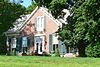 | March 16, 1990 (#82005328) | 1307 Sixth St. 38°57′52″N 92°44′21″W / 38.964463°N 92.739193°W / 38.964463; -92.739193 (Josephine Trigg Pigott House) | Boonville | |
| 38 | Pleasant Green | Upload image | July 29, 1977 (#77000804) | 8 miles SW of Pilot Grove on U.S. 135 38°48′11″N 92°59′15″W / 38.803056°N 92.9875°W / 38.803056; -92.9875 (Pleasant Green) | Pilot Grove | |
| 39 | Prairie View | 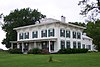 | September 20, 1982 (#82003134) | E of Pleasant Green off MO 135 38°47′36″N 92°55′51″W / 38.793333°N 92.930833°W / 38.793333; -92.930833 (Prairie View) | Pleasant Green | |
| 40 | Ravenswood |  | February 24, 1975 (#75001065) | NW of Bunceton on MO 5 38°49′19″N 92°50′17″W / 38.821944°N 92.838056°W / 38.821944; -92.838056 (Ravenswood) | Bunceton | |
| 41 | Roeschel-Toennes-Oswald Property |  | July 7, 1983 (#83000986) | Santa Fe Trail at West End Drive 38°58′22″N 92°45′22″W / 38.972698°N 92.756092°W / 38.972698; -92.756092 (Roeschel-Toennes-Oswald Property) | Boonville | |
| 42 | St. Matthew's Chapel A.M.E. Church |  | March 16, 1990 (#82005324) | 309 Spruce St. 38°58′14″N 92°44′41″W / 38.970437°N 92.744838°W / 38.970437; -92.744838 (St. Matthew's Chapel A.M.E. Church) | Boonville | |
| 43 | Sumner Public School |  | March 16, 1990 (#82005331) | 321 Spruce St. 38°58′14″N 92°44′39″W / 38.970521°N 92.744291°W / 38.970521; -92.744291 (Sumner Public School) | Boonville | |
| 44 | Wooldridge Archeological Site | Upload image | December 2, 1970 (#70000330) | Address Restricted | Wooldridge |
See also
- List of National Historic Landmarks in Missouri
- National Register of Historic Places listings in Missouri
References
Wikimedia Commons has media related to National Register of Historic Places in Cooper County, Missouri.
- ^ The latitude and longitude information provided in this table was derived originally from the National Register Information System, which has been found to be fairly accurate for about 99% of listings. Some locations in this table may have been corrected to current GPS standards.
- ^ National Park Service, United States Department of the Interior, "National Register of Historic Places: Weekly List Actions", retrieved June 7, 2024.
- ^ Numbers represent an alphabetical ordering by significant words. Various colorings, defined here, differentiate National Historic Landmarks and historic districts from other NRHP buildings, structures, sites or objects.
- ^ The eight-digit number below each date is the number assigned to each location in the National Register Information System database, which can be viewed by clicking the number.
- ^ "Cooper County National Register Listings." Missouri Department of Natural Resources. Retrieved 2015-06-20. Archived 2012-04-05 at Wayback Machine.
- ^ See address on awning in 2015 photo
- ^ The NRHP nominating form for the Meierhoffer Sand Company building gives an address of 201 2nd Street; a map included with the form shows it at the WSW corner of 2nd and High Streets. A 2015 photo shows High dead-ending just ENE of 2nd, and the entire WSW side of 2nd occupied by a parking lot.
- v
- t
- e
- List of U.S. National Historic Landmarks by state:
- Alabama
- Alaska
- Arizona
- Arkansas
- California
- Colorado
- Connecticut
- Delaware
- Florida
- Georgia
- Hawaii
- Idaho
- Illinois
- Indiana
- Iowa
- Kansas
- Kentucky
- Louisiana
- Maine
- Maryland
- Massachusetts
- Michigan
- Minnesota
- Mississippi
- Missouri
- Montana
- Nebraska
- Nevada
- New Hampshire
- New Jersey
- New Mexico
- New York
- North Carolina
- North Dakota
- Ohio
- Oklahoma
- Oregon
- Pennsylvania
- Rhode Island
- South Carolina
- South Dakota
- Tennessee
- Texas
- Utah
- Vermont
- Virginia
- Washington
- West Virginia
- Wisconsin
- Wyoming
 National Register of Historic Places portal
 Category


