Mrgashen
40°17′06″N 44°32′32″E / 40.28500°N 44.54222°E / 40.28500; 44.54222
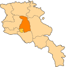
Place in Kotayk, Armenia


Mrgashen
Մրգաշեն
Մրգաշեն
(2008)
Mrgashen (Armenian: Մրգաշեն; until 1964, "the village attached to Sovkhoz No. 36") is a village in the Kotayk Province of Armenia. It is located along the left bank of the Arzni-Shamiram aqueduct. Mrgashen was officially founded in March 1960 around the state-owned collective farm or sovkhoz No. 6. The local economy is highly dependent on agriculture, based primarily on orchard cultivation and pig or cattle-breeding. The community currently has a school, kindergarten, house of culture (seating for 300), medical station (with 6 employees), and a library. 60% of households receive natural gas and drinking water for the village comes from the Arzakan-Yerevan network, while water for irrigation comes from the Arzni-Shamiram aqueduct.[1][2]
See also
- Kotayk Province
References
- ^ a b Kiesling, Brady; Kojian, Raffi (2005). Rediscovering Armenia: Guide (2nd ed.). Yerevan: Matit Graphic Design Studio. p. 100. ISBN 99941-0-121-8.
- ^ "Mrgashen(Kotayk)". CAA: Union of Communities of Armenia. Retrieved June 2, 2015.
- Mrgashen at GEOnet Names Server
- World Gazeteer: Armenia[dead link] – World-Gazetteer.com
- Report of the results of the 2001 Armenian Census, Statistical Committee of Armenia
- v
- t
- e
 Kotayk Province
Capital: Hrazdan
- Argel
- Getamej
- Kanakeravan
- Karashamb
- Mrgashen
- Nor Artamet
- Nor Geghi
- Teghenik


