List of listed buildings in Eccles, Scottish Borders
This is a list of listed buildings in the parish of Eccles in the Scottish Borders, Scotland.
Map all coordinates using OpenStreetMap
Download coordinates as:
- KML
- GPX (all coordinates)
- GPX (primary coordinates)
- GPX (secondary coordinates)
List
| Name | Location | Date Listed | Grid Ref. [note 1] | Geo-coordinates | Notes | LB Number [note 2] | Image |
|---|---|---|---|---|---|---|---|
| Belchester, Walled Garden Including Greenhouse, Garden Seat, Sundial And Potting Shed | 55°41′01″N 2°19′46″W / 55.683675°N 2.329342°W / 55.683675; -2.329342 (Belchester, Walled Garden Including Greenhouse, Garden Seat, Sundial And Potting Shed) | Category C(S) | 45863 |  Upload Photo | |||
| Birgham, Springhill Gardener's Cottage And Former Stable Range Including Cobbled Courtyard | 55°38′33″N 2°20′34″W / 55.642459°N 2.34277°W / 55.642459; -2.34277 (Birgham, Springhill Gardener's Cottage And Former Stable Range Including Cobbled Courtyard) | Category C(S) | 45866 | Upload Photo | |||
| The Braw Bothy, Stablegate Cottage And Stables, (Formerly To Eccles House), Including Cobbled Path, Ancillary Structures, Boundary Wall, Quadrant Walls And Gatepiers | 55°39′51″N 2°22′33″W / 55.664259°N 2.375817°W / 55.664259; -2.375817 (The Braw Bothy, Stablegate Cottage And Stables, (Formerly To Eccles House), Including Cobbled Path, Ancillary Structures, Boundary Wall, Quadrant Walls And Gatepiers) | Category B | 45867 | Upload Photo | |||
| Eccles House Including Service Wing, Ancillary Structures, Summer House, Boundary Walls, Quadrant Walls, Piers, Gatepiers And Gates | 55°39′48″N 2°22′37″W / 55.663213°N 2.377047°W / 55.663213; -2.377047 (Eccles House Including Service Wing, Ancillary Structures, Summer House, Boundary Walls, Quadrant Walls, Piers, Gatepiers And Gates) | Category B | 45872 | Upload Photo | |||
| Eccles Tofts Farmhouse Including Garden Walls, Quadrant Walls, Piers And Gatepiers | 55°41′56″N 2°23′23″W / 55.698808°N 2.389832°W / 55.698808; -2.389832 (Eccles Tofts Farmhouse Including Garden Walls, Quadrant Walls, Piers And Gatepiers) | Category B | 45879 | Upload Photo | |||
| Harlaw Farmhouse | 55°39′26″N 2°24′25″W / 55.657115°N 2.407043°W / 55.657115; -2.407043 (Harlaw Farmhouse) | Category B | 45880 | Upload Photo | |||
| Springwells Old Farmhouse Including Garden Wall | 55°41′07″N 2°22′22″W / 55.685347°N 2.372839°W / 55.685347; -2.372839 (Springwells Old Farmhouse Including Garden Wall) | Category C(S) | 45903 | Upload Photo | |||
| Stainrigg House Including Stables, Little Stainrigg (Former Groom's Cottage), Kennels, Cobbled Courtyard, Courtyard Walls And Gatepiers | 55°41′11″N 2°20′59″W / 55.686323°N 2.34985°W / 55.686323; -2.34985 (Stainrigg House Including Stables, Little Stainrigg (Former Groom's Cottage), Kennels, Cobbled Courtyard, Courtyard Walls And Gatepiers) | Category B | 45905 | Upload Photo | |||
| Eccles House, St Mary's Convent (Remains Of) | 55°39′52″N 2°22′39″W / 55.66455°N 2.377473°W / 55.66455; -2.377473 (Eccles House, St Mary's Convent (Remains Of)) | Category C(S) | 4077 | Upload Photo | |||
| Kames Stables Including Cobbled Courtyard To Front And Ancillary Structures (Further Stable Range And Barn With Hayloft) To Rear | 55°42′06″N 2°20′59″W / 55.701715°N 2.349605°W / 55.701715; -2.349605 (Kames Stables Including Cobbled Courtyard To Front And Ancillary Structures (Further Stable Range And Barn With Hayloft) To Rear) | Category B | 4116 | Upload Photo | |||
| Belchester, Stable Block Including Groom's Cottage, Ancillary Structures, Courtyard Walls And Gatepiers | 55°41′08″N 2°19′41″W / 55.685682°N 2.328134°W / 55.685682; -2.328134 (Belchester, Stable Block Including Groom's Cottage, Ancillary Structures, Courtyard Walls And Gatepiers) | Category B | 45862 | Upload Photo | |||
| Bughtrig, West Lodge Including Entrance Walls, Piers And Gatepiers | 55°41′40″N 2°19′38″W / 55.694516°N 2.327269°W / 55.694516; -2.327269 (Bughtrig, West Lodge Including Entrance Walls, Piers And Gatepiers) | Category C(S) | 45869 | Upload Photo | |||
| Eccles, Glebe House (Former Manse) Including Stables, Boundary Walls, Quadrant Walls And Gatepiers | 55°40′04″N 2°22′23″W / 55.667682°N 2.373116°W / 55.667682; -2.373116 (Eccles, Glebe House (Former Manse) Including Stables, Boundary Walls, Quadrant Walls And Gatepiers) | Category B | 45871 | Upload Photo | |||
| Eccles House, Walled Garden Including Greenhouses | 55°39′53″N 2°22′44″W / 55.664807°N 2.378811°W / 55.664807; -2.378811 (Eccles House, Walled Garden Including Greenhouses) | Category C(S) | 45874 | Upload Photo | |||
| Langrig Farmhouse | 55°42′00″N 2°18′49″W / 55.699979°N 2.313505°W / 55.699979; -2.313505 (Langrig Farmhouse) | Category C(S) | 45887 | Upload Photo | |||
| Loanknowe Farmhouse Including Boundary Walls, Mounting Stone, Gatepiers And Gate | 55°39′59″N 2°24′15″W / 55.666478°N 2.404135°W / 55.666478; -2.404135 (Loanknowe Farmhouse Including Boundary Walls, Mounting Stone, Gatepiers And Gate) | Category B | 45895 | Upload Photo | |||
| Mersington House Including Stable Block, Garden Walls, Boundary Walls, Quadrant Walls And Gatepiers | 55°41′29″N 2°21′31″W / 55.691338°N 2.358532°W / 55.691338; -2.358532 (Mersington House Including Stable Block, Garden Walls, Boundary Walls, Quadrant Walls And Gatepiers) | Category B | 45897 | Upload Photo | |||
| Ploughlands | 55°41′19″N 2°23′20″W / 55.688586°N 2.388935°W / 55.688586; -2.388935 (Ploughlands) | Category C(S) | 45900 | Upload Photo | |||
| Stainrigg, April Cottage | 55°41′15″N 2°20′52″W / 55.687479°N 2.347665°W / 55.687479; -2.347665 (Stainrigg, April Cottage) | Category C(S) | 45904 | Upload Photo | |||
| West Printonan, Threshing Barn And Cartshed And Granary | 55°42′33″N 2°20′58″W / 55.70929°N 2.34953°W / 55.70929; -2.34953 (West Printonan, Threshing Barn And Cartshed And Granary) | Category B | 45910 | Upload Photo | |||
| Anton's Hill House | 55°41′02″N 2°20′34″W / 55.683989°N 2.34272°W / 55.683989; -2.34272 (Anton's Hill House) | Category B | 6639 | Upload Photo | |||
| Eccles Church (Church Of Scotland) Including Graveyard, Mounting Stone, Boundary Walls And Gatepiers | 55°39′53″N 2°22′37″W / 55.664623°N 2.377061°W / 55.664623; -2.377061 (Eccles Church (Church Of Scotland) Including Graveyard, Mounting Stone, Boundary Walls And Gatepiers) | Category B | 4076 | 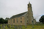 Upload another image | |||
| Anton's Hill, Quadrant Walls, Outer Walls And Piers Adjacent To North Lodge | 55°41′10″N 2°20′43″W / 55.686012°N 2.345314°W / 55.686012; -2.345314 (Anton's Hill, Quadrant Walls, Outer Walls And Piers Adjacent To North Lodge) | Category C(S) | 45859 | Upload Photo | |||
| Birgham, Hollybrae, Including Boundary Walls, Gatepiers And Gates | 55°38′38″N 2°20′14″W / 55.643912°N 2.337222°W / 55.643912; -2.337222 (Birgham, Hollybrae, Including Boundary Walls, Gatepiers And Gates) | Category C(S) | 45865 | Upload Photo | |||
| Bughtrig, Wood Cottage Including Ancillary Structure | 55°41′50″N 2°19′32″W / 55.697163°N 2.325526°W / 55.697163; -2.325526 (Bughtrig, Wood Cottage Including Ancillary Structure) | Category C(S) | 45870 | Upload Photo | |||
| Eccles Main Street, Eccles Mains Farmhouse Including Boundary Wall | 55°39′59″N 2°22′38″W / 55.666357°N 2.377221°W / 55.666357; -2.377221 (Eccles Main Street, Eccles Mains Farmhouse Including Boundary Wall) | Category C(S) | 45877 | 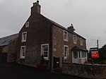 Upload another image | |||
| Eccles Newton Farmhouse Including Garden Railings, Walls And Gatepier | 55°39′29″N 2°21′25″W / 55.657981°N 2.35686°W / 55.657981; -2.35686 (Eccles Newton Farmhouse Including Garden Railings, Walls And Gatepier) | Category B | 45878 | Upload Photo | |||
| Kames Cottages | 55°42′04″N 2°21′02″W / 55.701236°N 2.350444°W / 55.701236; -2.350444 (Kames Cottages) | Category C(S) | 45882 | Upload Photo | |||
| Leitholm, Church Lane, Leitholm Church (Church Of Scotland) | 55°41′25″N 2°20′06″W / 55.690273°N 2.334901°W / 55.690273; -2.334901 (Leitholm, Church Lane, Leitholm Church (Church Of Scotland)) | Category C(S) | 45888 | Upload Photo | |||
| Leitholm, Main Street, Bughtrig Cottage | 55°41′31″N 2°19′55″W / 55.691881°N 2.331813°W / 55.691881; -2.331813 (Leitholm, Main Street, Bughtrig Cottage) | Category C(S) | 45892 | Upload Photo | |||
| Stainrigg, Well | 55°41′12″N 2°20′48″W / 55.686745°N 2.346609°W / 55.686745; -2.346609 (Stainrigg, Well) | Category C(S) | 45907 | Upload Photo | |||
| Bughtrig House | 55°41′46″N 2°19′34″W / 55.6962°N 2.32617°W / 55.6962; -2.32617 (Bughtrig House) | Category A | 4114 |  Upload another image | |||
| West Leitholm Bridge, Crossing Lamden Burn | 55°41′20″N 2°20′25″W / 55.688838°N 2.340249°W / 55.688838; -2.340249 (West Leitholm Bridge, Crossing Lamden Burn) | Category B | 211 | Upload Photo | |||
| Eccles House, Lodge | 55°39′53″N 2°22′52″W / 55.664836°N 2.381069°W / 55.664836; -2.381069 (Eccles House, Lodge) | Category C(S) | 45873 | Upload Photo | |||
| Homebank House | 55°38′59″N 2°18′59″W / 55.649664°N 2.316455°W / 55.649664; -2.316455 (Homebank House) | Category B | 45881 | Upload Photo | |||
| Kames Walled Garden | 55°42′02″N 2°20′58″W / 55.700682°N 2.349469°W / 55.700682; -2.349469 (Kames Walled Garden) | Category B | 45884 | Upload Photo | |||
| Leitholm, Main Street, Well Cottage | 55°41′26″N 2°20′06″W / 55.690506°N 2.335078°W / 55.690506; -2.335078 (Leitholm, Main Street, Well Cottage) | Category C(S) | 45894 | Upload Photo | |||
| Stonefold Farmhouse Including Garden Walls, Gatepiers And Gates | 55°40′31″N 2°24′40″W / 55.675305°N 2.411207°W / 55.675305; -2.411207 (Stonefold Farmhouse Including Garden Walls, Gatepiers And Gates) | Category C(S) | 45908 | Upload Photo | |||
| Eccles Main Street, Village Hall (Former Free Church) Including Boundary Walls | 55°39′57″N 2°22′38″W / 55.665926°N 2.377296°W / 55.665926; -2.377296 (Eccles Main Street, Village Hall (Former Free Church) Including Boundary Walls) | Category C(S) | 45876 | 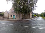 Upload another image | |||
| 1 And 2 Kames West Mains Farm Cottages | 55°41′42″N 2°20′52″W / 55.695089°N 2.347844°W / 55.695089; -2.347844 (1 And 2 Kames West Mains Farm Cottages) | Category C(S) | 45886 | Upload Photo | |||
| Leitholm, Main Street, Mansfield House Including Garden Walls | 55°41′22″N 2°20′20″W / 55.68957°N 2.338999°W / 55.68957; -2.338999 (Leitholm, Main Street, Mansfield House Including Garden Walls) | Category C(S) | 45889 | Upload Photo | |||
| Leitholm, Main Street, Braehead Cottage Including Boundary Wall | 55°41′23″N 2°20′19″W / 55.689625°N 2.338665°W / 55.689625; -2.338665 (Leitholm, Main Street, Braehead Cottage Including Boundary Wall) | Category C(S) | 45890 | Upload Photo | |||
| Leitholm, Main Street, Earnslaw House Including Boundary Wall, Railings And Gates | 55°41′27″N 2°20′07″W / 55.690739°N 2.335398°W / 55.690739; -2.335398 (Leitholm, Main Street, Earnslaw House Including Boundary Wall, Railings And Gates) | Category C(S) | 45891 | Upload Photo | |||
| Leitholm, Main Street, The Plough Hotel Including Cobbled Forecourt | 55°41′25″N 2°20′10″W / 55.690189°N 2.336061°W / 55.690189; -2.336061 (Leitholm, Main Street, The Plough Hotel Including Cobbled Forecourt) | Category C(S) | 45893 | Upload Photo | |||
| Pittlesheugh Farmhouse Including Garden Walls | 55°40′56″N 2°23′32″W / 55.682115°N 2.39221°W / 55.682115; -2.39221 (Pittlesheugh Farmhouse Including Garden Walls) | Category C(S) | 45899 | Upload Photo | |||
| Kames House Including Cobbled Courtyard | 55°42′08″N 2°20′51″W / 55.702134°N 2.347461°W / 55.702134; -2.347461 (Kames House Including Cobbled Courtyard) | Category A | 4115 | Upload Photo | |||
| Bartlehill Farmhouse | 55°39′25″N 2°21′51″W / 55.657061°N 2.364274°W / 55.657061; -2.364274 (Bartlehill Farmhouse) | Category C(S) | 45860 | Upload Photo | |||
| Lochrig Farmhouse | 55°42′20″N 2°19′43″W / 55.705439°N 2.328586°W / 55.705439; -2.328586 (Lochrig Farmhouse) | Category C(S) | 45896 | Upload Photo | |||
| Mersington Mill Including Garden Walls | 55°41′37″N 2°22′07″W / 55.693689°N 2.368703°W / 55.693689; -2.368703 (Mersington Mill Including Garden Walls) | Category C(S) | 45898 | Upload Photo | |||
| Purves Hall (House) Including Entrance Wall | 55°41′49″N 2°22′52″W / 55.696859°N 2.38103°W / 55.696859; -2.38103 (Purves Hall (House) Including Entrance Wall) | Category C(S) | 45901 | Upload Photo | |||
| Purves Hall, Walled Garden | 55°41′51″N 2°22′54″W / 55.697459°N 2.381657°W / 55.697459; -2.381657 (Purves Hall, Walled Garden) | Category C(S) | 45902 | Upload Photo | |||
| West Printonan Farmhouse Including Ancillary Structure And Garden Walls | 55°42′35″N 2°20′56″W / 55.709597°N 2.348864°W / 55.709597; -2.348864 (West Printonan Farmhouse Including Ancillary Structure And Garden Walls) | Category B | 45909 | Upload Photo | |||
| Belchester Including Terraced Garden, Sundial, Garden Railings, Gatepiers And Gate | 55°41′05″N 2°19′41″W / 55.684856°N 2.327968°W / 55.684856; -2.327968 (Belchester Including Terraced Garden, Sundial, Garden Railings, Gatepiers And Gate) | Category B | 4113 | Upload Photo | |||
| Birgham, Springhill House Including Dovecot, Well, Quadrant Walls, Gatepiers And Gates | 55°38′33″N 2°20′30″W / 55.642399°N 2.341768°W / 55.642399; -2.341768 (Birgham, Springhill House Including Dovecot, Well, Quadrant Walls, Gatepiers And Gates) | Category B | 4117 | Upload Photo | |||
| Bughtrig, East Lodge Including Entrance Walls And Gatepiers | 55°41′45″N 2°19′24″W / 55.695713°N 2.323366°W / 55.695713; -2.323366 (Bughtrig, East Lodge Including Entrance Walls And Gatepiers) | Category C(S) | 213 | Upload Photo | |||
| Belchester Lodge Including Quadrant Walls, Piers, Gatepiers And Gates | 55°40′51″N 2°20′04″W / 55.680803°N 2.334565°W / 55.680803; -2.334565 (Belchester Lodge Including Quadrant Walls, Piers, Gatepiers And Gates) | Category C(S) | 45861 | Upload Photo | |||
| Birgham, Dub Cottage | 55°38′27″N 2°20′47″W / 55.640777°N 2.346425°W / 55.640777; -2.346425 (Birgham, Dub Cottage) | Category C(S) | 45864 | Upload Photo | |||
| Bridge, Near Mersington House, Crossing Lambden Burn | 55°41′28″N 2°21′45″W / 55.69112°N 2.362443°W / 55.69112; -2.362443 (Bridge, Near Mersington House, Crossing Lambden Burn) | Category B | 45868 | Upload Photo | |||
| 23 Eccles Main Street, East Lodge (Formerly To Eccles House) Including Gatepiers | 55°39′55″N 2°22′43″W / 55.665275°N 2.378561°W / 55.665275; -2.378561 (23 Eccles Main Street, East Lodge (Formerly To Eccles House) Including Gatepiers) | Category C(S) | 45875 | Upload Photo | |||
| Kames North Entrance | 55°42′24″N 2°21′24″W / 55.706771°N 2.35678°W / 55.706771; -2.35678 (Kames North Entrance) | Category C(S) | 45883 | Upload Photo | |||
| Kames West Lodge Including Cobbled Forecourt, Quadrant Walls, Piers, Gatepiers And Gates | 55°42′05″N 2°21′23″W / 55.701345°N 2.356491°W / 55.701345; -2.356491 (Kames West Lodge Including Cobbled Forecourt, Quadrant Walls, Piers, Gatepiers And Gates) | Category C(S) | 45885 | Upload Photo | |||
| Stainrigg, Walled Garden Including Potting Shed, Outer Garden Walls And Railings | 55°41′12″N 2°20′56″W / 55.686793°N 2.348756°W / 55.686793; -2.348756 (Stainrigg, Walled Garden Including Potting Shed, Outer Garden Walls And Railings) | Category C(S) | 45906 | Upload Photo | |||
| Purves Hall (Tower) | 55°41′50″N 2°22′55″W / 55.697171°N 2.381924°W / 55.697171; -2.381924 (Purves Hall (Tower)) | Category B | 4144 | Upload Photo | |||
| Anton's Hill, East Lodge Including Gatepiers And Gate | 55°41′08″N 2°20′21″W / 55.685679°N 2.33906°W / 55.685679; -2.33906 (Anton's Hill, East Lodge Including Gatepiers And Gate) | Category C(S) | 45858 | Upload Photo |
Key
The scheme for classifying buildings in Scotland is:
- Category A: "buildings of national or international importance, either architectural or historic; or fine, little-altered examples of some particular period, style or building type."[1]
- Category B: "buildings of regional or more than local importance; or major examples of some particular period, style or building type, which may have been altered."[1]
- Category C: "buildings of local importance; lesser examples of any period, style, or building type, as originally constructed or moderately altered; and simple traditional buildings which group well with other listed buildings."[1]
In March 2016 there were 47,288 listed buildings in Scotland. Of these, 8% were Category A, and 50% were Category B, with the remaining 42% being Category C.[2]
Notes
- ^ Sometimes known as OSGB36, the grid reference (where provided) is based on the British national grid reference system used by the Ordnance Survey.
• "Guide to National Grid". Ordnance Survey. Retrieved 12 December 2007.
• "Get-a-map". Ordnance Survey. Retrieved 17 December 2007. - ^ Historic Environment Scotland assign a unique alphanumeric identifier to each designated site in Scotland, for listed buildings this always begins with "LB", for example "LB12345".
References
- All entries, addresses and coordinates are based on data from Historic Scotland. This data falls under the Open Government Licence
- ^ a b c "What is Listing?". Historic Environment Scotland. Retrieved 29 May 2018.
- ^ Scotland's Historic Environment Audit 2016 (PDF). Historic Environment Scotland and the Built Environment Forum Scotland. pp. 15–16. Retrieved 29 May 2018.
- v
- t
- e
- Abbey St Bathans
- Ancrum
- Ashkirk
- Ayton
- Bedrule
- Bowden
- Broughton, Glenholm and Kilbucho
- Bunkle and Preston
- Caddonfoot
- Castleton
- Cavers
- Channelkirk
- Chirnside
- Cockburnspath
- Coldingham
- Coldstream
- Crailing
- Cranshaws
- Drumelzier
- Duns
- Earlston
- Eccles
- Eckford
- Eddleston
- Ednam
- Edrom
- Ettrick
- Eyemouth
- Fala and Soutra
- Fogo
- Foulden
- Galashiels
- Gordon
- Greenlaw
- Hawick
- Heriot
- Hobkirk
- Hownam
- Hume
- Hutton
- Innerleithen
- Jedburgh
- Kelso
- Kirkhope
- Kirkurd
- Ladykirk
- Langton
- Lauder
- Legerwood
- Lilliesleaf
- Linton
- Longformacus
- Lyne
- Makerstoun
- Manor
- Maxton
- Melrose
- Mertoun
- Minto
- Mordington
- Morebattle
- Nenthorn
- Newlands
- Oxnam
- Peebles
- Penicuik
- Polwarth
- Roberton
- Roxburgh
- Selkirk
- Skirling
- Smailholm
- Southdean
- Sprouston
- St Boswells
- Stichill
- Stobo
- Stow
- Swinton
- Teviothead
- Traquair
- Tweedsmuir
- Westruther
- Whitsome
- Yarrow
- Yetholm


