Lauchert
River in Germany
| Lauchert | |
|---|---|
 | |
| Location | |
| Country | Germany |
| Physical characteristics | |
| Source | |
| • location | Swabian Alb |
| Mouth | |
• location | Danube |
• coordinates | 48°3′46″N 9°15′49″E / 48.06278°N 9.26361°E / 48.06278; 9.26361 |
| Length | 60.4 km (37.5 mi) [1] |
| Basin size | 456 km2 (176 sq mi) [1] |
| Basin features | |
| Progression | Danube→ Black Sea |
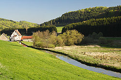
The Lauchert is a river in Baden-Württemberg, Germany, left tributary of the Danube. Its source is near Sonnenbühl, in the Swabian Alb. It is approx. 60 km long. It flows generally south through the small towns Gammertingen, Veringenstadt and Bingen. It flows into the Danube in Sigmaringendorf.
References
- ^ a b Map services of the Baden-Württemberg State Office for the Environment, Survey and Conservation (Landesanstalt für Umwelt, Messungen und Naturschutz Baden-Württemberg)
| Authority control databases |
|
|---|
- v
- t
- e


