Garyp
Village in Friesland, Netherlands
Garyp Garijp | |
|---|---|
Village | |
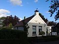
 St Peter's Church | |
 Coat of arms | |
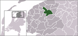
 Location of the village in Tytsjerksteradiel | |
53°9′59″N 5°58′12″E / 53.16639°N 5.97000°E / 53.16639; 5.97000 | |
| Country |  Netherlands Netherlands |
| Province |  Friesland Friesland |
| Municipality |  Tytsjerksteradiel Tytsjerksteradiel |
| Area | |
| • Total | 18.26 km2 (7.05 sq mi) |
| Elevation | −0.1 m (−0.3 ft) |
| Population (2021)[1] | |
| • Total | 1,895 |
| • Density | 100/km2 (270/sq mi) |
| Postal code | 9263[1] |
| Dialing code | 0511 |
Garyp (Dutch: Garijp[3]) is a village in the municipality of Tytsjerksteradiel within the province of Friesland, Netherlands. It had a population of around 1,894 in January 2017.[4]
History
The village was first mentioned between 1325 and 1336 as Garipe and means "village of the river bank".[5] Garyp developed into a stretched-out village on a sandy ridge. The current Dutch Reformed church dates from 1838; however, the first church was built around 1100.[6] Around 1930, the peat in the region was excavated.[7]
Garyp was home to 620 people in 1840.[7]
Gallery
-
 Village view
 -
 Farm Binnenrust
 - House in Garyp
-
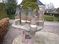 Village community statue


References
- ^ a b c "Kerncijfers wijken en buurten 2021". Central Bureau of Statistics. Retrieved 5 April 2022.
two entries
- ^ "Postcodetool for 9263AA". Actueel Hoogtebestand Nederland (in Dutch). Het Waterschapshuis. Retrieved 5 April 2022.
- ^ Taalunie (2019). "Friese namen" (in Dutch). Retrieved 18 November 2019.
- ^ Overzicht inwonersaantal Tytsjerksteradiel - Tytsjerksteradiel
- ^ "Garyp - (geografische naam)". Etymologiebank (in Dutch). Retrieved 5 April 2022.
- ^ Ronald Stenvert & Sabine Broekhoven (2000). "Garyp" (in Dutch). Zwolle: Waanders. ISBN 90 400 9476 4. Retrieved 5 April 2022.
- ^ a b "Garyp". Plaatsengids (in Dutch). Retrieved 5 April 2022.
Wikimedia Commons has media related to Garyp.
- v
- t
- e
 Tytsjerksteradiel
- Burgum
- Aldtsjerk
- Bartlehiem (partially)
- Earnewâld
- Eastermar
- Feanwâldsterwâl (partially)
- Garyp
- Gytsjerk
- Hurdegaryp
- Jistrum
- Mûnein
- Noardburgum
- Oentsjerk
- Ryptsjerk
- Sumar
- Suwâld
- Tytsjerk
- Wyns
- Altenburch
- De Joere
- Gytsjerksterhoeke
- Iniaheide
- It Heechsân
- It Wytfean
- Lytse Geast
- Kûkherne (partially)
- Noardermar
- Quatrebras
- Sânhuzen
- Sigerswâld
- Skûlenboarch
- Sumarreheide
- Swarteweisein
- Tergrêft (partially)
- Burgumer Lake
- De Leien
| Authority control databases: National |
|
|---|
| This Friesland location article is a stub. You can help Wikipedia by expanding it. |
- v
- t
- e


