Curitibanos
Municipality in South, Brazil
You can help expand this article with text translated from the corresponding article in Portuguese. (December 2011) Click [show] for important translation instructions.
- View a machine-translated version of the Portuguese article.
- Machine translation, like DeepL or Google Translate, is a useful starting point for translations, but translators must revise errors as necessary and confirm that the translation is accurate, rather than simply copy-pasting machine-translated text into the English Wikipedia.
- Do not translate text that appears unreliable or low-quality. If possible, verify the text with references provided in the foreign-language article.
- You must provide copyright attribution in the edit summary accompanying your translation by providing an interlanguage link to the source of your translation. A model attribution edit summary is
Content in this edit is translated from the existing Portuguese Wikipedia article at [[:pt:Curitibanos]]; see its history for attribution. - You may also add the template
{{Translated|pt|Curitibanos}}to the talk page. - For more guidance, see Wikipedia:Translation.
Place in South, Brazil

Flag

Seal
Ame Curitibanos (Love Curitibanos)
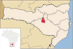
Location of Curitibanos
 Brazil
 Santa Catarina
 (2020 [2])
Curitibanos is a Brazilian municipality in the state of Santa Catarina. It is located at 27º16'58" south latitude and 50º35'04" west longitude, at an elevation of 987 metres. It has an area of 953.67 km² and its population, according to 2018 IBGE estimates, was 39,595 inhabitants.
Climate
Curitibanos has oceanic climate (Köppen climate classification: Cfb) on summer the temperature reaches 25 °C, on winter it reaches 7 °C, rarely falling below 0 °C or exceeding 13 °C. The highest temperature was 34 °C. The lowest temperature was -5 °C. Frost are common on winter.
| Climate data for Curitibanos, elevation 1,016 m (3,333 ft), (1976–2005) | |||||||||||||
|---|---|---|---|---|---|---|---|---|---|---|---|---|---|
| Month | Jan | Feb | Mar | Apr | May | Jun | Jul | Aug | Sep | Oct | Nov | Dec | Year |
| Record high °C (°F) | 33.2 (91.8) | 31.3 (88.3) | 31.5 (88.7) | 30.1 (86.2) | 27.6 (81.7) | 26.2 (79.2) | 28.6 (83.5) | 31.0 (87.8) | 32.0 (89.6) | 32.6 (90.7) | 33.5 (92.3) | 33.4 (92.1) | 33.5 (92.3) |
| Mean daily maximum °C (°F) | 26.3 (79.3) | 25.7 (78.3) | 24.9 (76.8) | 22.3 (72.1) | 18.9 (66.0) | 17.6 (63.7) | 17.5 (63.5) | 19.3 (66.7) | 19.5 (67.1) | 21.6 (70.9) | 24.1 (75.4) | 26.1 (79.0) | 22.0 (71.6) |
| Daily mean °C (°F) | 20.8 (69.4) | 20.5 (68.9) | 19.3 (66.7) | 16.9 (62.4) | 13.8 (56.8) | 12.2 (54.0) | 11.6 (52.9) | 13.3 (55.9) | 14.2 (57.6) | 16.7 (62.1) | 18.5 (65.3) | 20.3 (68.5) | 16.5 (61.7) |
| Mean daily minimum °C (°F) | 16.7 (62.1) | 16.5 (61.7) | 15.5 (59.9) | 13.2 (55.8) | 9.4 (48.9) | 8.1 (46.6) | 7.7 (45.9) | 8.8 (47.8) | 10.5 (50.9) | 12.8 (55.0) | 14.1 (57.4) | 16.0 (60.8) | 12.4 (54.4) |
| Record low °C (°F) | 6.8 (44.2) | 6.2 (43.2) | 3.1 (37.6) | 5.0 (41.0) | −5.0 (23.0) | −6.5 (20.3) | −6.0 (21.2) | −7.8 (18.0) | −2.3 (27.9) | 2.2 (36.0) | 2.6 (36.7) | 8.3 (46.9) | −7.8 (18.0) |
| Average precipitation mm (inches) | 168.5 (6.63) | 145.3 (5.72) | 133.6 (5.26) | 90.1 (3.55) | 103.8 (4.09) | 102.1 (4.02) | 122.6 (4.83) | 116.3 (4.58) | 139.6 (5.50) | 162.7 (6.41) | 83.4 (3.28) | 111.7 (4.40) | 1,479.7 (58.27) |
| Average relative humidity (%) | 79 | 79 | 80 | 79 | 79 | 80 | 78 | 74 | 77 | 79 | 74 | 74 | 78 |
| Mean monthly sunshine hours | 198 | 166 | 178 | 173 | 174 | 148 | 165 | 187 | 145 | 157 | 203 | 215 | 2,109 |
| Source: Empresa Brasileira de Pesquisa Agropecuária (EMBRAPA)[3] | |||||||||||||
See also
List of municipalities in Santa Catarina
References
External links
 Curitibanos travel guide from Wikivoyage
- v
- t
- e
- mesoregions of Santa Catarina
- Grande Florianópolis
- Norte Catarinense
- Oeste Catarinense
- Serrana
- Sul Catarinense
- Vale do Itajaí
Authority control databases | |
|---|---|
| International |
|
| National |
|
 | This Santa Catarina, Brazil location article is a stub. You can help Wikipedia by expanding it. |
- v
- t
- e


