Clachan Bridge
Hump-backed bridge in Argyll, Scotland
56°19′04″N 5°34′59″W / 56.31778°N 5.58306°W / 56.31778; -5.58306

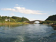
The Clachan Bridge (also known as the Bridge over the Atlantic) is a simple, single-arched, hump-backed, masonry bridge spanning the Clachan Sound, 13 kilometres (8 mi) southwest of Oban in Argyll and Bute, west of Scotland. It links the west coast of the Scottish mainland to the island of Seil.
The bridge was originally designed by John Stevenson of Oban (and not by Thomas Telford as sometimes quoted)[2] and was built between 1792 and 1793 by engineer Robert Mylne. The original design had two arches,[3] but it was finally built with a single high arch, of roughly 22 metres (72 ft) span and about 12 metres (39 ft) above the bed of the channel, to allow the passage of vessels of up to 40 tonnes (39 long tons) at high tide. The bridge is still in use today, forming part of the B844 road, and is in the care of Historic Scotland.
Because the Clachan Sound connects at both ends to the Atlantic Ocean, and might therefore be considered part of that ocean, the bridge came to be known as the Bridge over the Atlantic (Scottish Gaelic: a' Dhrochaid thar a' Chuain Siar).[3] Such an appellation has also been applied to certain other bridges having similar situations, such as the Brúgvin um Streymin in the Faroe Islands and between Lewis and Great Bernera in the Outer Hebrides.
Wildlife
The south wall of the bridge has been colonised by fairy foxglove (Erinus alpinus).
Occasionally whales have become trapped in the narrow Clachan Sound. In 1835 a whale measuring 24 metres (79 ft) with a lower jaw of 7 metres (23 ft) was stranded having become trapped in shallow water and unable to reverse out. In 1837, 192 pilot whales were caught in a similar fashion, the largest being 8 metres (26 ft) long.[4]
Gallery
-
 Clachan Bridge
 -
 View from the Clachan Bridge, looking north. Seil Island is on the left and the mainland on the right.
 -
 Clachan Bridge


References
- ^ "Seil, Clachan Bridge | Canmore". canmore.org.uk.
- ^ Paxton, R.; Shipway, J. (2007). Scotland - Highlands and Islands. Civil Engineering Heritage. London: Thomas Telford Publishing. ISBN 9780727734884.
- ^ a b "Bridge over the Atlantic". Am Baile.
- ^ Murray, W. H. (1977). The Companion Guide to the West Highlands of Scotland (7th ed.). London: Collins. p. 121. ISBN 0002168138.
External links
- Map sources for Clachan Bridge
Wikimedia Commons has media related to Clachan Bridge.
Portal:
 Scotland
| Authority control databases: Geographic |
|
|---|


