Bellerive-sur-Allier
You can help expand this article with text translated from the corresponding article in French. (December 2008) Click [show] for important translation instructions.
- View a machine-translated version of the French article.
- Machine translation, like DeepL or Google Translate, is a useful starting point for translations, but translators must revise errors as necessary and confirm that the translation is accurate, rather than simply copy-pasting machine-translated text into the English Wikipedia.
- Do not translate text that appears unreliable or low-quality. If possible, verify the text with references provided in the foreign-language article.
- You must provide copyright attribution in the edit summary accompanying your translation by providing an interlanguage link to the source of your translation. A model attribution edit summary is
Content in this edit is translated from the existing French Wikipedia article at [[:fr:Bellerive-sur-Allier]]; see its history for attribution. - You may also add the template
{{Translated|fr|Bellerive-sur-Allier}}to the talk page. - For more guidance, see Wikipedia:Translation.
Commune in Auvergne-Rhône-Alpes, France

Coat of arms
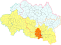
Location of Bellerive-sur-Allier

(2020–2026) François Sennepin[1]
1
(2021)[2]
03023 /03700
(avg. 280 m or 920 ft)
Bellerive-sur-Allier (French pronunciation: [bɛlʁiv syʁ alje]; Occitan: Vaissa) is a commune in the Allier department in central France.
Known as Vesse or Vaisse, it was renamed Bellerive-sur-Allier in 1903.[3]
Population
|
| ||||||||||||||||||||||||||||||||||||||||||||||||||||||||||||||||||||||||||||||||||||||||||||||||||||||||||||||||||
| Source: EHESS[3] and INSEE[4] | |||||||||||||||||||||||||||||||||||||||||||||||||||||||||||||||||||||||||||||||||||||||||||||||||||||||||||||||||||
Geography
Location
Bellerive-sur-Allier was member of Gannat district in 1793, which becomes an arrondissement in 1801; member of the arrondissement of Lapalisse from 1926 to 1942 and arrondissement of Vichy since 1942.[3] It was member of the canton of Escurolles from 1801[3] to 2015. The commune is the centralizer office of the canton of Bellerive-sur-Allier (11 communes) since March 2015.[5]
-
 Bellerive-sur-Allier in the former canton of Escurolles (before March 2015).
 -
 Bellerive-sur-Allier in the Vichy Val d'Allier conurbation.


Transportation
Road transportation
Bellerive-sur-Allier is at the junction of several main roads, including the main ones:
- the departemental road 2209 (D2209);
- the departmental road 1093 (D1093);
- the departemental road 984 (D984) passing by the town hall;
- the departemental road 6 (D6) coming from Saint-Pourçain-sur-Sioule.
These main roads are not enough to relieve congestion at peak hours (quasi-permanent stoppers on deck Bellerive) and the arrival of the A719 motorway in 2015, though it approaches the heart of the town, was not enough to improve the traffic conditions.
The main roads are closed to vehicles weighing more than 7.5 tonnes except for local traffic. Controls are organized regularly by municipal services to ensure that heavy vehicles comply with the regulations.[6]
Parking is free. It performs even side on even years and odd side on odd years.[7]
-
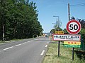 Entrance by D2209 from Gannat
 -
 Entrance by D2209 from Vichy
 -
 D1093
D1093


Cycling transportation
Bike lanes were built on part of the D2209, on the Avenue de Vichy (north-south between the Boussange roundabout and Georges-Beaugnies alley and in both directions beyond) and Avenue de la République in both directions and the roundabout of the Republic since 2010, as well as a portion of the Maurice-Chalus street, a portion of one-way between Jean-Ferlot street and the church (between two traffic calmings).
Bike paths also exist around the bridge of Europe.
In July 2010, a 2.7 km-cycle route was established between the Bellerive bridge and the swimming centre.[8] This service comes despite an impairment of this signaling equipment, better service. New roads have been built and existing roads were adapted.[9]
Round of the Lac d'Allier by bike is completed in July 2011.[10][11]
The Via Allier, a 27 km-route following the Allier River from Saint-Yorre to Billy, created in 2020, passes in Bellerive-sur-Allier.
-
 Berges de l'Allier renovated in 2019

Urban transportation
The city is served by five lines of the bus network MobiVie.
Politics and administration
The current mayor is François Sennepin, elected in 2020.[1]
Twin towns
 Hadamar, Germany
 Impruneta, Italy


See also
References
- ^ a b "Répertoire national des élus: les maires" (in French). data.gouv.fr, Plateforme ouverte des données publiques françaises. 13 September 2022.
- ^ "Populations légales 2021". The National Institute of Statistics and Economic Studies. 28 December 2023.
- ^ a b c d Des villages de Cassini aux communes d'aujourd'hui: Commune data sheet Bellerive-sur-Allier, EHESS (in French).
- ^ Population en historique depuis 1968, INSEE
- ^ "2014-265 decree". legifrance.gouv.fr (in French).
- ^ "Road safety" (in French).
- ^ "Parking" (in French). Archived from the original on 25 September 2014. Retrieved 25 September 2014.
- ^ Bourges, Anne (23 March 2010). "Nouvel itinéraire entre pont et piscine [New route between bridge and swimming centre]". La Montagne (in French).
- ^ Route from Vichy to Stade Aquatique on OpenStreetMap
- ^ Bourges, Anne (2 July 2011). "La circulation à vélo change de braquet". La Montagne (in French).
- ^ Round of the Lac d'Allier on OpenStreetMap
Wikimedia Commons has media related to Bellerive-sur-Allier.
- v
- t
- e

- Abrest
- Agonges
- Ainay-le-Château
- Andelaroche
- Archignat
- Arfeuilles
- Arpheuilles-Saint-Priest
- Arronnes
- Aubigny
- Audes
- Aurouër
- Autry-Issards
- Avermes
- Avrilly
- Bagneux
- Barberier
- Barrais-Bussolles
- Bayet
- Beaulon
- Beaune-d'Allier
- Bègues
- Bellenaves
- Bellerive-sur-Allier
- Bert
- Bessay-sur-Allier
- Besson
- Bézenet
- Billezois
- Billy
- Biozat
- Bizeneuille
- Blomard
- Bost
- Boucé
- Le Bouchaud
- Bourbon-l'Archambault
- Braize
- Bransat
- Bresnay
- Bressolles
- Le Brethon
- Le Breuil
- Broût-Vernet
- Brugheas
- Busset
- Buxières-les-Mines
- La Celle
- Cérilly
- Cesset
- La Chabanne
- Chambérat
- Chamblet
- Chantelle
- Chapeau
- La Chapelaude
- La Chapelle
- La Chapelle-aux-Chasses
- Chappes
- Chareil-Cintrat
- Charmeil
- Charmes
- Charroux
- Chassenard
- Château-sur-Allier
- Châtel-de-Neuvre
- Châtel-Montagne
- Châtelperron
- Châtelus
- Châtillon
- Chavenon
- Chavroches
- Chazemais
- Chemilly
- Chevagnes
- Chezelle
- Chézy
- Chirat-l'Église
- Chouvigny
- Cindré
- Cognat-Lyonne
- Colombier
- Commentry
- Contigny
- Cosne-d'Allier
- Coulandon
- Coulanges
- Couleuvre
- Courçais
- Coutansouze
- Couzon
- Créchy
- Cressanges
- Creuzier-le-Neuf
- Creuzier-le-Vieux
- Cusset
- Deneuille-lès-Chantelle
- Deneuille-les-Mines
- Désertines
- Deux-Chaises
- Diou
- Domérat
- Dompierre-sur-Besbre
- Le Donjon
- Doyet
- Droiturier
- Durdat-Larequille
- Ébreuil
- Échassières
- Escurolles
- Espinasse-Vozelle
- Estivareilles
- Étroussat
- Ferrières-sur-Sichon
- La Ferté-Hauterive
- Fleuriel
- Fourilles
- Franchesse
- Gannat
- Gannay-sur-Loire
- Garnat-sur-Engièvre
- Gennetines
- Gipcy
- Gouise
- La Guillermie
- Haut-Bocage
- Hauterive
- Hérisson
- Huriel
- Hyds
- Isle-et-Bardais
- Isserpent
- Jaligny-sur-Besbre
- Jenzat
- Laféline
- Lalizolle
- Lamaids
- Langy
- Lapalisse
- Laprugne
- Lavault-Sainte-Anne
- Lavoine
- Lenax
- Lételon
- Liernolles
- Lignerolles
- Limoise
- Loddes
- Loriges
- Louchy-Montfand
- Louroux-Bourbonnais
- Louroux-de-Beaune
- Louroux-de-Bouble
- Luneau
- Lurcy-Lévis
- Lusigny
- Magnet
- Malicorne
- Marcenat
- Marcillat-en-Combraille
- Marigny
- Mariol
- Le Mayet-d'École
- Le Mayet-de-Montagne
- Mazerier
- Mazirat
- Meaulne-Vitray
- Meillard
- Meillers
- Mercy
- Mesples
- Molinet
- Molles
- Monestier
- Monétay-sur-Allier
- Monétay-sur-Loire
- Montaiguët-en-Forez
- Montaigu-le-Blin
- Montbeugny
- Montcombroux-les-Mines
- Monteignet-sur-l'Andelot
- Le Montet
- Montilly
- Montluçonsubpr
- Montmarault
- Montoldre
- Montord
- Montvicq
- Moulinspref
- Murat
- Nades
- Nassigny
- Naves
- Néris-les-Bains
- Neuilly-en-Donjon
- Neuilly-le-Réal
- Neure
- Neuvy
- Nizerolles
- Noyant-d'Allier
- Paray-le-Frésil
- Paray-sous-Briailles
- Périgny
- La Petite-Marche
- Pierrefitte-sur-Loire
- Le Pin
- Poëzat
- Pouzy-Mésangy
- Prémilhat
- Quinssaines
- Reugny
- Rocles
- Rongères
- Ronnet
- Saint-Angel
- Saint-Aubin-le-Monial
- Saint-Bonnet-de-Four
- Saint-Bonnet-de-Rochefort
- Saint-Bonnet-Tronçais
- Saint-Caprais
- Saint-Christophe-en-Bourbonnais
- Saint-Clément
- Saint-Désiré
- Saint-Didier-en-Donjon
- Saint-Didier-la-Forêt
- Saint-Éloy-d'Allier
- Saint-Ennemond
- Sainte-Thérence
- Saint-Étienne-de-Vicq
- Saint-Fargeol
- Saint-Félix
- Saint-Genest
- Saint-Gérand-de-Vaux
- Saint-Gérand-le-Puy
- Saint-Germain-de-Salles
- Saint-Germain-des-Fossés
- Saint-Hilaire
- Saint-Léger-sur-Vouzance
- Saint-Léon
- Saint-Léopardin-d'Augy
- Saint-Loup
- Saint-Marcel-en-Marcillat
- Saint-Marcel-en-Murat
- Saint-Martin-des-Lais
- Saint-Martinien
- Saint-Menoux
- Saint-Nicolas-des-Biefs
- Saint-Palais
- Saint-Pierre-Laval
- Saint-Plaisir
- Saint-Pont
- Saint-Pourçain-sur-Besbre
- Saint-Pourçain-sur-Sioule
- Saint-Priest-d'Andelot
- Saint-Priest-en-Murat
- Saint-Prix
- Saint-Rémy-en-Rollat
- Saint-Sauvier
- Saint-Sornin
- Saint-Victor
- Saint-Voir
- Saint-Yorre
- Saligny-sur-Roudon
- Sanssat
- Saulcet
- Saulzet
- Sauvagny
- Sazeret
- Serbannes
- Servilly
- Seuillet
- Sorbier
- Souvigny
- Sussat
- Target
- Taxat-Senat
- Teillet-Argenty
- Terjat
- Le Theil
- Theneuille
- Thiel-sur-Acolin
- Thionne
- Tortezais
- Toulon-sur-Allier
- Treban
- Treignat
- Treteau
- Trévol
- Trézelles
- Tronget
- Urçay
- Ussel-d'Allier
- Valignat
- Valigny
- Vallon-en-Sully
- Varennes-sur-Allier
- Varennes-sur-Tèche
- Vaumas
- Vaux
- Veauce
- Venas
- Vendat
- Verneix
- Le Vernet
- Verneuil-en-Bourbonnais
- Vernusse
- Le Veurdre
- Vichysubpr
- Vicq
- Vieure
- Le Vilhain
- Villebret
- Villefranche-d'Allier
- Villeneuve-sur-Allier
- Viplaix
- Voussac
- Ygrande
- Yzeure
- pref: prefecture
- subpr: subprefecture
Authority control databases | |
|---|---|
| International |
|
| National |
|
| Other |
|


