Banda Deul
Deul temple at Banda, Purulia district
23°36′27″N 86°33′31″E / 23.6074°N 86.5587°E / 23.6074; 86.5587Banda Deul is an 11th-century temple in Banda village (also called Deulghera) in the Raghunathpur II CD block in the Raghunathpur subdivision of the Purulia district in the Indian state of West Bengal.
Geography


8km
5miles
5miles
J
H
A
R
K
H
A
N
D
Damodar River
Panchet Dam
Reservoir
Reservoir
Panchet
Hill
Hill
Joychandi Pahar
R

Bero
R
Santuri
R
Ramchandrapur
R
Muraddi
R
Madhukunda
R
Kashipur
H
Kalloli
R
Baranti
T
Raghunathpur
M
Lapara
CT
Adra
CT
Kantaranguri
CT
Arra
CT
Murulia
CT
Ramkanali
R
Telkupi
HV
Garh Panchkot
H
Banda Deul
H
Usir
R
Sarbari
R
Para
H
Nituria
R
Harmadih
R
Haraktor
H
Gobag
R
Cheliyama
R
Anara
R
Achkoda
H
Parbelia
CT
Hijuli
CT
Saltore
CT
Nabagram
CT
Shankara
CT
Chapari
CT
Dubra
CT
Kanki
CT
Santaldih
CT
Places in Raghunathpur subdivision in Purulia district
M: municipal town, CT: census town, R: rural/ urban centre, H: historical/ religious centre, T: tourist centre
Owing to space constraints in the small map, the actual locations in a larger map may vary slightly
M: municipal town, CT: census town, R: rural/ urban centre, H: historical/ religious centre, T: tourist centre
Owing to space constraints in the small map, the actual locations in a larger map may vary slightly
Location
Banda is located at 23°36′27″N 86°33′31″E / 23.6074°N 86.5587°E / 23.6074; 86.5587.
Banda is 1 km from Cheliyama, which contains the Radha Vinod temple with the most richly decorated terracotta carvings.[1]
There are three dilapidated deuls at Para, located nearby, belonging to the 10-11th century or earlier.[2]
Note: The map alongside presents some of the notable locations in the subdivision. All places marked in the map are linked in the larger full screen map.
Banda Deul
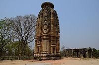
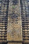
There is a temple at Banda, which is described by the Archaeological Survey of India as a rekha deul of triratha variety in sandstone.[3] The temple is richly decorated, the themes being creepers, scroll work and stylised chaitya window.[3]The temple is datable to c. 11th century AD.[3]
In 1872, the archaeologist J.D.Beglar came across this temple, then covered with deep vegetation in a forest. The area around the deul was cleared and it started attracting attention. It is not clear whether it was a Hindu or a Jain temple. The ground plan is star shpaed.[3] Internally the cella is square with a rectangular Mukhamandapa.[3] The temple consists of a single cell and it once had a mandapa.[4]
The temple had a mandapa which has largely collapsed, However, eight pillars are still there supporting the cross beams. The temple has a water outlet with a makara (crocodile) head.[1]
According to the List of Monuments of National Importance in West Bengal the old temple at Banda is an ASI listed monument.[5]
Banda picture gallery
-
 The deul at Banda with remains of the mandapa
 -
 The deul at Banda
 -
 Stone decoration
 -
 Crocodile head shaped water outlet
 -
 Sculpture on the wall of temple of Banda
 -
 Mandapa in front of the temple of Banda


References
- ^ a b "District Census Handbook, Puruliya, Series 20, Part XII A" (PDF). Banda - Page 101: Brief Description of Places of Religious, Historical or Archaeological Importance and Places of Tourist Importance of the District. Directorate of Census Operations, West Bengal. Retrieved 23 January 2020.
- ^ Dutta, Rangan. "Temples of Para, Purulia". Wordpress. Retrieved 10 January 2020.
- ^ a b c d e "Old temple at Banda (locally known as deul)". ASI, Kolkata Circle. Retrieved 23 January 2020.
- ^ "Report of a Tour through the Bengal Provinces".
- ^ "List of Ancient Monuments and Archaeological Sites and Remains of West Bengal - Archaeological Survey of India". Item no. 134. ASI. Retrieved 25 January 2020.
External links
Wikimedia Commons has media related to Banda deul temple.
- v
- t
- e
Purulia district topics
- Banda Deul
- Bargi
- Bengali Language Movement (Manbhum)
- Charra Airfield
- Chhau dance
- Chhau mask
- Chota Nagpur Plateau
- Deulghata
- Dharmathakur
- Garh Panchkot
- Jungle Mahals
- Manbhum
- Purulia arms drop case
- Sarak
- Telkupi
| Purulia Sadar subdivision |
|
|---|---|
| Manbazar subdivision |
|
| Jhalda subdivision | |
| Raghunathpur subdivision |
|
- Purulia
- Cities, towns and locations in Purulia district
- People from Purulia district
- Villages in Purulia district
- Damodar Valley
| ||
|---|---|---|
| Bankura |  | |
| Birbhum | ||
| Cooch Behar |
| |
| Darjeeling | ||
| Hooghly | ||
| Howrah | ||
| Jalpaiguri | ||
| Kolkata | ||
| Murshidabad | ||
| Nadia | ||
| North 24 Parganas | ||
| Paschim Bardhaman | ||
| Purba Bardhaman | ||
| Paschim Medinipur | ||
| Purba Medinipur | ||
| Purulia |
| |
| South 24 Parganas | ||
| Malda | ||
| See also | Temple towns in West Bengal | |
 | This article about an Indian religious building or structure is a stub. You can help Wikipedia by expanding it. |
- v
- t
- e


