Amini, India
- IST (UTC+5:30)
Amini is a census town in the Union Territory of Lakshadweep, India. It is also the name of the island where the town stands and of the atoll that contains that island. It lies 407 km (253 mi) west of the city of Kochi.
History
Amini Island was one of the first islands in the archipelago to be inhabited. The artisans on this island are known for making walking sticks out of coconut shells and tortoise shells as well as carved stone and coral motifs.
Geography
The channel between Amini Island and Cardamom Island is safe and deep, but depths of less than 10 meters project 0.5 mile south from the south tip of the reefs surrounding Cardamom Island. Amini Island Light is shown on the south point of the island. Amini Island, the most important of the Amindivi Islands, is oval, with the long axis oriented northeast–southwest. It is 2.8 km long and up to 1.3 km wide, yielding a land area of 2.71 km2 (1.05 sq mi). It is fringed by a reef 0.3 to 0.6 km wide.
Demographics
Amini village is in the middle of the west coast of the Island. A raised stone platform jetty, with steps leading to the beach, is in front of the village. There is a post office and a hospital at the village. The small village of Hujrapali is on the east coast. As of the 2011 India census,[3] the island of Amini had a population of 7,657. Males constitute 50% of the population and females 50%. Amini has an average literacy rate of 71%, higher than the national average of 59.5%, with 55% of the males and 45% of females literate. 15% of the population is under 6 years of age.
Pitti Bank
Amini Island lies at the northeastern extremity of Pitti Bank, 42 km from small, uninhabited Pitti Island (not to be confused with Pitti Islet of Kalpeni Atoll), which is located at the opposite southwestern extremity of the bank. Pitti Bank, also oriented along a northeast–southwest axis, is 49 km long, in the northern part from 2 to 7 km wide and in the southern part up to 18 km wide. Pitti Bank may be considered a largely submerged and sunken atoll, with an estimated lagoon area of 415 km2 (160 sq mi), with just the two islands Amini and Pitti remaining at its opposite ends. Kadmat island, although just 5 km northeast of Amini Island, is separated from it by a deep channel and thus forms a separate geographical unit.
Administration
The bank belongs to the township of Amini Island of Aminidivi Tehsil.[4]
Image gallery
-
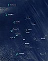 Satellite picture showing the atolls of the Lakshadweep except for Minicoy
 -
 Map
Map


References
- ^ "Islandwise Area and Population - 2011 Census" (PDF). Government of Lakshadweep. Archived from the original (PDF) on 22 July 2016.
- ^ Registration Plate Numbers added to ISO Code
- ^ "Census of India 2001: Data from the 2001 Census, including cities, villages and towns (Provisional)". Census Commission of India. Archived from the original on 16 June 2004. Retrieved 1 November 2008.
- ^ Tehsils info
 India portal
 Islands portal


 Lakshadweep travel guide from Wikivoyage
- Hydrographic Description (Indian Ocean Pilot)
- v
- t
- e
| Animal | |
|---|---|
| Bird | |
| Tree | |
| Flower |
| Administrator | |
|---|---|
| Lok Sabha constituency | Lakshadweep |
| District(s) |
| Islands |
| ||||||
|---|---|---|---|---|---|---|---|
| Protected areas | |||||||
| Official | |
|---|---|
| Spoken |
Authority control databases | |
|---|---|
| International |
|
| National |
|


