Aliso (river)
Stream in the department of Haute-Corse, Corsica
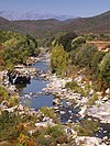
42°40′43″N 9°18′06″E / 42.6786°N 9.3017°E / 42.6786; 9.3017 The Aliso River (French: Rivière l'Aliso) is a small coastal river in the department of Haute-Corse, Corsica, France.
Course
The Aliso is 20.51 kilometres (12.74 mi) long.[1] Its source is at an elevation of 1,172 metres (3,845 ft). It rises to the south of the 1,509 metres (4,951 ft) Cima di Grimaseta and flows northeast and then north to the Mediterranean Sea at Saint-Florent.[2] The river crosses the communes of Oletta, Olmeta-di-Tuda, Piève, Rapale, Sorio, Saint-Florent, San-Gavino-di-Tenda and Santo-Pietro-di-Tenda.[1]
Hydrology
Measurements of the river flow were taken at the Oletta [Malpergo] station from 1972 to 1996. The watershed above this station covers 68.6 square kilometres (26.5 sq mi). Annual precipitation was calculated as 266 millimetres (10.5 in). The average flow of water throughout the year was 0.577 cubic metres per second (20.4 cu ft/s).[3]
| Month | Flow |
|---|---|
| Jan | 1.010 |
| Feb | 1.260 |
| Mar | 1.200 |
| Apr | 1.150 |
| May | 0.577 |
| Jun | 0.208 |
| Jul | 0.076 |
| Aug | 0.039 |
| Sep | 0.079 |
| Oct | 0.151 |
| Nov | 0.579 |
| Dec | 0.651 |
Tributaries

The following streams (ruisseaux) are tributaries of the Aliso, ordered by length, and sub-tributaries:[1]
- la Concia (9 km)
- Mercurio (2 km)
- Loto (2 km)
- Lenza Longa (2 km)
- Salinelle (8 km)
- Valdo (5 km)
- Campodata (4 km)
- Gué San Nicolao (4 km)
- Furmicaiola (4 km)
- Mondole Bianco (2 km)
- Vomera (2 km)
- Lenze (2 km)
- Cicendolle (3 km)
- Aghiola (1 km)
- Salti (8 km)
- Leccia Torta (1 km)
- Porraghia (8 km)
- Valdu a u Mulinu (4 km)
- Callane (3 km)
- Tettole (3 km)
- Corti Maio (2 km)
- Parata u a Carcu (2 km)
- Vaccaia (2 km)
- Perchia (3 km)
- Pedilama (1 km)
- Capina (2 km)
- Vaccario (1 km)
- Agnani (1 km)
- Valdu a u Mulinu (4 km)
- Fiumicellu (7 km)
- Lavandaio (2 km)
- Morello (5 km)
- Pilocaccio (2 km)
- Stollu (4 km)
- Campucassu (4 km)
- Piedi Gatta (2 km)
- di Pétricali (3 km)
- Ficapenta (3 km)
- Carpiniccia (3 km)
- Codiglione (1 km)
- Furnelli (2 km)
- Canne (2 km)
- Spelonca (2 km)
Notes
- ^ a b c L'Aliso Sandre.
- ^ Relation: L'Aliso (8472974).
- ^ a b L'Aliso à Oletta [Malpergo] eaufrance.
Sources
- "L'Aliso à Oletta [Malpergo]", eaufrance (in French), © Ministère de l'Ecologie, du Développement Durable et de l'Energie, 2015, retrieved 2021-11-24
- "L'Aliso", Sandre (in French), Service d'administration nationale des données et référentiels sur l'eau, retrieved 2021-11-24
- "Relation: L'Aliso (8472974)", OpenStreetMap, retrieved 2021-11-24
- v
- t
- e
Waterbodies of the Haute-Corse department 

| Lagoons |  | |
|---|---|---|
| Lakes | ||
| Reservoirs |
Clockwise; west to north to east to south | ||||||||
| Coastal |
|  | ||||||
|---|---|---|---|---|---|---|---|---|
| Tributaries |
| |||||||
- Communes
- Landforms
- Waterbodies
- Corse-du-Sud


