Ōnuma Quasi-National Park
Quasi-National park in Hokkaidō
42°00′44″N 140°40′16″E / 42.0121°N 140.671°E / 42.0121; 140.671[1] Ramsar Wetland
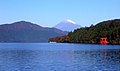
Ōnuma Quasi-National Park (大沼国定公園, Ōnuma Kokutei Kōen) is a 90.83 km2 (35.07 sq mi)[1] quasi-national park on the Oshima Peninsula in southwest Hokkaidō, Japan. The park encompasses the volcanic Hokkaidō Komagatake (北海道駒ケ岳, Hokkaidō Koma-ga-take) as well as the Ōnuma (大沼) and Konuma (小沼) ponds, which abut against the west slope of the mountain. The park, which was designated as quasi-national in 1958, is the smallest major park in Hokkaidō.
Ōnuma and Konuma were created when mudflows due to eruptions of Hokkaidō Koma-ga-take dammed up depressions at the base of the mountain. The ponds, which are dotted with watershields, are surrounded by birch and maple forests.
Related cities, towns and villages
See also
References
- ^ a b Onuma Quasi National Park protectedplanet.net
- ^ "Onuma". Ramsar Sites Information Service. Retrieved 25 April 2018.
External links
- J-IBIS (in Japanese)
- v
- t
- e
- Akan
- Amami Guntō
- Ashizuri-Uwakai
- Aso-Kujū
- Bandai-Asahi
- Chichibu-Tama-Kai
- Chūbu-Sangaku
- Daisen-Oki
- Daisetsuzan
- Fuji-Hakone-Izu
- Hakusan
- Iriomote-Ishigaki
- Ise-Shima
- Jōshinetsu Kōgen
- Kerama Shotō
- Kirishima-Kinkowan
- Kushiro Shitsugen
- Minami Alps
- Myōkō-Togakushi Renzan
- Nikkō
- Ogasawara
- Oze
- Rishiri-Rebun-Sarobetsu
- Saikai
- Sanin Kaigan
- Sanriku Fukkō
- Setonaikai
- Shikotsu-Tōya
- Shiretoko
- Towada-Hachimantai
- Unzen-Amakusa
- Yanbaru
- Yakushima
- Yoshino-Kumano
- Abashiri
- Aichi Kōgen
- Akiyoshidai
- Biwako
- Chōkai
- Echigo Sanzan-Tadami
- Echizen-Kaga Kaigan
- Genkai
- Hayachine
- Hiba-Dōgo-Taishaku
- Hida-Kisogawa
- Hidaka-sanmyaku Erimo
- Hyōnosen-Ushiroyama-Nagisan
- Ibi-Sekigahara-Yōrō
- Iki-Tsushima
- Ishizuchi
- Kita Nagato
- Kitakyūshū
- Kongō-Ikoma-Kisen
- Kōya-Ryūjin
- Kurikoma
- Kyoto Tamba Kōgen
- Kyūshū Chūō Sanchi
- Meiji no Mori Minō
- Meiji no Mori Takao
- Mikawa Wan
- Minami Bōsō
- Minami Sanriku Kinkasan
- Murō-Akame-Aoyama
- Muroto-Anan Kaigan
- Myōgi-Arafune-Saku Kōgen
- Nichinan Kaigan
- Nippō Kaigan
- Niseko-Shakotan-Otaru Kaigan
- Nishi-Chūgoku Sanchi
- Noto Hantō
- Oga
- Okinawa Kaigan
- Okinawa Senseki
- Ōnuma
- Sado-Yahiko-Yoneyama
- Shimokita Hantō
- Shokanbetsu-Teuri-Yagishiri
- Sobo Katamuki
- Suigō-Tsukuba
- Suzuka
- Tango-Amanohashidate-Ōeyama
- Tanzawa-Ōyama
- Tenryū-Okumikawa
- Tsugaru
- Tsurugisan
- Wakasa Wan
- Yaba-Hita-Hikosan
- Yamato-Aogaki
- Yatsugatake-Chūshin Kōgen
- Zaō
| Authority control databases |
|
|---|
 | This Hokkaidō location article is a stub. You can help Wikipedia by expanding it. |
- v
- t
- e
 | This article about a national/quasi-national park or protected area in Japan, or related topic is a stub. You can help Wikipedia by expanding it. |
- v
- t
- e


